Fire lookout · Swain County, North Carolina
Mount Noble Lookout
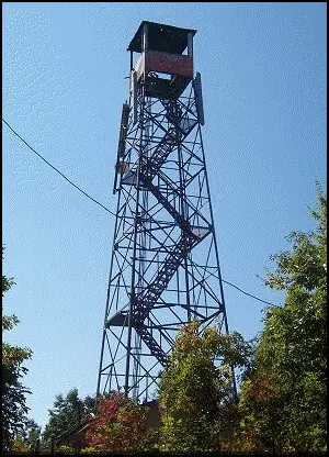
BIA 60-foot Aermotor tower on the Qualla Boundary, built 1957 to replace a 1930s wooden tower; unused since the 1960s; cab in poor shape; access reports conflict.
- Standing
- Restricted access
- Verified
Visit & stay
Not rentable. As far as we know, this lookout cannot be booked for overnight stays.
Access
Restricted access
Access is seasonal, gated or needs a permit. Check before you go. On the Qualla Boundary (Eastern Band of Cherokee Indians land). A 2018 blog (July 2018) found a chain-link fence barring entry. An undated trail guide says the tower remains open to the public, but the same guide carries a May 2018 update: BIA Forestry rebuilt the chain-link fence around the base of the tower and closed it until further notice. No later access record found; sources disagree.
- Can you climb it?
- Unknown
- Road to the top?
- No, you have to hike
- Trail
- Hike from the Fire Mountain Trail System, minutes from downtown Cherokee: 2.4 to 2.6 miles and about 1,600 feet of climb, depending on the source. Sources disagree on whether the tower is open (the trail guide's May 2018 update says it was closed until further notice), and the cab floor is missing boards. Do not climb past a fence.
- Staffing
- Not staffed (as of 1960s (approximate))
Facts
- Status
- Type
- Cab on a tower60-foot steel Aermotor tower with a 7-by-7-foot metal cabThe design: Aermotor
- Built of
- SteelGoing by its design; no source says so in words.
- Built
- 1957
- Height
- 60 ft (18.3 m)
- Elevation
- 3,840 ft (1,170 m)
- Agency
- Bureau of Indian Affairs (Eastern Cherokee Agency cooperator, per Register)
- Land
- Unknown
- Location
- Swain County, North Carolina
- Coordinates
- 35.49615, −83.33425
- Registers
- NHLR US 725 · NC 19
- NGS FB 2563
- This entry
- VerifiedResearched, then checked independently. Updated 9 Oct 2026.
- Firefinder id
us-nc-mount-noble
View from the cab
What you see from the cab: every ridge out to about 93 miles, the named peaks in sight, and other fire lookouts within view, worked out from terrain data in your browser.
Downloads about 3.2 MB of terrain data the first time.
Or see what it could see on the map: the ground in its line of sight.
History
Then and now
- 1957 BuiltBuilt by the Bureau of Indian Affairs (Register; 2018 blog; trail guide)Sources: nhlr.org, sweetwilder.com, docslib.org
- 1957 Replaced by a new structureReplaced a wooden tower dating from the 1930s (Register; 2018 blog)Sources: nhlr.org, sweetwilder.com
- 1960 Last staffedUsed for fire detection 'until the 1960s' per the 2018 blog, which cites Peter Barr's book. Approximate.Source: sweetwilder.com
- No record between 1960 and 2008
- 2008 Added to the National Historic Lookout RegisterRegistered April 2, 2008; nominated by Peter J. BarrSource: nhlr.org
- 2008 EventRegister: unused for many years; the BIA and a North Carolina division of the Forest Fire Lookout Association were working on a restoration plan. No restoration found in later sources.Source: nhlr.org
- TodayStandingIt still stands, as far as our sources know.
Old maps of this spot
USGS topographic maps from the years a lookout stood may show it, often as a small symbol labelled “Lookout”. See the old topo maps around it on the Firefinder map, or find every scanned sheet of this spot on USGS TopoView (opens another site) (click the spot there to list them, with dates and downloads).
Story
Researched 9 Oct 2026, fact-checked.
The Mount Noble lookout stands on the Qualla Boundary, the land of the Eastern Band of Cherokee Indians, in Swain County, North Carolina.1,2,3 The hike starts at the Fire Mountain Trail System, close to downtown Cherokee.3
The Bureau of Indian Affairs built the tower in 1957 to replace a wooden tower from the 1930s.1,2 It is a 60-foot steel Aermotor with a 7-by-7-foot metal cab.1,3
The tower was used for fire detection until the 1960s.2 It now shares the summit with a series of FCC and radio towers, and a trail guide mentions several communication towers there.2,3
The Register listed the tower on April 2, 2008. It said the lookout had sat unused for years, and that the BIA and the North Carolina division of the Forest Fire Lookout Association were planning a restoration.1 We found no record that this plan was carried out.
Sources disagree about access. A 2018 blog found a chain-link fence barring entry, and said the cab looked about to fall down.2 An undated trail guide says the tower "remains open to the public," but notes that half of the cab floorboards are missing.3 The same guide also carries a May 2018 update saying BIA Forestry rebuilt the chain-link fence around the base of the tower and closed it until further notice.3
The guides also differ on the distance. The 2018 blog gives 2.4 miles, and the trail guide gives 2.6 miles, with about 1,600 feet of climbing either way.2,3 Given the fence and the missing floor, we would not climb past a barrier or go into the cab. Ask locally before you go.
- Mount Noble Lookout, National Historic Lookout Register, http://nhlr.org/lookouts/us/nc/mount-noble-lookout/ (accessed 2026-10-09). ↩
- Mount Noble, Barnett Knob, sweetwilder, https://sweetwilder.com/2018/07/22/mount-noble-barnett-knob/ (accessed 2026-10-09). ↩
- Mount Noble Lookout Tower, Qualla Boundary, NC, DocsLib, https://docslib.org/doc/7144327/mount-noble-lookout-tower-qualla-boundary-nc (accessed 2026-10-09). ↩
Photos
Photos keep their own rights and are shown with credit. Is one of these yours? You can ask for a different credit or for removal.
Sources
- National Historic Lookout Register (NHLR) (opens another site) Gave us: name, location, county, elevation, type, what it is built of, status, register numbers, agency, dates, photos, links National Historic Lookout Register (nhlr.org) · All rights reserved (American Resources, Inc.); facts extracted only, no prose copied. · retrieved 4 Oct 2026
- tnlandforms.us fire lookout towers (Tom Dunigan) -- GA, NC, TN (opens another site) Gave us: register numbers, links tnlandforms.us (Tom Dunigan) · No licence stated; facts only (coordinates, county, elevation, NGS/GFC/BLL register cross-references, status where given). · retrieved 4 Oct 2026
- Firefinder research Gave us: summary, design, height, status, agency, access, staffing, visiting details, dates, links, fact-check Firefinder research (sources cited in the story footnotes) · Our own research notes; each fact cites its source in the lookout's story
More about this lookout elsewhere
- NHLR register entry US 725 (nhlr.org) (opens another site)
- Mount Noble, Barnett Knob (sweetwilder (sweetwilder.com)) (opens another site)
- Mount Noble Lookout Tower, Qualla Boundary, NC (DocsLib (docslib.org)) (opens another site)
- Mount Noble (tnlandforms.us (Tom Dunigan)) (opens another site)
Firefinder takes facts (places, dates, numbers) from these sources and writes its own words. See all sources and licences.