Fire lookout · Cherokee County, North Carolina
Panther Top Lookout
Cherokee County, NC lookout built 1940, NHLR-registered 1997; standing and renovated 2023, not run regularly since 1993, opened only on announced fall days.
- Standing
- Restricted access
- Verified
Visit & stay
Not rentable. As far as we know, this lookout cannot be booked for overnight stays.
Access
Restricted access
Access is seasonal, gated or needs a permit. Check before you go. Normally closed to the public; opened on announced fall days (2023: October 28-29 and November 4-5, 10:00 a.m. to 4:00 p.m.) through a gate at Forest Roads 85 and 85A
- Can you climb it?
- Yes
- Road to the top?
- No, you have to hike
- Trail
- The gate at Forest Roads 85 and 85A opens only on announced days, and visitors go up only then. Call the Tusquitee Ranger District before going; the 2019 release gave 828-837-5152.
- Staffing
- Not staffed (as of 2023-10-27)
Facts
- Status
- Type
- Cab on a tower30-foot Marshall-McClintock tower with a wooden R-8 cab, about 14 by 14 feet, with a catwalkThe design: McClintic-Marshall
- Built of
- SteelGoing by its design; no source says so in words.
- Built
- 1940
- Height
- 30 ft (9.1 m)
- Elevation
- 2,264 ft (690 m)
- Agency
- USDA Forest Service, Tusquitee Ranger District, Nantahala National Forest (the Register lists Cherokee County as administrator)
- Land
- Unknown
- Location
- Cherokee County, North Carolina
- Coordinates
- 35.06583, −84.09931
- Registers
- NHLR US 215 · NC 5
- NGS FC 1729
- This entry
- VerifiedResearched, then checked independently. Updated 9 Oct 2026.
- Firefinder id
us-nc-panther-top
View from the cab
What you see from the cab: every ridge out to about 93 miles, the named peaks in sight, and other fire lookouts within view, worked out from terrain data in your browser.
Downloads about 2.9 MB of terrain data the first time.
Or see what it could see on the map: the ground in its line of sight.
History
Then and now
- 1940 BuiltRegister says constructed in 1940 with no builder named; Blue Ridge Public Radio says built as a lookout for the NC Forest Service; 2019 Forest Service release says the Civilian Conservation Corps built itSources: nhlr.org, bpr.org, cherokeenc.fetchyournews.com
- No record between 1940 and 1993
- 1993 Last staffedOperational until a blizzard destroyed the phone and power lines; utilities refused to replace them, and the tower stopped running on a regular basisSources: bpr.org, smokymountainnews.com
- 1997 Added to the National Historic Lookout RegisterRegistered March 30, 1997; nominated by Charles N. Miller, District Ranger, and Glen BeaverSource: nhlr.org
- No record between 1997 and 2019
- 2019 Condition assessmentRegister visit of April 13, 2019 rated condition excellent; the old outhouse was damaged in a fire; a downed tree was on the road upSource: nhlr.org
- 2023 RestoredForest Service completed renovations a few months before the 2023 open days, including painting and new windows and flooringSources: bpr.org, smokymountainnews.com
- TodayStandingIt still stands, as far as our sources know.
Old maps of this spot
USGS topographic maps from the years a lookout stood may show it, often as a small symbol labelled “Lookout”. See the old topo maps around it on the Firefinder map, or find every scanned sheet of this spot on USGS TopoView (opens another site) (click the spot there to list them, with dates and downloads).
Story
Researched 9 Oct 2026, fact-checked.
Panther Top Lookout sits on a knob in the far southwest corner of North Carolina, inside the Nantahala National Forest.1 The tower dates to 1940 and was meant as a fire lookout, but sources disagree about who built it. The Register says only that it was constructed in 1940.1 A 2019 Forest Service release credits the Civilian Conservation Corps,2 while Blue Ridge Public Radio ties it to the North Carolina Forest Service, as a post for spotting fires.3
The tower stands 30 feet tall.3 Its wooden R-8 cab is about 14 feet square, according to the Register.1
A 1993 blizzard knocked out the tower's phone and power lines, and the utilities would not replace them.3,4 After that the tower was no longer run on a regular basis.3 The sources name no later watch-standers.
The Register and a 2023 news story both report that the tower still gets used when fire danger runs high.1,4 That sits uneasily with the 2023 radio account, so the sources disagree about how active it is today.3
The Register's 2019 visit report rated the tower in excellent condition, though a fire had damaged the old outhouse.1 A few months before its 2023 open days, the Forest Service completed renovations, including painting and fitting new windows and floors.3,4
The Forest Service usually keeps it closed to visitors, though it often opens the tower during peak leaf season.2 In 2023 the tower was set to welcome visitors on October 28-29 and November 4-5, between 10:00 a.m. and 4:00 p.m.3 Visitors drove through a gate where Forest Roads 85 and 85A meet, then parked in a lot by the tower.3,4 The 2019 visit report also recorded a fallen tree along the route up.1
Check with the Tusquitee Ranger District before you go. The 2019 release listed 828-837-5152 for that office, and the number may have changed.2 Please do not climb the tower on any day it has not been announced as open. We found no rental listing for it.
- Panther Top Lookout, National Historic Lookout Register, http://nhlr.org/lookouts/us/nc/panther-top-lookout/ (accessed 2026-10-09). ↩
- Panther Top Fire Tower to be open to the public, Cherokee County (N.C.), USDA Forest Service Tusquitee Ranger District release, https://cherokeenc.fetchyournews.com/2019/10/17/panther-top-fire-tower-to-be-open-to-the-public/ (accessed 2026-10-09). ↩
- Cherokee County fire tower opens on limited basis for peak leaf season, Blue Ridge Public Radio, https://www.bpr.org/bpr-news/2023-10-27/cherokee-county-fire-tower-opens-on-limited-basis-for-peak-leaf-season (accessed 2026-10-09). ↩
- Panther Top Tower open for fall leaf views, Smoky Mountain News, https://smokymountainnews.com/archived/archived-outdoors/panther-top-tower-open-for-fall-leaf-views/ (accessed 2026-10-09). ↩
Photos
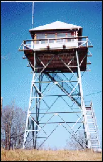
Photos keep their own rights and are shown with credit. Is one of these yours? You can ask for a different credit or for removal.
Sources
- National Historic Lookout Register (NHLR) (opens another site) Gave us: name, location, county, elevation, type, what it is built of, status, register numbers, agency, dates, photos, links National Historic Lookout Register (nhlr.org) · All rights reserved (American Resources, Inc.); facts extracted only, no prose copied. · retrieved 4 Oct 2026
- tnlandforms.us fire lookout towers (Tom Dunigan) -- GA, NC, TN (opens another site) Gave us: register numbers, links tnlandforms.us (Tom Dunigan) · No licence stated; facts only (coordinates, county, elevation, NGS/GFC/BLL register cross-references, status where given). · retrieved 4 Oct 2026
- Firefinder research Gave us: summary, design, height, status, agency, access, staffing, visiting details, dates, links, fact-check Firefinder research (sources cited in the story footnotes) · Our own research notes; each fact cites its source in the lookout's story
More about this lookout elsewhere
- NHLR register entry US 215 (nhlr.org) (opens another site)
- Cherokee County fire tower opens on limited basis for peak leaf season (Blue Ridge Public Radio) (opens another site)
- Panther Top Tower open for fall leaf views (Smoky Mountain News) (opens another site)
- Panther Top Fire Tower to be open to the public (Cherokee Co N.C. (USDA Forest Service Tusquitee Ranger District release)) (opens another site)
- Panther Top (tnlandforms.us (Tom Dunigan)) (opens another site)
Firefinder takes facts (places, dates, numbers) from these sources and writes its own words. See all sources and licences.