Fire lookout · Rockingham County, New Hampshire
Warner Hill Lookout
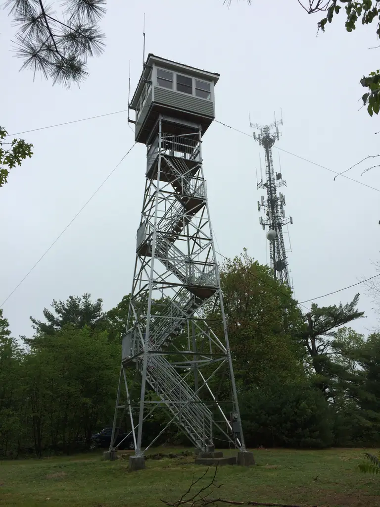
1939 International Derrick steel fire lookout on Warner Hill, Derry NH; WWII aircraft watch; state-owned and active; access sources conflict.
- Standing
- Restricted access
- Verified
Visit & stay
Not rentable. As far as we know, this lookout cannot be booked for overnight stays.
Access
Restricted access
Access is seasonal, gated or needs a permit. Check before you go. State-owned active fire tower. Register lists no signs and no staffing; Derry News says the state has closed the tower except on the most dangerous fire days but visitors can still climb to the top landing; NH Family Hikes says it is seldom visited. Check with the Division before visiting.
- Can you climb it?
- Unknown
- Road to the top?
- Yes, you can drive up
- Trail
- NH Family Hikes gives directions; Wardens Way leads 0.1 miles up to the fire tower. Public access is disputed, so check first.
- Staffing
- Unknown
Facts
- Status
- Type
- Cab on a towerSteel International Derrick tower, six tiers, with a cab added in 1979 that raised it; original height 41 feetThe design: IDECO
- Built of
- Steel
- Also served as
- Aircraft Warning Service postDuring the Second World War it was staffed to spot and report aircraft.
- Built
- 1939
- Height
- 62 ft (18.9 m)
- Elevation
- 388 ft (118 m)
- Agency
- NH Division of Forests & Lands
- Land
- Unknown
- Location
- Rockingham County, New Hampshire
- Coordinates
- 42.88568, −71.26639 sources disagree
- Registers
- This entry
- VerifiedResearched, then checked independently. Updated 8 Oct 2026.
- Firefinder id
us-nh-warner-hill
View from the cab
What you see from the cab: every ridge out to about 93 miles, the named peaks in sight, and other fire lookouts within view, worked out from terrain data in your browser.
Downloads about 3.7 MB of terrain data the first time.
Or see what it could see on the map: the ground in its line of sight.
History
Then and now
- 1939 BuiltCommissioned 1939 per register; Forest Lookouts says erected 1938-39; federal emergency funds and CCC laborSources: nhlr.org, easternuslookouts.weebly.com, historic-structures.com
- 1939 First staffedArthur Picard hired April 22, 1939 to watch from the hilltop until the tower was ready; made permanent observer after opening in early July 1939Source: derrynews.com
- 1940 EventUsed as an aircraft warning service station in the early 1940sSources: easternuslookouts.weebly.com, nhlr.org
- 1944 EventArmy left the aircraft warning station; state bought the two acres from the Mears family for $400Source: historic-structures.com
- 1950 StaffedRoscoe Smith took over as watchman starting in the 1950sSource: derrynews.com
- 1960 AlteredNew cab constructedSource: historic-structures.com
- No record between 1960 and 1979
- 1979 AlteredSixth tier added and cab raisedSource: historic-structures.com
- 1985 StaffedWalter Eaton took the watchman post around 1985Source: derrynews.com
- No record between 1985 and 2002
- 2002 Added to the National Historic Lookout RegisterRegistered March 12, 2002 as US 416, NH 17Source: nhlr.org
- 2015 RestoredBids advertised February 2015; current cab built 2015 during an extensive restorationSources: easternuslookouts.weebly.com, historic-structures.com
- 2017 AlteredMay 2017 photo shows walls removed from the lower cab; register says the tower is being remodeledSource: nhlr.org
- TodayStandingIt still stands, as far as our sources know.
Old maps of this spot
USGS topographic maps from the years a lookout stood may show it, often as a small symbol labelled “Lookout”. See the old topo maps around it on the Firefinder map, or find every scanned sheet of this spot on USGS TopoView (opens another site) (click the spot there to list them, with dates and downloads).
Story
Researched 8 Oct 2026, fact-checked.
Warner Hill rises to about 605 feet in eastern Derry, New Hampshire.1 The National Historic Lookout Register gives the elevation as 388 feet (118 m),2 while a Derry historic survey gives 604 feet.3 The 1938 hurricane caused heavy damage to forests across the state, and many thousands of trees around Derry had been toppled.4,1 The state built a steel tower on the crest with federal emergency money and Civilian Conservation Corps labor.2,4,1
Sources differ on the year. The National Historic Lookout Register says the tower was commissioned in 1939,2 while the Forest Lookouts site says an International Derrick tower was erected in 1938 and 1939.5 A Derry historic survey dates it to about 1935,3 which the other sources do not match.
Arthur Picard was hired on April 22, 1939 to watch from the hilltop until the tower was ready, and the tower opened in early July.1 Historic Structures gives its original height as 41 feet,4 while the Derry News column recalls it as about 55 feet, with a wooden cabin on top.1
During the Second World War the tower served as an aircraft warning station, given how close it was to the coast.2,4 Local volunteers, most often young married couples, kept watch there during the war.1 The Army sent five soldiers in March 1944 to take over the watch,1 then abandoned the station that year, leaving the site to the Mears family.4 The state then bought the two acres from the Mears family for $400 and removed the extra tiers.4 After Picard retired, Roscoe Smith took over in the 1950s, and Walter Eaton took the post around 1985.1
Later changes followed. A new cab went up in 1960, and in 1979 a sixth tier was added and the cab raised.4 A February 2015 call for bids covered a replacement cab, steel reinforcement and painting the tower,5 and the current cab dates from a 2015 restoration.4 A May 2017 photo on the register shows the lower cab walls had been removed, and the register says the tower was being remodeled for safety.2
Today the tower is state-owned and still in service.4,2 The register lists it as unstaffed,2 but Derry News says the state has closed the tower except on the worst fire days, and that visitors can still climb to the top landing.1 NH Family Hikes says it is seldom visited and not well advertised.6 The sources do not agree on access, so check with the Division of Forests & Lands before going, and stay off the tower if it is closed.4
- Column: Warner Hill's fire tower made for a dizzying climb, Derry News (derrynews.com), https://www.derrynews.com/opinion/column-warner-hills-fire-tower-made-for-a-dizzying-climb/article_8ff3caa9-4490-566e-8ce4-75c61f09852a.html (accessed 2026-10-08). ↩
- Warner Hill Lookout, National Historic Lookout Register (nhlr.org), http://nhlr.org/lookouts/us/nh/warner-hill-lookout/ (accessed 2026-10-08). ↩
- Warner Hill Road, Derry Public Library: Derry Historic Survey (historicsurvey.wordpress.com), https://historicsurvey.wordpress.com/2018/07/03/warner-hill-road-2/ (accessed 2026-10-08). ↩
- Warner Hill Fire Tower, Derry, New Hampshire, Historic Structures (historic-structures.com), https://www.historic-structures.com/nh/derry/warner-hill-fire-tower/ (accessed 2026-10-08). ↩
- Warner Hill - Forest Lookouts (easternuslookouts.weebly.com), https://easternuslookouts.weebly.com/warner-hill.html (accessed 2026-10-08). ↩
- Roadside Fire Towers, NH Family Hikes (nhfamilyhikes.com), http://nhfamilyhikes.com/roadsidetowers.php (accessed 2026-10-08). ↩
Photos

Photos keep their own rights and are shown with credit. Is one of these yours? You can ask for a different credit or for removal.
Where sources disagree
We show disagreements between sources instead of quietly picking one. If you know which is right, please tell us.
Sources disagree on the location by 2.2 km (1.4 mi).
- FFLA: 42.88568, −71.26639
- NHLR: 42.90211, −71.28114
They share a register number.
The map uses the position from FFLA.
Sources
- National Historic Lookout Register (NHLR) (opens another site) Gave us: name, county, elevation, what it is built of, wartime use, register numbers, agency, dates, photos, links National Historic Lookout Register (nhlr.org) · All rights reserved (American Resources, Inc.); facts extracted only, no prose copied. · retrieved 4 Oct 2026
- Forest Fire Lookout Association (FFLA) - US lookout lists (opens another site) Gave us: location, type, status, register numbers, links Forest Fire Lookout Association (firelookout.org) · No licence stated; facts extracted only, no prose copied. · retrieved 8 Oct 2026
- FOREST LOOKOUTS -- eastern US (easternuslookouts.weebly.com) (opens another site) Gave us: photos, links easternuslookouts.weebly.com · No licence stated; facts only (county, coordinates where the page's own map widget gives them, status, height, design hints, register links). The site's own historical quotes, newspaper citations and narrative are not reproduced. · retrieved 8 Oct 2026
- Firefinder research Gave us: summary, design, height, status, agency, access, visiting details, dates, links, fact-check Firefinder research (sources cited in the story footnotes) · Our own research notes; each fact cites its source in the lookout's story
More about this lookout elsewhere
- NHLR register entry US 416 (nhlr.org) (opens another site)
- NHLR register entry (nhlr.org) (opens another site)
- Column: Warner Hill's fire tower made for a dizzying climb (Derry News (derrynews.com)) (opens another site)
- Warner Hill Fire Tower, Derry, New Hampshire (Historic Structures (historic-structures.com)) (opens another site)
- Warner Hill Road (Derry Public Library: Derry Historic Survey (historicsurvey.wordpress.com)) (opens another site)
- Roadside Fire Towers (NH Family Hikes (nhfamilyhikes.com)) (opens another site)
- FFLA New Hampshire lookout list (firelookout.org) (opens another site)
- Warner Hill (easternuslookouts.weebly.com) (opens another site)
Firefinder takes facts (places, dates, numbers) from these sources and writes its own words. See all sources and licences.