Fire lookout · Ocean County, New Jersey
Cedar Bridge Fire Tower
Ocean County tower erected in 1924 was gone from its first site by 1938 (records differ on torn down vs moved); moved to its present Route 539 site around 1983; still active.
- Standing
- Restricted access
- Verified
Visit & stay
Not rentable. As far as we know, this lookout cannot be booked for overnight stays.
Access
Restricted access
Access is seasonal, gated or needs a permit. Check before you go. Fenced in with a locked gate at the 2004 visit. Active fire-service tower beside County Route 539.
- Can you climb it?
- Unknown
- Road to the top?
- Unknown
- Trail
- No visiting directions confirmed. The register's access checklist asks whether directions are signed without recording an answer. The 2004 visit found the tower fenced with a locked gate.
- Staffing
- Unknown
Facts
- Status
- Type
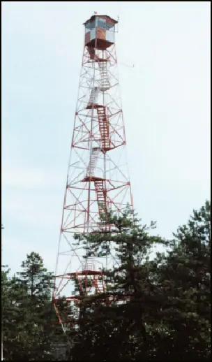
- Cab on a tower100-ft International Derrick steel tower with 7'x7' metal cabThe design: IDECO
- Built of
- SteelGoing by its design; no source says so in words.
- Built
- 1924
- Height
- 98 ft (30.0 m)
- Elevation
- 177 ft (54 m)
- Agency
- New Jersey Forest Fire Service
- Land
- State land
- Location
- Ocean County, New Jersey
- Coordinates
- 39.83967, −74.38060
- Registers
- This entry
- VerifiedResearched, then checked independently. Updated 8 Oct 2026.
- Firefinder id
us-nj-cedar-bridge
View from the cab
What you see from the cab: every ridge out to about 93 miles, the named peaks in sight, and other fire lookouts within view, worked out from terrain data in your browser.
Downloads about 3.4 MB of terrain data the first time.
Or see what it could see on the map: the ground in its line of sight.
History
Then and now
- 1924 BuiltOriginal 60-ft Aermotor lookout; the register says it stood seven miles south of the present siteSources: nhlr.org, njpinebarrens.com
- 1938 AbandonedNewspaper item of July 8, 1938 calls the tower abandonedSource: easternuslookouts.weebly.com
- 1938 MovedMoved across the county line into Burlington County, per a 1951 visit; a 1950 survey note quoting state records says it was torn downSource: njpinebarrens.com
- 1942 MovedBelieved taken down about 1942 and possibly re-erected at Old Bridge, per an unpublished manuscript as quoted; not confirmedSource: njpinebarrens.com
- No record between 1942 and 1983
- 1983 MovedHelicopter move about one mile to the present site on County Route 539Sources: nhlr.org, njpinebarrens.com
- 1997 Added to the National Historic Lookout RegisterRegistered December 15, 1997 as US 248, NJ 10Source: nhlr.org
- TodayStandingIt still stands, as far as our sources know.
Old maps of this spot
USGS topographic maps from the years a lookout stood may show it, often as a small symbol labelled “Lookout”. See the old topo maps around it on the Firefinder map, or find every scanned sheet of this spot on USGS TopoView (opens another site) (click the spot there to list them, with dates and downloads).
Story
Researched 8 Oct 2026, fact-checked.
The Cedar Bridge Fire Tower has been moved three times since a 60-foot lookout first went up in 1924.1 The register places that original tower seven miles south of its present site, while a local history site puts the first lookout on a small knoll near the Cedar Bridge Hotel.1,2
A July 1938 newspaper item already described an "abandoned fire lookout tower at Cedar Bridge."3 Sources then disagree on what became of it.2,3 A 1950 survey note, citing state forestry records, said the tower was torn down in 1938.2 A 1951 visit instead found that it had been moved across the county line into Burlington County in 1938.2
The history site, citing an unpublished manuscript by a fire-tower historian, says the Burlington County tower was taken down around 1942 and may have been re-erected at Old Bridge.2 A new 110-foot International Derrick tower followed, on a sand road toward the Forked River Mountains.2 The history site says it had a flat roof with a railing and no electricity.2
The remote site was vandalized in the 1970s and early 1980s, so it was decided to move the tower again.2 Around 1983 a helicopter carried it about a mile to its present spot on County Route 539.1,2
Accounts differ on the roof.1,2 The register says the tower fell over years ago, damaging its original roof, and that the forest service later put on a more traditional peaked roof.1 The history site first describes a flat roof, then says an unusual gable roof was removed during the 1983 move.2
Today the tower stands 100 feet tall and is still in active service.2,1 A 2004 visit report found it fenced in behind a locked gate and said it was usually manned during fire seasons.1 We found no newer staffing or public-access information.1 Treat it as an active state fire tower and stay behind the fence unless the agency says otherwise.1
- Cedar Bridge Fire Tower, National Historic Lookout Register, http://nhlr.org/lookouts/us/nj/cedar-bridge-fire-tower/ (accessed 2026-10-08). ↩
- The History of the Cedar Bridge Fire Tower, NJPineBarrens.com, https://www.njpinebarrens.com/the-history-of-the-cedar-bridge-fire-tower/ (accessed 2026-10-08). ↩
- Cedar Bridge - Forest Lookouts, Forest Lookouts, https://easternuslookouts.weebly.com/cedar-bridge.html (accessed 2026-10-08). ↩
Photos
Photos keep their own rights and are shown with credit. Is one of these yours? You can ask for a different credit or for removal.
Sources
- National Historic Lookout Register (NHLR) (opens another site) Gave us: name, location, county, elevation, type, what it is built of, status, register numbers, agency, dates, photos, links National Historic Lookout Register (nhlr.org) · All rights reserved (American Resources, Inc.); facts extracted only, no prose copied. · retrieved 4 Oct 2026
- Wikipedia: List of New Jersey Forest Fire Service fire towers (opens another site) Gave us: height, ownership, links Wikipedia (NJFFS fire tower list) · CC BY-SA 4.0 (Wikipedia). Facts only (register numbers, elevation, height, division, coordinates); article prose/notes not reproduced. Photos are Wikimedia Commons files, each with its own licence on its file page. · retrieved 4 Oct 2026
- FOREST LOOKOUTS -- eastern US (easternuslookouts.weebly.com) (opens another site) Gave us: links easternuslookouts.weebly.com · No licence stated; facts only (county, coordinates where the page's own map widget gives them, status, height, design hints, register links). The site's own historical quotes, newspaper citations and narrative are not reproduced. · retrieved 8 Oct 2026
- OpenStreetMap -- fire lookout structures (opens another site) Gave us: links © OpenStreetMap contributors · ODbL 1.0. (c) OpenStreetMap contributors. · retrieved 4 Oct 2026
- Firefinder research Gave us: summary, design, height, status, agency, access, visiting details, dates, links, fact-check Firefinder research (sources cited in the story footnotes) · Our own research notes; each fact cites its source in the lookout's story
More about this lookout elsewhere
- NHLR register entry US 248 (nhlr.org) (opens another site)
- The History of the Cedar Bridge Fire Tower (NJPineBarrens.com) (opens another site)
- Cedar Bridge Station (Wikipedia (List of New Jersey Forest Fire Service fire towers)) (opens another site)
- Cedar Bridge (easternuslookouts.weebly.com) (opens another site)
- OpenStreetMap node 5579305023 (opens another site)
Firefinder takes facts (places, dates, numbers) from these sources and writes its own words. See all sources and licences.