Fire lookout · Burlington County, New Jersey
Medford Station Fire Tower
Planned in 1940 and built in 1948 as a 100-foot Aermotor tower at Piper's Corner, Burlington County; still in service, with a staffed observer described in 2026.
- Standing
- Restricted access
- Verified
Visit & stay
Not rentable. As far as we know, this lookout cannot be booked for overnight stays.
Access
Restricted access
Access is seasonal, gated or needs a permit. Check before you go. Working NJFFS observation post; a 2026 WHYY report describes a staffed observer on duty, and no source read describes public climbing.
- Can you climb it?
- Unknown
- Road to the top?
- Unknown
- Staffing
- Staffed during fire season (as of 2026-06-09)
Facts
- Status
- Type
- Cab on a tower100-foot Aermotor tower with a 7x7-foot metal cabThe design: Aermotor
- Built of
- SteelGoing by its design; no source says so in words.
- Built
- 1948
- Height
- 98 ft (30.0 m)
- Elevation
- 141 ft (43 m)
- Agency
- New Jersey Forest Fire Service
- Land
- State land
- Location
- Burlington County, New Jersey
- Coordinates
- 39.84173, −74.78958
- Registers
- This entry
- VerifiedResearched, then checked independently. Updated 8 Oct 2026.
- Firefinder id
us-nj-medford
View from the cab
What you see from the cab: every ridge out to about 93 miles, the named peaks in sight, and other fire lookouts within view, worked out from terrain data in your browser.
Downloads about 3.6 MB of terrain data the first time.
Or see what it could see on the map: the ground in its line of sight.
History
Then and now
- 1940 EventPlans for the tower were set in 1940, per the NHLR pageSource: nhlr.org
- 1948 BuiltConstruction in 1948 after World War II; 1948 newspaper says it was being erected by Corlen Engineering Co. of Collingswood for about $4,500Sources: nhlr.org, easternuslookouts.weebly.com
- No record between 1948 and 2004
- 2004 Added to the National Historic Lookout RegisterRegistered March 15, 2004Source: nhlr.org
- TodayStandingIt still stands, as far as our sources know.
Old maps of this spot
USGS topographic maps from the years a lookout stood may show it, often as a small symbol labelled “Lookout”. See the old topo maps around it on the Firefinder map, or find every scanned sheet of this spot on USGS TopoView (opens another site) (click the spot there to list them, with dates and downloads).
Story
Researched 8 Oct 2026, fact-checked.
The Medford Station fire tower stands at Piper's Corner in Burlington County, New Jersey.1,2 Plans were set in 1940, but construction waited until after World War II, and the tower went up in 1948.1 A May 1948 newspaper item, reprinted on a lookout history site, said the Forest Fire Service was putting up a 100-foot steel tower by Piper's Corner, in the Medford Lakes area.3 Corlen Engineering Co. of Collingswood was building it for about $4,500.3
The new tower was meant to supplement a 60-foot tower at Retreat, in Southampton Township.3 It was also meant to shield owners of property around Medford Lakes from pine-country fires.3
The register describes a 100-foot Aermotor tower with a 7-by-7-foot metal cab, gives its elevation as 141 feet, and records it as in active service.1 It was registered on March 15, 2004.1 Wikipedia's list gives the same height of 100 feet (30 m) and elevation of 141 feet.4
A WHYY report updated June 9, 2026 says the tower has been in use since 1948 and is one of 21 towers statewide.5 The article describes an observer who climbs 150 metal stairs to a 7-by-7-foot office at the top each morning and spends eight hours a day watching for smoke.5 WHYY places the tower above Wharton State Forest, while the register and the Division B page name Piper's Corner. The sources do not conflict outright, but the wording differs.5,1,2
The Division B page lists the tower at Piper's Corner, with an elevation of 141 feet.2 No source read for this story describes public visits. The tower is a staffed state post, so it should be treated as one and not as a place to climb.5,2
- Medford Station Fire Tower, National Historic Lookout Register, http://nhlr.org/lookouts/us/nj/medford-station-fire-tower/ (accessed 2026-10-08). ↩
- Div B Fire Towers, NJFFS Section B10, https://www.sectionb10.org/firetowers (accessed 2026-10-08). ↩
- Medford - Forest Lookouts, Forest Lookouts, https://easternuslookouts.weebly.com/medford.html (accessed 2026-10-08). ↩
- List of New Jersey Forest Fire Service fire towers, Wikipedia, https://en.wikipedia.org/wiki/List_of_New_Jersey_Forest_Fire_Service_fire_towers (accessed 2026-10-08). ↩
- NJ wildfires: In the AI era, the Forest Service relies on humans, WHYY, https://whyy.org/articles/new-jersey-pine-barrens-fire-service-tower/ (accessed 2026-10-08). ↩
Photos
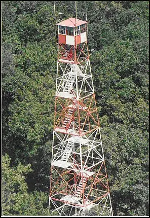
Photos keep their own rights and are shown with credit. Is one of these yours? You can ask for a different credit or for removal.
Sources
- National Historic Lookout Register (NHLR) (opens another site) Gave us: name, location, county, elevation, type, what it is built of, status, register numbers, agency, dates, photos, links National Historic Lookout Register (nhlr.org) · All rights reserved (American Resources, Inc.); facts extracted only, no prose copied. · retrieved 4 Oct 2026
- Wikipedia: List of New Jersey Forest Fire Service fire towers (opens another site) Gave us: height, ownership, links Wikipedia (NJFFS fire tower list) · CC BY-SA 4.0 (Wikipedia). Facts only (register numbers, elevation, height, division, coordinates); article prose/notes not reproduced. Photos are Wikimedia Commons files, each with its own licence on its file page. · retrieved 4 Oct 2026
- FOREST LOOKOUTS -- eastern US (easternuslookouts.weebly.com) (opens another site) Gave us: links easternuslookouts.weebly.com · No licence stated; facts only (county, coordinates where the page's own map widget gives them, status, height, design hints, register links). The site's own historical quotes, newspaper citations and narrative are not reproduced. · retrieved 8 Oct 2026
- OpenStreetMap -- fire lookout structures (opens another site) Gave us: links © OpenStreetMap contributors · ODbL 1.0. (c) OpenStreetMap contributors. · retrieved 4 Oct 2026
- Firefinder research Gave us: summary, design, height, status, agency, access, staffing, dates, links, fact-check Firefinder research (sources cited in the story footnotes) · Our own research notes; each fact cites its source in the lookout's story
More about this lookout elsewhere
- NHLR register entry US 568 (nhlr.org) (opens another site)
- NJ wildfires: In the AI era, the Forest Service relies on humans (WHYY) (opens another site)
- Div B Fire Towers (NJFFS Section B10) (opens another site)
- Medford Station (Wikipedia (List of New Jersey Forest Fire Service fire towers)) (opens another site)
- Medford (easternuslookouts.weebly.com) (opens another site)
- OpenStreetMap node 5579305024 (opens another site)
Firefinder takes facts (places, dates, numbers) from these sources and writes its own words. See all sources and licences.