Fire lookout · Torrance County, New Mexico
Capilla Peak Lookout
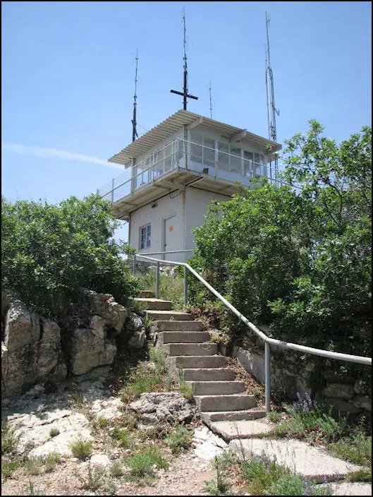
A 1963 steel CL-100 cab on a block base in the Cibola National Forest, first staffed in 1922. Closed to visitors under a Forest Service order reported through October 31, 2026.
- Standing
- Closed
- Verified
Closed
The site is closed to visitors. Forest Service road and area closure order covers the road from the forest boundary to the lookout and the campground. Reported to last until October 31, 2026, while summit observatory buildings are removed.
Visit & stay
Not rentable. As far as we know, this lookout cannot be booked for overnight stays.
Access
Closed. See the warning at the top of this page.
- Can you climb it?
- Unknown
- Road to the top?
- Unknown
- Staffing
- Unknown
Facts
- Status
- Type
- Two-story buildingCL-100 all-steel cab on a block base about ten feet high, erected 1963; replaced an earlier frame cab similar to the L-4 designThe designs: CL-100, L-4
- Built of
- Not recorded
- Built
- 1922 sources disagree
- Height
- Unknown
- Elevation
- 9,368 ft (2,855 m)
- Agency
- U.S. Forest Service (Cibola National Forest, Mountainair Ranger District)
- Land
- Federal land
- Location
- Torrance County, New Mexico
- Coordinates
- 34.70140, −106.40100
- Registers
- This entry
- VerifiedResearched, then checked independently. Updated 8 Oct 2026.
- Firefinder id
us-nm-capilla-peak
View from the cab
What you see from the cab: every ridge out to about 93 miles, the named peaks in sight, and other fire lookouts within view, worked out from terrain data in your browser.
Downloads about 2.8 MB of terrain data the first time.
Or see what it could see on the map: the ground in its line of sight.
History
Then and now
- 1922 BuiltFirst lookout cabin, L-4 style, erected on the peakSources: nhlr.org, westlookouts.weebly.com
- 1922 First staffedC.A. Finley stationed on the peak as a lookout in June 1922Source: westlookouts.weebly.com
- 1934 FireCapilla Peak lookout sighted a fire near Chilili that burned about a hundred acresSource: westlookouts.weebly.com
- 1938 StaffedRanger Marvin Johnson and his wife, Colleen, reported stationed at the lookoutSource: westlookouts.weebly.com
- 1940 ClosedLookout station closed after heavy rains eliminated fire danger in the regionSource: westlookouts.weebly.com
- No record between 1940 and 1963
- 1963 Built'Built' field on NHLR detail pageSource: NHLR register entry
- 1963 Replaced by a new structurePresent CL-100 all-steel cab erected on a block base, replacing the earlier frame cabSources: nhlr.org, westlookouts.weebly.com
- No record between 1963 and 2007
- 2007 Added to the National Historic Lookout RegisterRegistered on the National Historic Lookout Register, June 17, 2007Source: nhlr.org
- No record between 2007 and 2026
- 2026 ClosedRoad and area closure order from the forest boundary to the lookout, expected to last until October 31, 2026, while UNM observatory buildings on the summit are demolishedSources: fs.usda.gov, krqe.com
- TodayStandingIt still stands, as far as our sources know.
Old maps of this spot
USGS topographic maps from the years a lookout stood may show it, often as a small symbol labelled “Lookout”. See the old topo maps around it on the Firefinder map, or find every scanned sheet of this spot on USGS TopoView (opens another site) (click the spot there to list them, with dates and downloads).
Story
Researched 8 Oct 2026, fact-checked.
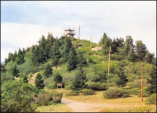
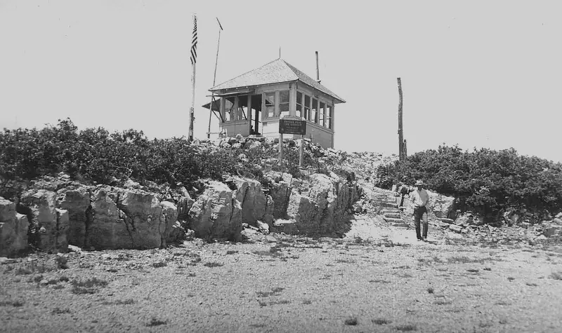
Capilla Peak, in the Cibola National Forest near the Manzano Mountains, got its first fire lookout in 1922.1,2,3 Early newspaper clips spell the name "Capillo Peak."2 In May 1922 the Forest Service said it was preparing to give up its Bosque station and put one on the peak instead, and by June a lookout had been posted there.2 The first spotters went up on horseback, and pack mules hauled in building materials for the cabin.1
That first building was a small cabin in the L-4 style.1,2 In 1963 the Forest Service replaced it with the steel CL-100 cab that stands there now.1,2 The cab sits on a block base about ten feet high, which was meant as storage space.1,2
The lookout was staffed during the 1930s.2 In June 1934 the Capilla Peak lookout sighted a fire near Chilili, which burned about a hundred acres before it was brought under control.2 A 1938 report named Ranger Marvin Johnson and his wife, Colleen, as stationed there.2 In August 1940 the station was closed because heavy rains had ended the fire danger in that region.2 The lookout was added to the National Historic Lookout Register on June 17, 2007.1
It is not open to visitors at the moment.3,4 A Forest Service closure order covers the road from the forest boundary to the lookout, along with the campground.3,4 The order was reported to run until October 31, 2026, while the old University of New Mexico observatory buildings on the summit are taken down.4 Please stay out of the closed area, and check with the Mountainair Ranger District before planning any trip. I did not find current staffing information for the lookout.
- Capilla Peak Lookout, National Historic Lookout Register, http://nhlr.org/lookouts/us/nm/capilla-peak-lookout/ (accessed 2026-10-08). ↩
- Capilla Peak, Forest Lookouts (westlookouts), https://westlookouts.weebly.com/capilla-peak.html (accessed 2026-10-08). ↩
- Capilla Peak Campground, Cibola National Forest and National Grasslands, https://www.fs.usda.gov/r03/cibola/recreation/capilla-peak-campground (accessed 2026-10-08). ↩
- Capilla peak lookout area and road closed, KRQE News 13, https://www.krqe.com/news/new-mexico/cibola-national-forest-national-grasslands-temporarily-closes-road-near-capilla-peak-lookout/ (accessed 2026-10-08). ↩
Photos
Photos keep their own rights and are shown with credit. Is one of these yours? You can ask for a different credit or for removal.
Where sources disagree
We show disagreements between sources instead of quietly picking one. If you know which is right, please tell us.
Sources disagree on the year it was built.
- NHLR: 1963
- Forest Fire Lookout Association chapter reports: 1960
Sources give different build years. Often one counts the first lookout on the site and another the structure there now.
Sources
- National Historic Lookout Register (NHLR) (opens another site) Gave us: name, location, county, elevation, register numbers, agency, ownership, dates, photos, links National Historic Lookout Register (nhlr.org) · All rights reserved (American Resources, Inc.); facts extracted only, no prose copied. · retrieved 4 Oct 2026
- Forest Fire Lookout Association (FFLA) - US lookout lists (opens another site) Gave us: type, status, register numbers, links Forest Fire Lookout Association (firelookout.org) · No licence stated; facts extracted only, no prose copied. · retrieved 8 Oct 2026
- Forest Fire Lookout Association chapter reports (opens another site) Gave us: design, links Forest Fire Lookout Association, chapter and restoration-grant reports (firelookout.org) · No licence stated; facts only (dates, names, the kind of work done). Every note is our own wording and every event links to the FFLA report it comes from. Positions are copied from the NHLR, FFLOS and FFLA records. · retrieved 8 Oct 2026
- OpenStreetMap -- fire lookout structures (opens another site) Gave us: links © OpenStreetMap contributors · ODbL 1.0. (c) OpenStreetMap contributors. · retrieved 4 Oct 2026
- Firefinder research Gave us: summary, design, agency, access, dates, links, fact-check Firefinder research (sources cited in the story footnotes) · Our own research notes; each fact cites its source in the lookout's story
More about this lookout elsewhere
- NHLR register entry US 695 (nhlr.org) (opens another site)
- Capilla Peak (Forest Lookouts (westlookouts)) (opens another site)
- Capilla Peak Campground (Cibola National Forest and National Grasslands, U.S. Forest Service) (opens another site)
- Capilla peak lookout area and road closed (KRQE News 13) (opens another site)
- FFLA New Mexico lookout list (firelookout.org) (opens another site)
- Forest Fire Lookout Association chapter reports: work on Capilla Peak Lookout (opens another site)
- Wikidata item Q86868077 (opens another site)
- OpenStreetMap node 7260068232 (opens another site)
Firefinder takes facts (places, dates, numbers) from these sources and writes its own words. See all sources and licences.