Fire lookout · Rio Arriba County, New Mexico
Clara Peak Lookout Site
Santa Fe National Forest lookout built in 1951 with a cinder-block L-4 cab; staffed into the 1980s and demolished in 1993 or 1994.
- Gone
- Access unknown
- Verified
Gone: The lookout no longer stands. Only the site is left. Demolished in 1993 or 1994, according to the Forest history.
Visit & stay
Gone: site only. The lookout no longer stands, so there is nothing to climb or rent.
Access
Access unknown
We do not know the access rules. Check with the land manager before you go.
- Road to the top?
- Yes, you can drive up
- Trail
- Unpaved road of about 3.1 miles from State Highway 565 (31 Miles Road), not plowed in winter; the road guide suggests parking about a quarter mile from the peak and hiking the rest unless the vehicle is rugged.
Facts
- Status
- Type
- Ground-level cab14 by 14 ft modified L-4 ground house of cinder block (register: stuccoed cinderblocks)The design: L-4
- Built of
- WoodGoing by its design; no source says so in words.
- Built
- 1951
- Height
- Unknown
- Elevation
- 8,551 ft (2,606 m)
- Agency
- Santa Fe National Forest
- Land
- Federal land
- Location
- Rio Arriba County, New Mexico
- Coordinates
- 36.03570, −106.24040
- Registers
- This entry
- VerifiedResearched, then checked independently. Updated 9 Oct 2026.
- Firefinder id
us-nm-clara-peak
View from the cab
What the lookout saw from its cab: every ridge out to about 93 miles, the named peaks in sight, and other fire lookouts within view, worked out from terrain data in your browser.
This lookout is gone. The view is reconstructed from its recorded site and a typical height for a lookout like it.
Downloads about 3.2 MB of terrain data the first time.
Or see what it could see on the map: the ground in its line of sight.
History
Then and now
- 1951 BuiltBuilt under a 1951 cooperative agreement among the Forest, the SCS and the Indian Service; 14 by 14 ft L-4 ground houseSources: npshistory.com, firetower.org
- 1962 StaffedApollinario (Paul) Trujillo staffed the lookout from 1962 to 1975, with his wife Adelires as reliefSource: npshistory.com
- No record between 1962 and 1984
- 1984 StaffedRegularly staffed through 1984; wet summers and Los Alamos detection methods reduced staffing in the late 1980sSource: npshistory.com
- 1993 RemovedDemolished in 1993 or 1994 per the Forest history; the road guide gives the winter of 1993-1994; the register gives only a 1988 to 2015 windowSources: npshistory.com, firetower.org, dangerousroads.org
- No record between 1993 and 2015
- 2015 Added to the Former Fire Lookout Sites RegisterRegistered on the Former Fire Lookout Sites register on August 30, 2015Source: firetower.org
- TodayGoneThe lookout no longer stands. Only the site is left.
Old maps of this spot
USGS topographic maps from the years a lookout stood may show it, often as a small symbol labelled “Lookout”. See the old topo maps around it on the Firefinder map, or find every scanned sheet of this spot on USGS TopoView (opens another site) (click the spot there to list them, with dates and downloads).
Story
Researched 9 Oct 2026, fact-checked.
Clara Peak Lookout stood on the Espanola Ranger District of the Santa Fe National Forest, in Rio Arriba County, New Mexico.1 The Forest history says the Forest built Encino Lookout in 1950 and Clara Peak in 1951, and that these were the last lookouts it erected on new sites.2
Under a 1951 cooperative agreement, the Forest supplied fire protection for the area, and the SCS and the Indian Service covered a large share of the building cost.2 The register describes the cabin as a 14-by-14-foot L-4 ground house of stuccoed cinder block.1 The register says the outhouse, storage shed and cistern went up with the lookout.1 The Forest history says the storage shed was moved from Puye Lookout, so the two sources disagree on that point.2
Apollinario (Paul) Trujillo manned Clara Peak from 1962 to 1975, and his wife, Adelires, served as relief.2 The history says the lookout was regularly staffed through 1984.2 A run of wet summers, and the Los Alamos National Laboratory developing its own ways of detecting smokes, led to reduced staffing in the late 1980s.2
The Forest history says the laboratory reportedly developed other detection methods, which ended its reliance on the lookout and contributed to its closure.2 The register only brackets the removal, placing it somewhere between 1988 and 2015.1 The Forest history says the lookout was demolished in 1993 or 1994.2 A road guide dates the demolition to the winter of 1993-1994.3
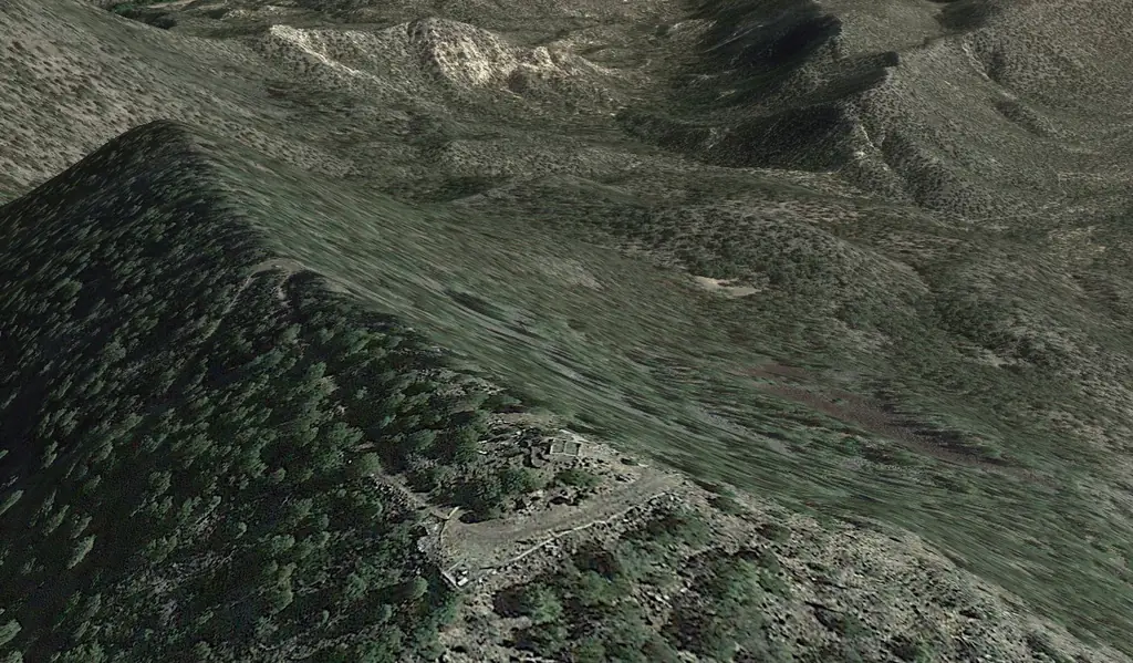
The register includes a Google Earth view labeled as imagery of ruins, and no source we read describes the site in more detail.1 The road to the summit starts at State Highway 565, which the road guide calls 31 Miles Road, and runs about 3.1 miles.3 The road is unpaved and set high in the Jemez Mountains, and it is not plowed in winter.3 The guide suggests that drivers stop about a quarter mile from the peak and hike the rest, unless their vehicle is rugged and has good clearance.3 Check with the Santa Fe National Forest before you drive up.
- Clara Peak Lookout Site, Former Fire Lookout Sites Register, http://firetower.org/lookouts/us/nm/clara-peak-lookout-site/ (accessed 2026-10-09). ↩
- Fire Lookout History of the Santa Fe National Forest, USDA Forest Service, Santa Fe National Forest, https://npshistory.com/publications/usfs/region/3/santa-fe/fire-lookout-history.pdf (accessed 2026-10-09). ↩
- How to drive the unpaved road to Clara Peak in New Mexico, Dangerous Roads, https://www.dangerousroads.org/north-america/usa/7021-clara-peak.html (accessed 2026-10-09). ↩
Photos
Photos keep their own rights and are shown with credit. Is one of these yours? You can ask for a different credit or for removal.
Sources
- Former Fire Lookout Sites Register (FFLOS) (opens another site) Gave us: name, location, county, elevation, what it is built of, register numbers, agency, ownership, dates, photos, links Former Fire Lookout Sites Register (firetower.org) · All rights reserved (American Resources, Inc.); facts extracted only, no prose copied. · retrieved 4 Oct 2026
- Forest Fire Lookout Association (FFLA) - US lookout lists (opens another site) Gave us: type, status, register numbers, links Forest Fire Lookout Association (firelookout.org) · No licence stated; facts extracted only, no prose copied. · retrieved 8 Oct 2026
- FOREST LOOKOUTS -- western US (Ron Kemnow's weebly sites) (opens another site) Gave us: links Ron Kemnow's Forest Lookouts sites (westlookouts, californialookouts, idaholookouts, montanalookouts, oregonlookouts and washingtonlookouts .weebly.com) · No licence stated; facts only (county, land manager, status word, coordinates where the page's own map widget gives them, township-range-section, height and design hints, links). The site's own newspaper quotes, citations and narrative are not reproduced. · retrieved 8 Oct 2026
- Firefinder research Gave us: summary, design, status, agency, visiting details, dates, links, fact-check Firefinder research (sources cited in the story footnotes) · Our own research notes; each fact cites its source in the lookout's story
More about this lookout elsewhere
- FFLOS register entry US 1603 (firetower.org) (opens another site)
- Fire Lookout History of the Santa Fe National Forest (USDA Forest Service, Santa Fe National Forest (hosted by npshistory.com)) (opens another site)
- How to drive the unpaved road to Clara Peak in New Mexico (Dangerous Roads) (opens another site)
- FFLA New Mexico lookout list (firelookout.org) (opens another site)
- Clara Peak on Forest Lookouts, western US (Ron Kemnow) (opens another site)
Firefinder takes facts (places, dates, numbers) from these sources and writes its own words. See all sources and licences.