Fire lookout · Douglas County, Nevada
Zephyr Point (Zephyr Cove) Lookout
Also known as Zephyr Point
The last Forest Service lookout remaining in Nevada, a 1931-32 4AR cab above Lake Tahoe now on private land, leased for cell antennas since 1997 and once proposed for a move to White Hill.
- Standing
- Private land
- Verified
Private land
No public access. Please do not trespass; view it only from public land. Sits on a 1.1-acre private parcel owned by Zephyr Cove Properties; the Forest Service holds only a right-of-way easement. Not open to public visitation at this site as of the sources checked.
Visit & stay
Not rentable. As far as we know, this lookout cannot be booked for overnight stays.
Access
Private land. See the warning at the top of this page.
- Can you climb it?
- No
- Road to the top?
- Unknown
- Staffing
- Not staffed (as of 2001)
Facts
- Status
- Type
- Enclosed tower4AR-style enclosed cab, one of twelve surviving nationwideThe design: D-5 (4-AR)
- Built of
- Not recorded
- Built
- 1931
- Height
- 29 ft (8.8 m)
- Elevation
- 6,348 ft (1,935 m)
- Agency
- U.S. Forest Service (historic administrator; land now privately owned)
- Land
- Federal land
- Location
- Douglas County, Nevada
- Coordinates
- 39.00055, −119.95223
- Registers
- This entry
- VerifiedResearched, then checked independently. Updated 8 Oct 2026.
- Firefinder id
us-nv-zephyr-point-zephyr-cove
View from the cab
What you see from the cab: every ridge out to about 93 miles, the named peaks in sight, and other fire lookouts within view, worked out from terrain data in your browser.
Downloads about 3.4 MB of terrain data the first time.
Or see what it could see on the map: the ground in its line of sight.
History
Then and now
- 1931 BuiltConstruction began winter 1931, funded partly by local supporter A. K. Bourne ($1,500) and Douglas County (road access). The National Historic Lookout Register gives the completed build year as 1932.Sources: westlookouts.weebly.com, nhlr.org
- No record between 1931 and 1954
- 1954 Last staffedU.S. Forest Service staffing ended in 1954 when the Nevada Division of Forestry took over operation. The tower closed for the season in October 1964 and continued in use afterward; one source describes it as the last lookout NDF still operated in western Nevada, into the 1970s.Sources: westlookouts.weebly.com, tahoedailytribune.com
- No record between 1954 and 1998
- 1998 Added to the National Historic Lookout RegisterListed on the National Historic Lookout Register October 8, 1998, as US 278 / NV 1; nominated by Mark Swift. Found NRHP-eligible in 1997 (a separate, earlier determination reported only by the South Tahoe Now article).Sources: nhlr.org, southtahoenow.com
- TodayStandingIt still stands, as far as our sources know.
Old maps of this spot
USGS topographic maps from the years a lookout stood may show it, often as a small symbol labelled “Lookout”. See the old topo maps around it on the Firefinder map, or find every scanned sheet of this spot on USGS TopoView (opens another site) (click the spot there to list them, with dates and downloads).
Story
Researched 4 Oct 2026, fact-checked.
Zephyr Point (Zephyr Cove) Lookout
Zephyr Point stands above Lake Tahoe's southeast shore in Douglas County, Nevada, the last Forest Service lookout remaining in the state.1 Construction began in the winter of 1931, with road access paid for by Douglas County and $1,500 toward the building itself contributed by a local supporter, A. K. Bourne; the National Historic Lookout Register gives the finished build year as 1932.2,1 The tower is built to the 4AR cab plan, one of only twelve such cabs still standing nationwide — six in California, two each in Oregon and Arizona, and one each in Idaho and Nevada.1 The cab is 14 feet square, rises 29 feet on its foundation, has a pyramid roof and banks of windows on the upper floor, and an exterior catwalk with a railing; inside was a bed, table, stove and sink upstairs, and bunk beds, a water heater and a bathroom downstairs.3
A Forest Service ranger named Buck Wheeler oversaw the station in its early years. Jim Cain was serving as fire warden by 1941, and in 1940 the husband of a Mrs. T. C. Clifton staffed the tower for a summer.2 From the cab, lookouts spotted at least two fires that might otherwise have grown unchecked: a lightning strike in 1936 and a firecracker-caused blaze in 1941.2
The Forest Service ran Zephyr Point until 1954, when the Nevada Division of Forestry took it over.3 Idaho schoolteachers Leonard and Margaret Hoff spent the summers of 1955–56 and 1958 there.3 The tower closed for the season in October 1964, and it went on being used — by one account the last lookout the Division of Forestry still operated in western Nevada — into the 1970s.2,3
At some point the lookout passed out of Forest Service ownership. It now sits on a 1.1-acre private parcel owned by Zephyr Cove Properties, with the Forest Service holding only a right-of-way easement for access.3 Starting in 1997, Pacific Bell Wireless leased the tower to mount cellular antennas, paying over $2,600 a year and investing $20,000 in upgrades; the building no longer functions as a fire lookout.3 That same year the structure was determined eligible for the National Register of Historic Places.4 The following year, on October 8, 1998, it was listed on the National Historic Lookout Register as US 278 / NV 1, nominated by Mark Swift.1
In November 2013 the Forest Service's Lake Tahoe Basin Management Unit proposed dismantling the tower and trucking it to a new site atop White Hill, above Spooner Summit, to restore a public-access fire-watch view that development around the original site had closed off.4 Whether that move was ever carried out could not be confirmed from the sources checked for this story. Visitors should not assume the tower still stands at its original Zephyr Heights site, or that it is open to the public; it is private land, reached only by a Forest Service easement, and climbing it has not been established as safe or permitted.
- Zephyr Point (Zephyr Cove) Lookout, National Historic Lookout Register, http://nhlr.org/lookouts/us/nv/zephyr-point-zephyr-cove-lookout/ (accessed 2026-10-04). ↩
- Zephyr Point, FOREST LOOKOUTS (West), https://westlookouts.weebly.com/zephyr-point.html (accessed 2026-10-04). ↩
- Zephyr Cove lookout seen as historical, Tahoe Daily Tribune, https://www.tahoedailytribune.com/news/zephyr-cove-lookout-seen-as-historical/ (accessed 2026-10-04). ↩
- Forest Service proposes to relocate Zephyr Point Lookout, South Tahoe Now, http://southtahoenow.com/story/11/13/2013/forest-service-proposes-relocate-zephyr-point-lookout (accessed 2026-10-04). ↩
Photos
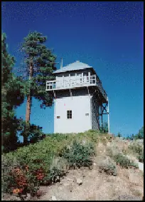
Photos keep their own rights and are shown with credit. Is one of these yours? You can ask for a different credit or for removal.
Sources
- National Historic Lookout Register (NHLR) (opens another site) Gave us: name, location, county, elevation, register numbers, agency, ownership, dates, photos, links National Historic Lookout Register (nhlr.org) · All rights reserved (American Resources, Inc.); facts extracted only, no prose copied. · retrieved 4 Oct 2026
- Forest Fire Lookout Association (FFLA) - US lookout lists (opens another site) Gave us: type, status, register numbers, links Forest Fire Lookout Association (firelookout.org) · No licence stated; facts extracted only, no prose copied. · retrieved 8 Oct 2026
- Forest Fire Lookout Association (FFLA) - US lookout lists (opens another site) Gave us: register numbers Forest Fire Lookout Association (firelookout.org) · No licence stated; facts extracted only, no prose copied. · retrieved 8 Oct 2026
- Forest Fire Lookout Association (FFLA) - US lookout lists (opens another site) Gave us: register numbers Forest Fire Lookout Association (firelookout.org) · No licence stated; facts extracted only, no prose copied. · retrieved 8 Oct 2026
- Forest Fire Lookout Association chapter reports (opens another site) Gave us: dates, links Forest Fire Lookout Association, chapter and restoration-grant reports (firelookout.org) · No licence stated; facts only (dates, names, the kind of work done). Every note is our own wording and every event links to the FFLA report it comes from. Positions are copied from the NHLR, FFLOS and FFLA records. · retrieved 8 Oct 2026
- FOREST LOOKOUTS -- western US (Ron Kemnow's weebly sites) (opens another site) Gave us: links Ron Kemnow's Forest Lookouts sites (westlookouts, californialookouts, idaholookouts, montanalookouts, oregonlookouts and washingtonlookouts .weebly.com) · No licence stated; facts only (county, land manager, status word, coordinates where the page's own map widget gives them, township-range-section, height and design hints, links). The site's own newspaper quotes, citations and narrative are not reproduced. · retrieved 8 Oct 2026
- Firefinder research Gave us: summary, design, height, status, agency, access, staffing, visiting details, dates, links, fact-check Firefinder research (sources cited in the story footnotes) · Our own research notes; each fact cites its source in the lookout's story
More about this lookout elsewhere
- NHLR register entry US 278 (nhlr.org) (opens another site)
- Zephyr Cove lookout seen as historical (Tahoe Daily Tribune) (opens another site)
- Forest Service proposes to relocate Zephyr Point Lookout (South Tahoe Now) (opens another site)
- FFLA Nevada lookout list (firelookout.org) (opens another site)
- Forest Fire Lookout Association chapter reports: work on Zephyr Point (Zephyr Cove) Lookout (opens another site)
- Zephyr Point on Forest Lookouts, western US (Ron Kemnow) (opens another site)
Firefinder takes facts (places, dates, numbers) from these sources and writes its own words. See all sources and licences.