Fire lookout · Ross County, Ohio
Scioto Trail Fire Tower
Ross County tower built in 1925 as a 60-foot Aermotor on Scioto Trail State Forest land; still standing, with 1934-1941 clippings and a 2010 register visit.
- Standing
- Open to the public
- Verified
Visit & stay
Not rentable. As far as we know, this lookout cannot be booked for overnight stays.
Access
Open to the public. On Scioto Trail State Forest land that draws visitors; the sources do not say whether the tower may be climbed
- Can you climb it?
- Unknown
- Road to the top?
- Yes, you can drive up
- Trail
- just off US 23 on SR 372, with directions signed from the road (2010 register visit)
- Staffing
- Unknown
Facts
- Status
- Type
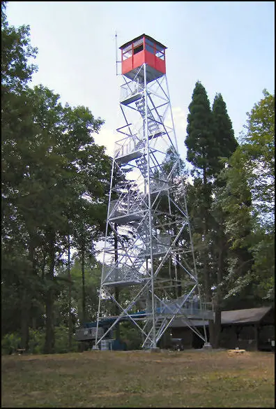
- Cab on a tower60-foot Aermotor tower with a 7 ft by 7 ft metal cabThe design: Aermotor
- Built of
- SteelGoing by its design; no source says so in words.
- Built
- 1925
- Height
- 60 ft (18.3 m)
- Elevation
- 1,107 ft (337 m)
- Agency
- Ohio Department of Natural Resources, Division of Forestry
- Land
- Unknown
- Location
- Ross County, Ohio
- Coordinates
- 39.21617, −82.97582
- Registers
- This entry
- VerifiedResearched, then checked independently. Updated 8 Oct 2026.
- Firefinder id
us-oh-scioto-trail
View from the cab
What you see from the cab: every ridge out to about 93 miles, the named peaks in sight, and other fire lookouts within view, worked out from terrain data in your browser.
Downloads about 3.5 MB of terrain data the first time.
Or see what it could see on the map: the ground in its line of sight.
History
Then and now
- 1925 Built60-foot Aermotor tower with 7x7 ft metal cab; build year given by both the NHLR entry and the plaqueSources: nhlr.org, readtheplaque.com
- 1934 StaffedOctober 1934 Chillicothe Gazette item names G. P. Schilder as towerman at the Scioto Trail ForestSource: easternuslookouts.weebly.com
- 1936 EventPortsmouth Times reports plans for a 25-foot observation tower on Two Mile Hill, open to the public; not confirmed as built or as this towerSource: easternuslookouts.weebly.com
- 1938 AlteredOhio Division of Forestry puts a fire weather station (weather vane, rain gauge, anemometer, hydro-thermograph) at the towerSource: easternuslookouts.weebly.com
- 1941 FireFire burns nearly 50 acres of Ross County land and is brought under control; account relayed through Harold Lump of the towerSource: easternuslookouts.weebly.com
- No record between 1941 and 2007
- 2007 Added to the National Historic Lookout RegisterRegistered July 20, 2007, as US 702, OH 7Source: nhlr.org
- 2010 Condition assessmentNHLR visit report, June 24, 2010: cabin in good condition and open; not staffed; directions signedSource: nhlr.org
- TodayStandingIt still stands, as far as our sources know.
Old maps of this spot
USGS topographic maps from the years a lookout stood may show it, often as a small symbol labelled “Lookout”. See the old topo maps around it on the Firefinder map, or find every scanned sheet of this spot on USGS TopoView (opens another site) (click the spot there to list them, with dates and downloads).
Story
Researched 8 Oct 2026, fact-checked.
The Scioto Trail Fire Tower stands in Ross County, Ohio, and overlooks part of the Scioto Trail State Forest.1,2 It was built in 1925 and is a 60-foot Aermotor tower topped with a 7-by-7-foot metal cab.1,2 A historical plaque says fire wardens and foresters watched for fires from the tower across Ohio.2
It belongs to a wider push in Ohio. Ohio's first fire tower went up in 1922, and Civilian Conservation Corps crews helped build fire towers from 1933 to 1935.3 The early record of this particular tower is a little tangled. A 1936 newspaper item reported plans for a 25-foot observation tower on Two Mile Hill, open to the public, and I could not tie that plan to the 60-foot tower.4 The register and the plaque both date the 60-foot tower to 1925.1,2
Most of what the record says about daily work comes from old newspaper clippings. An October 1934 item named G. P. Schilder as the towerman at the Scioto Trail Forest.4 In April 1938 the Ohio Division of Forestry put a fire weather station at the tower, with a weather vane, rain gauge, anemometer and hydro-thermograph, to collect data for forecasting serious forest fire periods.4 In April 1941 a fire that burned nearly 50 acres of Ross County land was contained, according to Harold Lump of the tower.4
The sources describe the tower as still standing. A historical plaque entry says so, and the Forest Fire Lookout Association's Ohio list marks it standing.2,5 The register entry names the Ohio Division of Forestry and the Ohio Fire Tower Restoration Project as cooperators, but describes no specific restoration work.1 It was added to the National Historic Lookout Register on July 20, 2007.1
A register visit in June 2010 found the cabin open and in good condition, with directions to the tower signed from the road, and recorded that the site was not staffed.1 An Ohio Department of Natural Resources map says a fire tower and picnic area on the forest are the sites of many reunions and family outings.6 The sources do not say whether the public may climb the tower today, so check with the state forest office before planning a special trip.
- Scioto Trail Fire Tower, National Historic Lookout Register, http://nhlr.org/lookouts/us/oh/scioto-trail-fire-tower/ (accessed 2026-10-08). ↩
- Scioto Trail Fire Tower, Read the Plaque, https://readtheplaque.com/plaque/scioto-trail-fire-tower (accessed 2026-10-08). ↩
- Brush Ridge Fire Tower Historical Marker, Historical Marker Database, https://www.hmdb.org/m.asp?m=304844 (accessed 2026-10-08). ↩
- Scioto Trail, Forest Lookouts, https://easternuslookouts.weebly.com/scioto-trail.html (accessed 2026-10-08). ↩
- Ohio Fire Lookout Towers, Forest Fire Lookout Association, https://firelookout.org/lookouts/us/oh/ (accessed 2026-10-08). ↩
- Scioto Trail State Forest map, Ohio Department of Natural Resources, https://dam.assets.ohio.gov/image/upload/odnr/forestry/Maps/sciototrail.pdf (accessed 2026-10-08). ↩
Photos
Photos keep their own rights and are shown with credit. Is one of these yours? You can ask for a different credit or for removal.
Sources
- National Historic Lookout Register (NHLR) (opens another site) Gave us: name, location, county, elevation, what it is built of, register numbers, agency, dates, photos, links National Historic Lookout Register (nhlr.org) · All rights reserved (American Resources, Inc.); facts extracted only, no prose copied. · retrieved 4 Oct 2026
- Forest Fire Lookout Association (FFLA) - US lookout lists (opens another site) Gave us: type, status, register numbers, links Forest Fire Lookout Association (firelookout.org) · No licence stated; facts extracted only, no prose copied. · retrieved 8 Oct 2026
- FOREST LOOKOUTS -- eastern US (easternuslookouts.weebly.com) (opens another site) Gave us: height, links easternuslookouts.weebly.com · No licence stated; facts only (county, coordinates where the page's own map widget gives them, status, height, design hints, register links). The site's own historical quotes, newspaper citations and narrative are not reproduced. · retrieved 8 Oct 2026
- Firefinder research Gave us: summary, design, height, status, agency, access, visiting details, dates, links, fact-check Firefinder research (sources cited in the story footnotes) · Our own research notes; each fact cites its source in the lookout's story
More about this lookout elsewhere
- NHLR register entry US 702 (nhlr.org) (opens another site)
- NHLR register entry US 702 (nhlr.org) (opens another site)
- Scioto Trail Fire Tower (Read the Plaque) (opens another site)
- Scioto Trail State Forest map (Ohio Department of Natural Resources) (opens another site)
- Brush Ridge Fire Tower Historical Marker (Historical Marker Database) (opens another site)
- FFLA Ohio lookout list (firelookout.org) (opens another site)
- Scioto Trail (easternuslookouts.weebly.com) (opens another site)
Firefinder takes facts (places, dates, numbers) from these sources and writes its own words. See all sources and licences.