Fire lookout · Cherokee County, Oklahoma
Beaver Fire Tower
Also known as Beaver Mountain
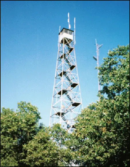
A 100-foot Aermotor lookout from 1950 on Beaver Mountain in Oklahoma's Cookson Hills, reported surplus and possibly moved to Sand Springs; its current location is unconfirmed.
- Standing
- Restricted access
- Verified
Visit & stay
Not rentable. As far as we know, this lookout cannot be booked for overnight stays.
Access
Restricted access
Access is seasonal, gated or needs a permit. Check before you go. Summit reached by roads that may be gated; access depends on gate openings, wildlife area operations and controlled hunts. Not confirmed open for climbing.
- Can you climb it?
- Unknown
- Road to the top?
- Unknown
- Trail
- Summit reached by road or road hike; access depends on gates and controlled hunts
- Staffing
- Unknown
Facts
- Status
- Type
- Cab on a tower100-foot Aermotor tower with a metal 7 by 7 foot cabThe design: Aermotor
- Built of
- SteelGoing by its design; no source says so in words.
- Built
- 1950
- Height
- 100 ft (30.5 m)
- Elevation
- 1,629 ft (497 m)
- Agency
- Oklahoma Forestry Services
- Land
- Unknown
- Location
- Cherokee County, Oklahoma
- Coordinates
- 35.66866, −94.81172
- Registers
- This entry
- VerifiedResearched, then checked independently. Updated 8 Oct 2026.
- Firefinder id
us-ok-beaver
View from the cab
What you see from the cab: every ridge out to about 93 miles, the named peaks in sight, and other fire lookouts within view, worked out from terrain data in your browser.
Downloads about 2.9 MB of terrain data the first time.
Or see what it could see on the map: the ground in its line of sight.
History
Then and now
- 1950 Built100-foot Aermotor tower with a 7x7 steel cab erected on the Cookson Hills Wildlife Management AreaSources: nhlr.org, centraluslookouts.weebly.com
- 1960 StaffedManned by ranger Jess Morton, per a 1960 Stilwell Democrat-Journal reportSource: centraluslookouts.weebly.com
- No record between 1960 and 1997
- 1997 Added to the National Historic Lookout RegisterRegistered November 7, 1997 as US 240, OK 3; nominated by Patrick McDowell, Oklahoma Forestry ServicesSource: nhlr.org
- 1997 Last staffedRemained in active service until 1997Sources: nhlr.org, summitpost.org
- TodayStandingIt still stands, as far as our sources know.
Old maps of this spot
USGS topographic maps from the years a lookout stood may show it, often as a small symbol labelled “Lookout”. See the old topo maps around it on the Firefinder map, or find every scanned sheet of this spot on USGS TopoView (opens another site) (click the spot there to list them, with dates and downloads).
Story
Researched 8 Oct 2026, fact-checked.
Beaver Fire Tower stands on Beaver Mountain, the highest point in Cherokee County, Oklahoma.1 It sits in the Cookson Hills Wildlife Management Area in the northeast of the state.2 The Aermotor tower stands 100 feet tall and carries a metal cab, 7 by 7 feet.2 It went up in 1950.2,3
A 1960 newspaper report, quoted on the Forest Lookouts site, describes a ranger named Jess Morton manning the tower, and says he could raise a warning about trespassers or any sign of fire.3 A roofed hollow stump, big enough to hold four people, serves as the visitor registration site.2
The lookout was in use until 1997.2 Patrick McDowell of the Oklahoma Forestry Services nominated it, and the National Historic Lookout Register recorded the registration on November 7, 1997.2
The tower's later history is less clear. A News On 6 report said the state forestry agency has little use for most of its fire towers and treats this one as surplus.4 The same report called the lookout abandoned, said the 100-foot structure is still sound, and floated moving it to the Keystone Ancient Forest Preserve in Sand Springs.4 A Sand Springs news item says the city has bought a disused 100-foot tower from Cookson for $108,000 and planned to bring it to the forest.5 The item does not name the tower, but its details match Beaver's, and the register lists it.5,2 I could not confirm whether the move has happened, so the tower's current location is unclear.
The summit is reached by road, but whether you can drive up depends on the current gate schedule, operations at the wildlife area and any controlled hunts.1 I found no source saying the tower is open to climbers. Do not climb it unless the state confirms it is open and safe, and check with the Oklahoma Forestry Services or the Cookson area before you go.
- Beaver Mountain, SummitPost, https://summitpost.org/beaver-mountain/969388 (accessed 2026-10-08). ↩
- Beaver Fire Tower, National Historic Lookout Register, http://nhlr.org/lookouts/us/ok/beaver-fire-tower/ (accessed 2026-10-08). ↩
- Beaver Mountain, Forest Lookouts, https://centraluslookouts.weebly.com/beaver-mountain.html (accessed 2026-10-08). ↩
- Oklahoma Forestry Service Possibly Moving Cherokee Co. Tower, News On 6, https://newson6.com/story/5e35bafafcd8ef694720caea/oklahoma-forestry-service-possibly-moving-cherokee-co-tower (accessed 2026-10-08). ↩
- Sand Springs breaks ground on new Keystone Ancient Forest Visitor Center, Sandite Pride, https://sanditepride.com/sand-springs-news/200316/keystone-ancient-forest (accessed 2026-10-08). ↩
Photos
Photos keep their own rights and are shown with credit. Is one of these yours? You can ask for a different credit or for removal.
Sources
- National Historic Lookout Register (NHLR) (opens another site) Gave us: name, location, county, elevation, type, status, register numbers, agency, dates, photos, links National Historic Lookout Register (nhlr.org) · All rights reserved (American Resources, Inc.); facts extracted only, no prose copied. · retrieved 4 Oct 2026
- FOREST LOOKOUTS -- central US (centraluslookouts.weebly.com) (opens another site) Gave us: what it is built of, design, height, links centraluslookouts.weebly.com · No licence stated; facts only (county, coordinates where the page's own map widget gives them, status, height, design hints, register links). The site's own historical quotes, newspaper citations and narrative are not reproduced. · retrieved 8 Oct 2026
- OpenStreetMap -- fire lookout structures (opens another site) Gave us: links © OpenStreetMap contributors · ODbL 1.0. (c) OpenStreetMap contributors. · retrieved 4 Oct 2026
- Firefinder research Gave us: summary, design, height, agency, access, visiting details, dates, links, fact-check Firefinder research (sources cited in the story footnotes) · Our own research notes; each fact cites its source in the lookout's story
More about this lookout elsewhere
- NHLR register entry US 240 (nhlr.org) (opens another site)
- NHLR register entry (nhlr.org) (opens another site)
- Oklahoma Forestry Service Possibly Moving Cherokee Co. Tower (News On 6) (opens another site)
- Beaver Mountain (SummitPost) (opens another site)
- Sand Springs breaks ground on new Keystone Ancient Forest Visitor Center (Sandite Pride) (opens another site)
- Beaver Mountain (centraluslookouts.weebly.com) (opens another site)
- OpenStreetMap node 357411603 (opens another site)
Firefinder takes facts (places, dates, numbers) from these sources and writes its own words. See all sources and licences.