Fire lookout · Klamath County, Oregon
Agency Hill Lookout Site
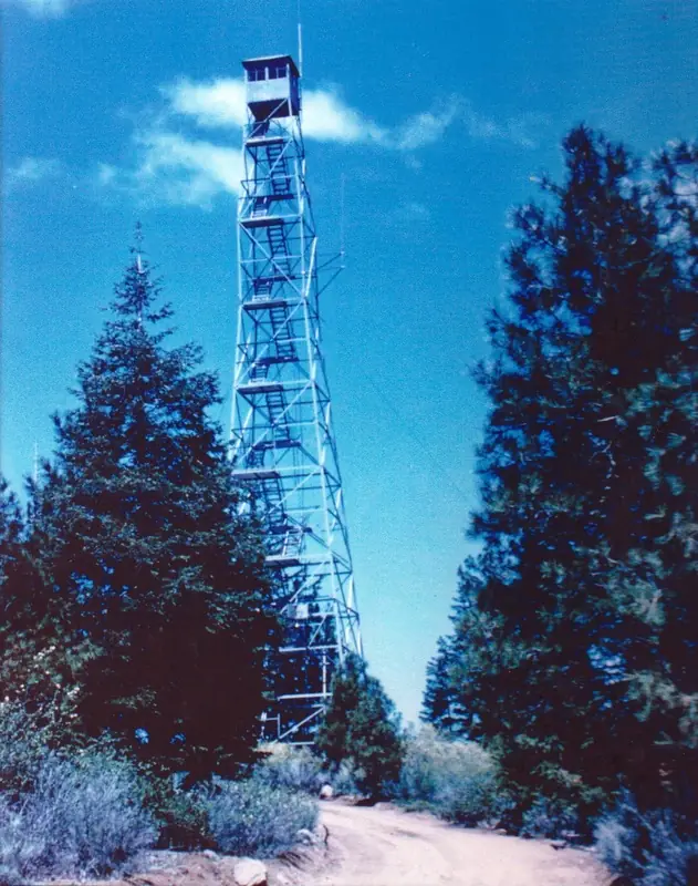
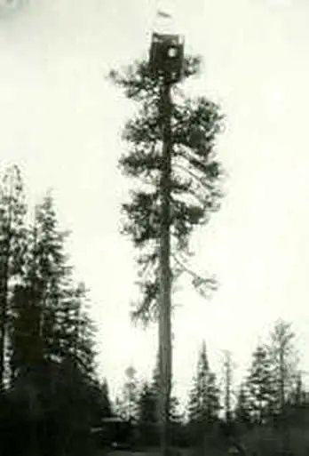
Klamath County, OR: 1930 tree cab and steel LS-40 tower, staffed into the 1950s, dismantled 1979; no dated source describes the site today; undated photo captions and a county list mention its remains.
- Gone
- Tribal land: permission required
- Verified
Tribal land: permission required
This site is on tribal land. Ask the tribe for permission before visiting, and follow its rules. On tribal land. Ask the tribe before visiting.
Gone: The lookout no longer stands. Only the site is left. Dismantled in 1979. An undated county list says the 1930 crow's nest tree has come down and is heavily decayed. Undated WillhiteWeb photo captions mention tower footings and a ground house foundation; no dated source describes current condition.
Visit & stay
Gone: site only. The lookout no longer stands, so there is nothing to climb or rent.
Access
Tribal land: permission required. See the warning at the top of this page.
- Road to the top?
- Yes, you can drive up
- Trail
- WillhiteWeb lists the hiking distance as drive-up. The register names the Klamath Indian Reservation as administrator. No source describes current access.
Facts
- Status
- Type
- Cab on a towerAermotor LS-40 steel tower with 7x7 cab (about 107 ft), built after a 1930 tree crow's nest cabThe design: Aermotor LS-40
- Built of
- Steel
- Built
- 1930
- Height
- 107 ft (32.6 m)
- Elevation
- 5,038 ft (1,536 m)
- Agency
- Klamath Indian Reservation (register); Oregon Department of Forestry from 1961 (WillhiteWeb)
- Land
- Tribal land
- Location
- Klamath County, Oregon
- Coordinates
- 42.63916, −121.93561
- Registers
- This entry
- VerifiedResearched, then checked independently. Updated 9 Oct 2026.
- Firefinder id
us-or-agency-hill
View from the cab
What the lookout saw from its cab: every ridge out to about 93 miles, the named peaks in sight, and other fire lookouts within view, worked out from terrain data in your browser.
This lookout is gone. The view is reconstructed from its recorded site and its recorded height.
Downloads about 3.5 MB of terrain data the first time.
Or see what it could see on the map: the ground in its line of sight.
History
Then and now
- 1930 Built107-foot steel Aermotor LS-40 tower erected in September and October by the Indian Service (one county list credits the Crater National Forest)Sources: oregonlookouts.weebly.com, willhiteweb.com, klamathlookouts.blogspot.com
- 1932 Replaced by a new structureRegister says a 110-foot steel tower and house replaced the tree in 1932; other sources date the steel tower to 1930Source: firetower.org
- 1941 StaffedRoy A. Yoder employed as forest ranger lookoutSource: oregonlookouts.weebly.com
- 1943 StaffedMarian Doty spent the summer as lookoutSource: oregonlookouts.weebly.com
- 1949 StaffedOne lookout was terminated after 31 days on duty; Delphine Parazoo finished the seasonSource: oregonlookouts.weebly.com
- 1953 StaffedMrs. Claude Parazoo had been lookout for the past eight years; electricity run up to the towerSources: oregonlookouts.weebly.com, willhiteweb.com
- 1961 EventResponsibility for maintenance and operation passed to the Oregon Department of ForestrySource: willhiteweb.com
- 1969 FireTwo fires reported from this stationSource: oregonlookouts.weebly.com
- 1979 RemovedLookout dismantled; gone by 1979Sources: firetower.org, firelookout.com, oregonlookouts.weebly.com
- No record between 1979 and 2011
- 2011 Added to the Former Fire Lookout Sites RegisterRegistered May 17, 2011 as US 1006, OR 364Source: firetower.org
- TodayGoneThe lookout no longer stands. Only the site is left.
Old maps of this spot
USGS topographic maps from the years a lookout stood may show it, often as a small symbol labelled “Lookout”. See the old topo maps around it on the Firefinder map, or find every scanned sheet of this spot on USGS TopoView (opens another site) (click the spot there to list them, with dates and downloads).
Story
Researched 9 Oct 2026, fact-checked.
Agency Hill sits about six miles north-northwest of Chiloquin in Klamath County.1 In 1929 the Klamath Indian Agency planned a crow's nest in a tall tree atop the hill, for use in May and June.2 A 106-foot tree cab went up in 1930.3,1
That same year a steel Aermotor LS-40 tower of about 107 feet went up.2,4 Two sources say the Indian Service built it in September and October.2,5 A county list credits the Crater National Forest with erecting it, with help from the Indian Agency.4 The register tells a different story. It says a 110-foot steel tower and house replaced the tree in 1932.3 A 1931 newspaper item and a 1953 article give 107 feet, and the county list agrees, while a 1940 survey note gives 105.2,4
Our sources name a few lookouts. In 1941 Roy A. Yoder, spelled Yader in one item, was employed as a forest ranger lookout there.2 Marian Doty spent the summer of 1943 on the lookout.2 By 1953 a newspaper said Mrs. Claude Parazoo had been the lookout for the past eight years.2 In 1949 one lookout was terminated after 31 days on duty, and Delphine Parazoo finished the season.2
WillhiteWeb says that in 1961 the Oregon Department of Forestry took over maintenance and operation, though the register names the Klamath Indian Reservation as administrator.5,3 Two fires were reported from the station in 1969.2 The lookout was dismantled in 1979.3,1,2,4 A county list says the 1930 crow's nest tree has come down and is heavily decayed.4
A WillhiteWeb photo gallery has captions reading "Tower footings" and "Ground house foundation," but the captions give no date.5 No dated source we read describes the site's condition now. WillhiteWeb lists the site's hiking distance as drive-up.5 Because the register names the Klamath Indian Reservation as administrator, ask the administrator before going.
- Agency Hill Fire Lookout Tower, firelookout.com, https://www.firelookout.com/or/agencyhill.html (accessed 2026-10-09). ↩
- Agency Hill, Forest Lookouts (Oregon), https://oregonlookouts.weebly.com/agency-hill.html (accessed 2026-10-09). ↩
- Agency Hill Lookout Site, Former Fire Lookout Sites, http://firetower.org/lookouts/us/or/agency-hill-lookout-site/ (accessed 2026-10-09). ↩
- Klamath County Fire Lookouts, https://klamathlookouts.blogspot.com/ (accessed 2026-10-09). ↩
- Agency Hill (Agency Butte) Lookout Site, WillhiteWeb, https://willhiteweb.com/oregon_lookouts/agency_hill/tower_011.htm (accessed 2026-10-09). ↩
Photos
Photos keep their own rights and are shown with credit. Is one of these yours? You can ask for a different credit or for removal.
Sources
- Former Fire Lookout Sites Register (FFLOS) (opens another site) Gave us: name, location, county, elevation, what it is built of, register numbers, agency, ownership, access, dates, photos, links Former Fire Lookout Sites Register (firetower.org) · All rights reserved (American Resources, Inc.); facts extracted only, no prose copied. · retrieved 4 Oct 2026
- Forest Fire Lookout Association (FFLA) - US lookout lists (opens another site) Gave us: type, status, register numbers, links Forest Fire Lookout Association (firelookout.org) · No licence stated; facts extracted only, no prose copied. · retrieved 8 Oct 2026
- firelookout.com -- Rex Kamstra's Forest Fire Lookout Page (opens another site) Gave us: links firelookout.com · No licence stated on the site; facts only (coordinates, elevation, built/destroyed years, design, agency). Photos mirrored with the site's stated credit. · retrieved 4 Oct 2026
- FOREST LOOKOUTS -- western US (Ron Kemnow's weebly sites) (opens another site) Gave us: design, height, links Ron Kemnow's Forest Lookouts sites (westlookouts, californialookouts, idaholookouts, montanalookouts, oregonlookouts and washingtonlookouts .weebly.com) · No licence stated; facts only (county, land manager, status word, coordinates where the page's own map widget gives them, township-range-section, height and design hints, links). The site's own newspaper quotes, citations and narrative are not reproduced. · retrieved 8 Oct 2026
- Firefinder research Gave us: summary, design, height, status, agency, staffing, visiting details, dates, links, fact-check Firefinder research (sources cited in the story footnotes) · Our own research notes; each fact cites its source in the lookout's story
More about this lookout elsewhere
- FFLOS register entry US 1006 (firetower.org) (opens another site)
- Agency Hill (Agency Butte) Lookout Site (WillhiteWeb) (opens another site)
- Klamath County Fire Lookouts (Klamath County Fire Lookouts (blog)) (opens another site)
- FFLA Oregon lookout list (firelookout.org) (opens another site)
- Agency Hill on firelookout.com (Rex Kamstra) (opens another site)
- Agency Hill on Forest Lookouts, western US (Ron Kemnow) (opens another site)
Firefinder takes facts (places, dates, numbers) from these sources and writes its own words. See all sources and licences.