Fire lookout · Douglas County, Oregon
Black Rock Lookout Site
Umpqua NF summit lookout: built 1911 or 1914-15 (sources disagree), L-4 cab 1938, burned or removed 1965; a concrete foundation is reported on the summit in 2024.
- Gone
- Access unknown
- Verified
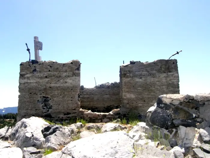
Gone: The lookout no longer stands. Only the site is left. The cab was burned or removed in 1965; the concrete foundation is reported still on the summit (2007 and 2024 accounts)
Visit & stay
Gone: site only. The lookout no longer stands, so there is nothing to climb or rent.
Access
Access unknown
We do not know the access rules. Check with the land manager before you go.
- Road to the top?
- Unknown
- Trail
- A 2024 hiker's blog describes a 2.6-mile drive up Road 950 to Whitehorse Meadows Trailhead, then a route through a 2009 burn to an old trail. This is a personal account, not an agency statement
Facts
- Status
- Type
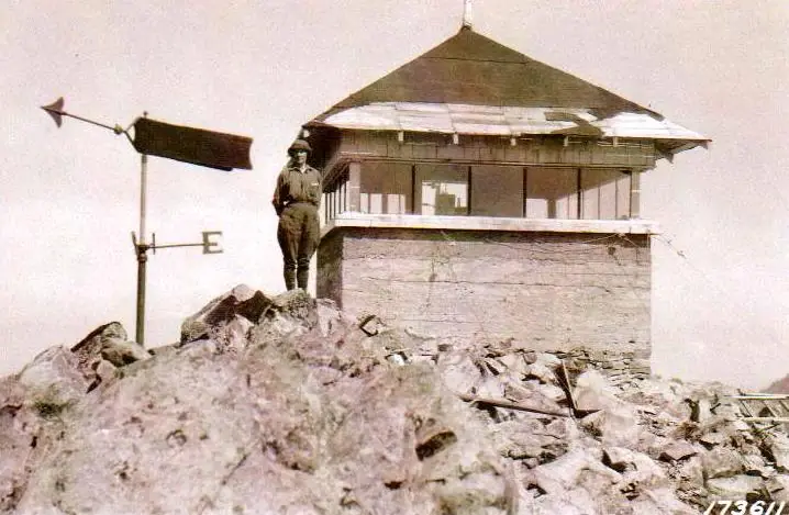
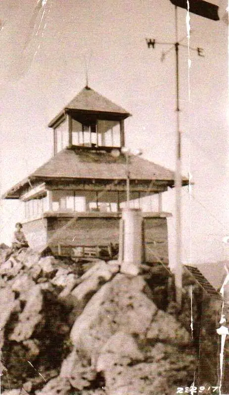
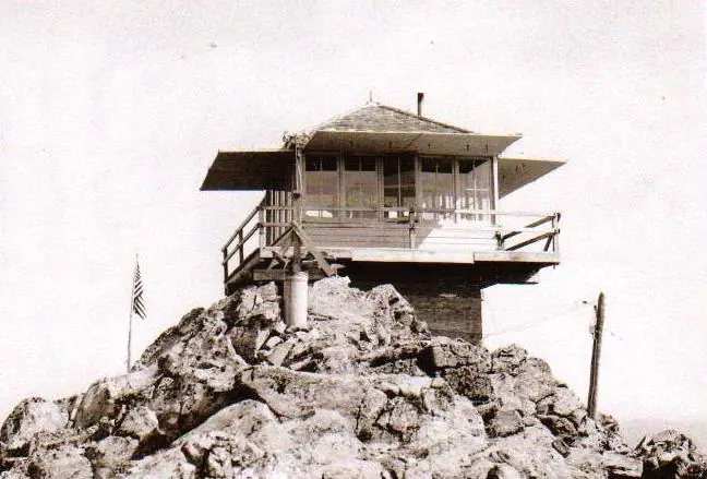
- Ground-level cabGlass-walled station on a concrete base (1914-15); cupola and new roof 1926; L-4 cab built in 1938 on the old lower wallsThe designs: L-4, Cupola house
- Built of
- WoodGoing by its design; no source says so in words.
- Built
- 1911
- Height
- Unknown
- Elevation
- 6,150 ft (1,875 m)
- Agency
- U.S. Forest Service
- Land
- Federal land
- Location
- Douglas County, Oregon
- Coordinates
- 43.16000, −122.46400 sources disagree
- Registers
- This entry
- VerifiedResearched, then checked independently. Updated 9 Oct 2026.
- Firefinder id
us-or-black-rock
View from the cab
What the lookout saw from its cab: every ridge out to about 93 miles, the named peaks in sight, and other fire lookouts within view, worked out from terrain data in your browser.
This lookout is gone. The view is reconstructed from its recorded site and a typical height for a lookout like it.
Downloads about 3.6 MB of terrain data the first time.
Or see what it could see on the map: the ground in its line of sight.
History
Then and now
- 1899 EventFirst fire lookout on the Umpqua: an observation point with a compassSource: oregonlookouts.weebly.com
- 1911 BuiltRegister says the cab was built in 1911. Forest Lookouts describes an alidade on a pole platform in use by about 1911. The 1914-15 accounts conflict; see resolved_conflictsSources: firetower.org, oregonlookouts.weebly.com
- 1915 BuiltGlass-walled house with stone and concrete walls, described as built on the summit in February 1915; being pushed to completion in September 1914Source: oregonlookouts.weebly.com
- 1917 StaffedJ. H. Bosard assigned as the forestry lookoutSource: oregonlookouts.weebly.com
- 1919 StaffedMinerva Bidwell served at the lookout for the 1919 season (reported in 1920)Source: oregonlookouts.weebly.com
- 1926 AlteredCupola and new roof added to the lookout houseSources: firetower.org, firelookout.com, oregonlookouts.weebly.com
- 1927 AlteredStandard lightning protection installedSource: oregonlookouts.weebly.com
- 1935 StaffedErnest Taylor stationed at the lookout for the summerSource: oregonlookouts.weebly.com
- 1938 Replaced by a new structureL-4 cab built atop the existing lower walls, replacing the cupola houseSources: firetower.org, firelookout.com, oregonlookouts.weebly.com
- 1941 StaffedStaffed for 80 days; reported to the Big Camas Ranger Station by forest telephone lineSource: oregonlookouts.weebly.com
- 1942 EventSeptember 1942 'Report on Lookout and Guard Stations': 65-mile road trip from Roseburg, then an 8-mile trail to the summitSource: oregonlookouts.weebly.com
- No record between 1942 and 1965
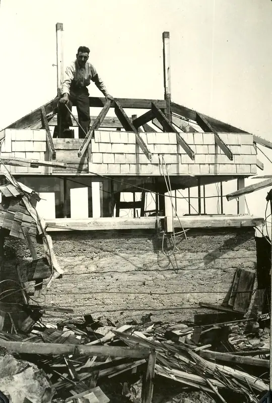
- 1965 BurnedForest Service burned the discontinued lookout building. Register says removed in 1965; firelookout.com says destroyed in 1965Sources: firetower.org, firelookout.com, oregonlookouts.weebly.com
- No record between 1965 and 2007
- 2007 EventJune 2007: foundation has survived; Forest Lookouts calls it a monument to possibly the oldest lookout site in OregonSource: oregonlookouts.weebly.com
- 2010 Added to the Former Fire Lookout Sites RegisterRegistered November 22, 2010 as US 764, OR 173Source: firetower.org
- 2024 EventHiker's blog post dated June 21, 2024 reports the old foundation still on the summit; the visit date itself is not givenSource: cherylhill.net
- TodayGoneThe lookout no longer stands. Only the site is left.
Old maps of this spot
USGS topographic maps from the years a lookout stood may show it, often as a small symbol labelled “Lookout”. See the old topo maps around it on the Firefinder map, or find every scanned sheet of this spot on USGS TopoView (opens another site) (click the spot there to list them, with dates and downloads).
Story
Researched 9 Oct 2026, fact-checked.
Black Rock is a summit in the Umpqua National Forest, in Douglas County, Oregon.1 The earliest lookout on the Umpqua, dated to 1899, was little more than a viewpoint with a compass.2 By about 1911 a sturdier arrangement stood there: an alidade mounted on a pole platform, used to pinpoint fires.2
The Register dates the first cab to 1911.1 The newspapers tell a different story. In September 1914 a paper reported that work on the glass house atop the summit was being pushed toward completion.2 A February 1915 account described a small station with walls of stone and concrete, plate glass above them, and timbers hauled up the mountain.2 The sources do not agree on when the glass house went up, so the story gives both dates.
The lookout gained a cupola and a new roof in 1926.1,2 In 1938 an L-4 cab was built on top of the old lower walls.1,3,2
Lookouts named in the newspapers include J. H. Bosard, assigned to the post in 1917; Minerva Bidwell, who served in 1919; and Ernest Taylor, stationed there in 1935.2 In 1941 the lookout was staffed for 80 days and reported over a forest telephone line to the Big Camas Ranger Station.2 A September 1942 "Report on Lookout and Guard Stations" described the trip as a 65-mile drive from Roseburg, followed by an eight-mile trail to the summit.2
The fate of the cab is also reported differently. The Register says it was removed in 1965, and firelookout.com says it was destroyed that year.1,3 The Forest Lookouts page says the Forest Service set fire to the structure once it was taken out of use.2
The concrete foundation appears to remain on the summit.2,4 A 2007 account on the Forest Lookouts page says it has weathered the elements.2 A hiker's blog post dated June 21, 2024 says the old foundation was still there.4 That hiker also wrote that the access road, Road 950, runs 2.6 miles to Whitehorse Meadows Trailhead, and that the old trail still appears on topo maps, though the Forest Service had given it up at some point.4 We found no agency statement on whether the summit is open to visitors, so check with the Umpqua National Forest before going.
- Black Rock Lookout Site, Former Fire Lookout Sites Register, http://firetower.org/lookouts/us/or/black-rock-lookout-site/ (accessed 2026-10-09). ↩
- Black Rock, Forest Lookouts (Ron Kemnow), https://oregonlookouts.weebly.com/black-rock.html (accessed 2026-10-09). ↩
- Black Rock Fire Lookout Cabin, firelookout.com, https://www.firelookout.com/or/blackrock.html (accessed 2026-10-09). ↩
- Black Rock - Just Peachy, Cheryl Hill, https://cherylhill.net/blog/2024/06/21/black-rock/ (accessed 2026-10-09). ↩
Photos
Photos keep their own rights and are shown with credit. Is one of these yours? You can ask for a different credit or for removal.
Where sources disagree
We show disagreements between sources instead of quietly picking one. If you know which is right, please tell us.
Sources disagree on the location by 14 km (9.0 mi).
- FFLA: 43.16000, −122.46400
- FFLOS: 43.19564, −122.29220
They share a register number.
The map uses the position from FFLA.
Sources
- Former Fire Lookout Sites Register (FFLOS) (opens another site) Gave us: name, county, elevation, register numbers, agency, ownership, dates, photos, links Former Fire Lookout Sites Register (firetower.org) · All rights reserved (American Resources, Inc.); facts extracted only, no prose copied. · retrieved 4 Oct 2026
- Forest Fire Lookout Association (FFLA) - US lookout lists (opens another site) Gave us: location, type, status, register numbers, links Forest Fire Lookout Association (firelookout.org) · No licence stated; facts extracted only, no prose copied. · retrieved 8 Oct 2026
- firelookout.com -- Rex Kamstra's Forest Fire Lookout Page (opens another site) Gave us: links firelookout.com · No licence stated on the site; facts only (coordinates, elevation, built/destroyed years, design, agency). Photos mirrored with the site's stated credit. · retrieved 4 Oct 2026
- FOREST LOOKOUTS -- western US (Ron Kemnow's weebly sites) (opens another site) Gave us: what it is built of, design, links Ron Kemnow's Forest Lookouts sites (westlookouts, californialookouts, idaholookouts, montanalookouts, oregonlookouts and washingtonlookouts .weebly.com) · No licence stated; facts only (county, land manager, status word, coordinates where the page's own map widget gives them, township-range-section, height and design hints, links). The site's own newspaper quotes, citations and narrative are not reproduced. · retrieved 8 Oct 2026
- Firefinder research Gave us: summary, design, status, agency, visiting details, dates, links, fact-check Firefinder research (sources cited in the story footnotes) · Our own research notes; each fact cites its source in the lookout's story
More about this lookout elsewhere
- FFLOS register entry US 764 (firetower.org) (opens another site)
- Black Rock - Just Peachy (Cheryl Hill (personal blog)) (opens another site)
- FFLA Oregon lookout list (firelookout.org) (opens another site)
- Black Rock on firelookout.com (Rex Kamstra) (opens another site)
- Black Rock on Forest Lookouts, western US (Ron Kemnow) (opens another site)
Firefinder takes facts (places, dates, numbers) from these sources and writes its own words. See all sources and licences.