Fire lookout · Deschutes County, Oregon
Cache Mountain Lookout Site
Deschutes NF lookout on Cache Mountain built 1933 as a 20-ft pole tower; destroyed or removed in 1967 (sources differ on fire and year); footings photographed later, no current description found.
- Gone
- Open to the public
- Verified
Gone: The lookout no longer stands. Only the site is left. Destroyed or removed in 1967, depending on the source; foundation blocks photographed in 2002 and footings shown in undated photos; no current description of the site found
Visit & stay
Gone: site only. The lookout no longer stands, so there is nothing to climb or rent. You may still be able to visit the site.
Access
Open to the public. On Deschutes National Forest land reached by gravel forest roads, per Will Hite's account; no closure or permit rule found in the sources read
- Road to the top?
- Unknown
- Trail
- Will Hite drove FR 2066, FR 2068 and FR 800 from the Suttle Lake road; his page lists a hiking distance of 0 to 2.5 miles and says the roads are bad at the end. No official route described.
Facts
- Status
- Type
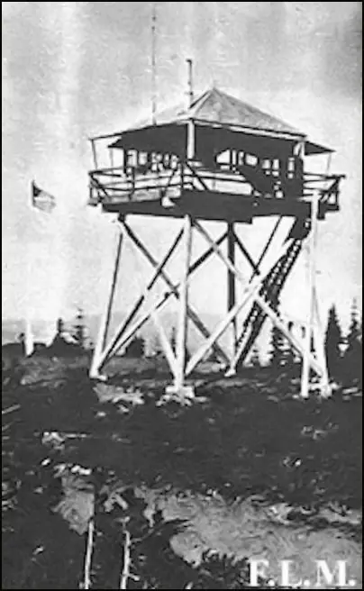
- Cab on a tower20-foot round pole tower with a 14x14 L-4 hip-roof cab, plus a 12x20 wood-frame garageThe design: L-4
- Built of
- Wood
- Built
- 1933
- Height
- 20 ft (6.1 m)
- Elevation
- 5,579 ft (1,701 m)
- Agency
- U.S. Forest Service (Deschutes National Forest)
- Land
- Federal land
- Location
- Deschutes County, Oregon
- Coordinates
- 44.38071, −121.78018
- Registers
- This entry
- VerifiedResearched, then checked independently. Updated 9 Oct 2026.
- Firefinder id
us-or-cache-mountain
View from the cab
What the lookout saw from its cab: every ridge out to about 93 miles, the named peaks in sight, and other fire lookouts within view, worked out from terrain data in your browser.
This lookout is gone. The view is reconstructed from its recorded site and its recorded height.
Downloads about 3.6 MB of terrain data the first time.
Or see what it could see on the map: the ground in its line of sight.
History
Then and now
- 1931 First staffedDeschutes NF placed two extra lookouts on duty in 1931; Wilbur Costello is named as one of them on Cache MountainSource: willhiteweb.com
- 1932 EventA road was built to the summit the following year, and a phone line was run up from the Suttle Lake junctionSource: willhiteweb.com
- 1932 StaffedLyle Anderson spotted a smoke from the station on July 16, 1932 (Bend Bulletin item quoted on Forest Lookouts page)Source: oregonlookouts.weebly.com
- 1933 Built20-foot round pole tower with L-4 cab, cost $910.84, plus a 12x20 wood-frame garageSources: firetower.org, oregonlookouts.weebly.com, willhiteweb.com
- 1937 StaffedPhillip Gould placed on Cache Mountain on July 16, 1937 (Bend Bulletin item quoted on Forest Lookouts page)Source: oregonlookouts.weebly.com
- No record between 1937 and 1957
- 1957 StaffedStation reported one fire during the 1957 seasonSource: oregonlookouts.weebly.com
- 1966 FireFormer Fire Lookout Sites register says the lookout nearly burned in the Big Lake Fire of 1966Source: firetower.org
- 1967 DestroyedEarly September 1967 fire; an Oregonian report dated September 2, 1967 (quoted by Forest Lookouts) says it destroyed the Cash Mountain lookout post; Will Hite and firelookout.com also say destroyedSources: firelookout.com, oregonlookouts.weebly.com, willhiteweb.com
- 1967 RemovedFormer Fire Lookout Sites register says it was removed in 1967Source: firetower.org
- No record between 1967 and 2002
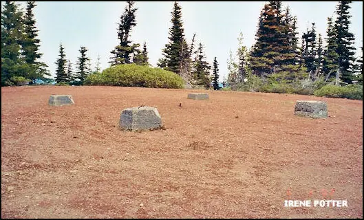
- 2002 EventRegister photo captioned Foundation blocks, dated June 3, 2002Source: firetower.org
- 2011 Added to the Former Fire Lookout Sites RegisterRegistered January 4, 2011; nominated by Irene PotterSource: firetower.org
- TodayGoneThe lookout no longer stands. Only the site is left.
Old maps of this spot
USGS topographic maps from the years a lookout stood may show it, often as a small symbol labelled “Lookout”. See the old topo maps around it on the Firefinder map, or find every scanned sheet of this spot on USGS TopoView (opens another site) (click the spot there to list them, with dates and downloads).
Story
Researched 9 Oct 2026, fact-checked.
Cache Mountain rises in the Deschutes National Forest, about 13 miles northwest of Sisters.1,2 In 1931 the forest put two extra lookouts on duty, because more than 10 million feet of wind-toppled timber posed a serious fire risk.3 A road reached the summit the next year.3 The tower went up in 1933 as a 20-foot round pole structure with an L-4 cab, built for $910.84, with a 12-by-20-foot wood-frame garage alongside.1,4,3
Lookouts staffed the cab through the 1930s and into the 1940s.4,3 Lyle Anderson spotted a smoke from the station in July 1932, and Phillip Gould was placed there in July 1937.4 The station reported one fire in 1957.4
Accounts of its end do not agree.1,2,4 The Former Fire Lookout Sites register says the tower came close to burning in the 1966 Big Lake Fire and was taken down in 1967.1 Firelookout.com says it was destroyed in 1967.2 An Oregonian report dated September 2, 1967, quoted on the Forest Lookouts page, said a fire had destroyed the "Cash Mountain lookout post."4 Will Hite's page dates the fire to early September 1967.3 The same report also mentions an Airstrip fire, but it does not say whether that was the blaze that hit the post.4 Cash is most likely a typo for Cache, since the Forest Service spells it that way.4,5 The sources agree the tower was gone by 1967, but they disagree on whether it burned or was taken down.1,2,3
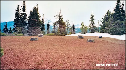
The register includes a photo captioned "Foundation blocks," dated June 3, 2002.1 Will Hite's photos show footings on the summit, though his page does not date them.3 A Forest Service page says lightning struck Cache Mountain and started a wildfire on July 23, 2002, which burned a large portion of the research natural area.5
Hite reached the site over Deschutes forest roads, leaving the Suttle Lake road on FR 2066 and FR 2068 and then taking FR 800. He calls the gravel roads fair but bad at the end, and his page lists a hiking distance of 0 to 2.5 miles.3 No source we read describes the summit's condition now, and none describes an official route or a closure, so check with the Sisters Ranger District before you go.5
- Cache Mountain Lookout Site, Former Fire Lookout Sites, http://firetower.org/lookouts/us/or/cache-mountain-lookout-site/ (accessed 2026-10-09). ↩
- Cache Mtn. Fire Lookout Tower, firelookout.com, https://www.firelookout.com/or/cachemtn.html (accessed 2026-10-09). ↩
- Cache Mountain, Oregon Fire Lookouts by Will Hite, https://willhiteweb.com/oregon_lookouts/cache_mountain_lookout/santiam_pass_344.htm (accessed 2026-10-09). ↩
- Cache Mountain, Forest Lookouts (Oregon), https://oregonlookouts.weebly.com/cache-mountain.html (accessed 2026-10-09). ↩
- Cache Mountain Research Natural Area, U.S. Forest Service Research and Development, https://research.fs.usda.gov/pnw/rnas/locations/cache-mountain (accessed 2026-10-09). ↩
Photos
Photos keep their own rights and are shown with credit. Is one of these yours? You can ask for a different credit or for removal.
Sources
- Former Fire Lookout Sites Register (FFLOS) (opens another site) Gave us: name, location, county, elevation, what it is built of, register numbers, agency, ownership, dates, photos, links Former Fire Lookout Sites Register (firetower.org) · All rights reserved (American Resources, Inc.); facts extracted only, no prose copied. · retrieved 4 Oct 2026
- Forest Fire Lookout Association (FFLA) - US lookout lists (opens another site) Gave us: type, status, register numbers, links Forest Fire Lookout Association (firelookout.org) · No licence stated; facts extracted only, no prose copied. · retrieved 8 Oct 2026
- firelookout.com -- Rex Kamstra's Forest Fire Lookout Page (opens another site) Gave us: links firelookout.com · No licence stated on the site; facts only (coordinates, elevation, built/destroyed years, design, agency). Photos mirrored with the site's stated credit. · retrieved 4 Oct 2026
- FOREST LOOKOUTS -- western US (Ron Kemnow's weebly sites) (opens another site) Gave us: design, height, links Ron Kemnow's Forest Lookouts sites (westlookouts, californialookouts, idaholookouts, montanalookouts, oregonlookouts and washingtonlookouts .weebly.com) · No licence stated; facts only (county, land manager, status word, coordinates where the page's own map widget gives them, township-range-section, height and design hints, links). The site's own newspaper quotes, citations and narrative are not reproduced. · retrieved 8 Oct 2026
- Firefinder research Gave us: summary, design, height, status, agency, access, visiting details, dates, links, fact-check Firefinder research (sources cited in the story footnotes) · Our own research notes; each fact cites its source in the lookout's story
More about this lookout elsewhere
- FFLOS register entry US 811 (firetower.org) (opens another site)
- FFLOS register entry US 811 (firetower.org) (opens another site)
- Cache Mountain (Oregon Fire Lookouts by Will Hite) (opens another site)
- Cache Mountain Research Natural Area (U.S. Forest Service Research and Development) (opens another site)
- FFLA Oregon lookout list (firelookout.org) (opens another site)
- Cache Mtn. on firelookout.com (Rex Kamstra) (opens another site)
- Cache Mountain on Forest Lookouts, western US (Ron Kemnow) (opens another site)

Firefinder takes facts (places, dates, numbers) from these sources and writes its own words. See all sources and licences.