Fire lookout · Linn County, Oregon
Chimney Peak Lookout Site
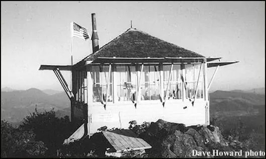
Willamette NF lookout in Linn County, Oregon: a ground L-4 cab built in 1935 and burned or removed on site in 1967.
- Gone
- Open to the public
- Verified
Gone: The lookout no longer stands. Only the site is left. Register says removed in 1967; firelookout.com says destroyed in 1967; Rex's page says disposed of by burning on site in November 1967
Visit & stay
Gone: site only. The lookout no longer stands, so there is nothing to climb or rent. You may still be able to visit the site.
Access
Open to the public. Forest Service trail page lists Chimney Peak Trail #3382 in the Middle Santiam Wilderness and describes the rocky peak, where a fire lookout once stood, as a possible goal for adventurous hikers; Forest Service Road 2041 is closed in winter
- Road to the top?
- Unknown
- Trail
- Chimney Peak Trail #3382 starts at a trailhead on the Forest Service Road 2041-646 spur and crosses the Middle Santiam River and Pyramid Creek without bridges
Facts
- Status
- Type
- Ground-level cabground L-4 cab, built 1935The design: L-4
- Built of
- WoodGoing by its design; no source says so in words.
- Built
- 1935
- Height
- Unknown
- Elevation
- 4,965 ft (1,513 m)
- Agency
- U.S. Forest Service (Willamette National Forest)
- Land
- Federal land
- Location
- Linn County, Oregon
- Coordinates
- 44.53400, −122.24813
- Registers
- This entry
- VerifiedResearched, then checked independently. Updated 9 Oct 2026.
- Firefinder id
us-or-chimney-peak
View from the cab
What the lookout saw from its cab: every ridge out to about 93 miles, the named peaks in sight, and other fire lookouts within view, worked out from terrain data in your browser.
This lookout is gone. The view is reconstructed from its recorded site and a typical height for a lookout like it.
Downloads about 3.6 MB of terrain data the first time.
Or see what it could see on the map: the ground in its line of sight.
History
Then and now
- 1914 EventA trail of 23 miles from the Cascadia ranger station to Chimney Peak and Quartzville, with a telephone line built along itSource: oregonlookouts.weebly.com
- No record between 1914 and 1931
- 1931 EventChimney Peak named as one of eleven new emergency lookout stations for the Santiam districtSource: oregonlookouts.weebly.com
- 1934 EventAugust 1934: lookout house to be erected that fall; materials to be packed by mule over 12 miles, then hauled up a 1000-foot aerial cable. September 1934: a NIRA crew was building the houseSource: oregonlookouts.weebly.com
- 1935 BuiltRegister and firelookout.com date the ground L-4 cab to 1935Sources: firetower.org, firelookout.com
- 1935 StaffedDaily Capital Journal, August 1935: a lookout stationed there, whose wife planned to spend several weeks with himSource: oregonlookouts.weebly.com
- 1936 StaffedRobert Morrow was the Forest Service lookout, per a September 1936 Bend Bulletin itemSource: oregonlookouts.weebly.com
- 1939 StaffedRobert D. Stumpf to fill the lookout fireman position, per a July 1939 Albany Democrat-Herald itemSource: oregonlookouts.weebly.com
- 1942 StaffedPhil Cane, lookout at Chimney Peak Station, per an August 1942 New Era item; lightning struck near the station but started no firesSource: oregonlookouts.weebly.com
- 1947 EventJuly 1947: Mrs. Roy Timmerman, wife of a lookout at the station, carried down the mountain on a stretcher after an appendicitis attackSource: oregonlookouts.weebly.com
- No record between 1947 and 1967
- 1967 BurnedRex's page: disposed of by burning on site, November 1967; a November 3, 1967 engineering memo quoted there names Chimney Peak with two other lookouts whose disposal requests would be submitted promptlySource: oregonlookouts.weebly.com
- 1967 RemovedRegister says the cab was removed in 1967; firelookout.com says destroyed in 1967Sources: firetower.org, firelookout.com
- No record between 1967 and 2011
- 2011 Added to the Former Fire Lookout Sites RegisterRegistered on the Former Fire Lookout Sites Register April 25, 2011Source: firetower.org
- TodayGoneThe lookout no longer stands. Only the site is left.
Old maps of this spot
USGS topographic maps from the years a lookout stood may show it, often as a small symbol labelled “Lookout”. See the old topo maps around it on the Firefinder map, or find every scanned sheet of this spot on USGS TopoView (opens another site) (click the spot there to list them, with dates and downloads).
Story
Researched 9 Oct 2026, fact-checked.
Chimney Peak sits in Linn County, Oregon, in the Willamette National Forest, at about 1,513 meters.1 Firelookout.com places it 15 miles south of Detroit.2 The register lists the U.S. Forest Service as administrator.1
Trails came first.3 A 1914 newspaper item reported 23 miles of trail reaching Chimney Peak and Quartzville from the Cascadia station, with a telephone line built as the crews went.3 In April 1931 the Statesman Journal said Chimney Peak was among eleven new emergency stations planned that year, which would give close to total visibility over the Santiam district's forests.3 In August 1934 the Eugene Register-Guard reported that a lookout house would go up that fall.3 Because the summit was quite inaccessible, builders planned to get materials up by mule over 12 miles of trail and then by a 1,000-foot aerial cable.3 The register and firelookout.com both date the ground L-4 cab to 1935.1,2
Lookouts worked the peak from 1935 into at least 1947.3 A 1935 Daily Capital Journal item said a woman planned to join her husband, a lookout at the peak, for several weeks.3 In 1936 Robert Morrow was the Forest Service lookout, and in 1939 the Albany Democrat-Herald named Robert D. Stumpf to fill the lookout fireman post. That 1939 item gave the route as 36 miles of road from Cascadia, followed by ten miles of trail.3 In August 1942 lookout Phil Cane wrote that lightning near his station knocked dishes off his table, though no fires resulted.3 In July 1947 the wife of a lookout there, Mrs. Roy Timmerman, became ill with appendicitis.3 Four men evacuated her by stretcher over steep ground and then an 11-mile trail to the South Santiam highway.3
Rex's page says the cab was burned where it stood in November 1967.3 A November 3, 1967 engineering memo, quoted on the same page, discusses burning three lookouts before their disposal requests arrived. It names Chimney Peak with two other lookouts whose disposal requests would be submitted promptly.3 The register says the cab was removed in 1967, and firelookout.com says it was destroyed that year.1,2
The Forest Service's trail page lists Chimney Peak Trail #3382 in the Middle Santiam Wilderness. It describes the rocky peak, where a fire lookout once stood, as a possible goal for adventurous hikers.4 It does not say what, if anything, remains there. The trail starts at a trailhead on a spur of Forest Service Road 2041, which is closed in winter, and it crosses the Middle Santiam River and Pyramid Creek without bridges.4 Check conditions with the Sweet Home Ranger District before you go.4
- Chimney Peak Lookout Site, Former Fire Lookout Sites Register, http://firetower.org/lookouts/us/or/chimney-peak-lookout-site/ (accessed 2026-10-09). ↩
- Chimney Peak Fire Lookout Cabin, firelookout.com, https://www.firelookout.com/or/chimneypeak.html (accessed 2026-10-09). ↩
- Chimney Peak, Forest Lookouts (Oregon), Rex's Fire Lookout Page, https://oregonlookouts.weebly.com/chimney-peak.html (accessed 2026-10-09). ↩
- Chimney Peak Trail #3382, Willamette National Forest, USDA Forest Service, https://www.fs.usda.gov/r06/willamette/recreation/trails/chimney-peak-trail-3382 (accessed 2026-10-09). ↩
Photos
Photos keep their own rights and are shown with credit. Is one of these yours? You can ask for a different credit or for removal.
Sources
- Former Fire Lookout Sites Register (FFLOS) (opens another site) Gave us: name, location, county, elevation, what it is built of, register numbers, agency, ownership, dates, photos, links Former Fire Lookout Sites Register (firetower.org) · All rights reserved (American Resources, Inc.); facts extracted only, no prose copied. · retrieved 4 Oct 2026
- Forest Fire Lookout Association (FFLA) - US lookout lists (opens another site) Gave us: type, status, register numbers, links Forest Fire Lookout Association (firelookout.org) · No licence stated; facts extracted only, no prose copied. · retrieved 8 Oct 2026
- firelookout.com -- Rex Kamstra's Forest Fire Lookout Page (opens another site) Gave us: links firelookout.com · No licence stated on the site; facts only (coordinates, elevation, built/destroyed years, design, agency). Photos mirrored with the site's stated credit. · retrieved 4 Oct 2026
- FOREST LOOKOUTS -- western US (Ron Kemnow's weebly sites) (opens another site) Gave us: links Ron Kemnow's Forest Lookouts sites (westlookouts, californialookouts, idaholookouts, montanalookouts, oregonlookouts and washingtonlookouts .weebly.com) · No licence stated; facts only (county, land manager, status word, coordinates where the page's own map widget gives them, township-range-section, height and design hints, links). The site's own newspaper quotes, citations and narrative are not reproduced. · retrieved 8 Oct 2026
- Firefinder research Gave us: summary, design, status, agency, access, visiting details, dates, links, fact-check Firefinder research (sources cited in the story footnotes) · Our own research notes; each fact cites its source in the lookout's story
More about this lookout elsewhere
- FFLOS register entry US 946 (firetower.org) (opens another site)
- Chimney Peak Trail #3382 (Willamette National Forest, USDA Forest Service) (opens another site)
- FFLA Oregon lookout list (firelookout.org) (opens another site)
- Chimney Peak on firelookout.com (Rex Kamstra) (opens another site)
- Chimney Peak on Forest Lookouts, western US (Ron Kemnow) (opens another site)
Firefinder takes facts (places, dates, numbers) from these sources and writes its own words. See all sources and licences.