Fire lookout · Lake County, Oregon
Drake Peak Lookout
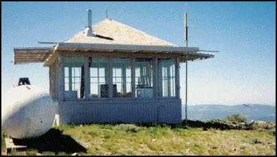
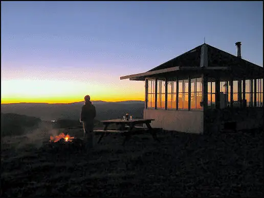
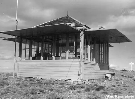
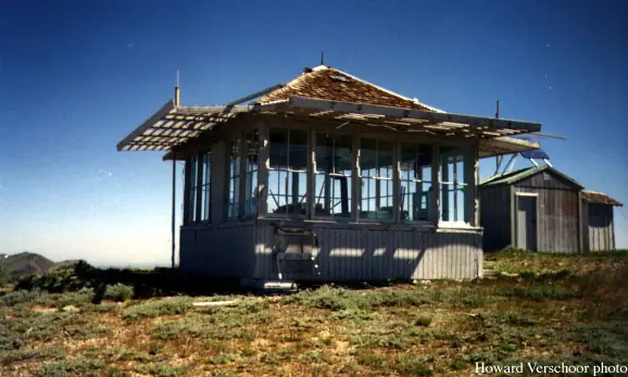
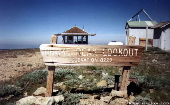
Patrol lookout since 1915, a D-6 cupola in the 1920s, then the present 1948 L-4 cab on Drake Peak, now the highest road-accessible lookout in Oregon and a Recreation.gov rental.
- Standing
- Rentable
- Open to the public
- Verified
Visit & stay
You can rent this lookout for overnight stays through recreation.gov.
- Sleeps
- Up to 4 people
Overview Located on the crest of the Warner Mountain Range at an elevation of 8,222 feet, Drake Peak Lookout hugs the wind-swept land surrounding it, offering unparalleled views into Oregon, California and Nevada. The lookout was built in 1948 and has served as a fire detection site for the surrounding area. Historically, Forest Service personnel lived long seasons in the cabin, scanning the region for lightning, flames, curls of smoke or any other indicator of possible forest fires. At one time, hundreds of these types of lookouts were in service throughout the Pacific Northwest. Today the lookout provides a unique lodging experience for guests seeking recreation and relaxation in the Fremont-Winema National Forest. Although the lookout offers some basic amenities, for guests to enjoy their experience completely, they must bring several of their own supplies. Recreation Hiking, stargazing and wildlife viewing are popular activities. The Drake-McDowell area provides solitude for backpackers and horseback riders with spectacular views of the Warner Mountains, Hart Mountain, Warner Valley and Abert Rim. A hike to the summit of Drake Peak is a popular excursion from the lookout. At night the lookout is an ideal setting for stargazing, as constellations and planets put on a dazzling display. Facilities The small, 14 x 14-foot lookout is designed to accommodate up to four people and is furnished with folding cots, a table and chairs, a wood stove for heat and limited counter space for food preparation. A picnic table is located outdoors, as is a vault toilet. There is no water on site, so guests must bring sufficient supplies for drinking, cooking and washing. Guests may fill water jugs at Mud Creek Campground approximately 6 miles away. Guests must also provide their own sleeping bags, sleeping pads, towels, dish soap, matches, cooking gear, first aid kit and firewood. Although lighting is available, it is recommended that guests bring an additional light source in case of emergencies. The Forest Service does not provide firewood for this facility. Natural Features Drake Peak Lookout sits beneath a vast sky, overlooking distant peaks, volcanic landscapes and wide-open sage basins. From its scenic perch, the lookout offers panoramic vistas and glimpses into wild places where visitors can still find solitude. Although the lookout does not sit on Drake Peak, the nearby mountain is one of several high peaks in the immediate vicinity, including Twelvemile Peak, Light Peak and Crook Peak. Composed of uplifted and eroded basalt, and sparse vegetation, views from this mountain offer unobstructed views of unique geological landforms. Diverse habitats support a variety of species. Deer, Rocky Mountain elk and pronghorn find homes in nearby forests, while several varieties of trout inhabit the lakes and streams. In the spring and fall, migrating geese, ducks and swans frame the Oregon sky. Black bears, mountain lions and bobcats, also find homes in the surrounding area.
Book on recreation.gov (opens recreation.gov)
Rental details from recreation.gov, checked 19 Oct 2026. Rules, fees and seasons change, so confirm on the booking page before you go. Data source: ridb.recreation.gov
Access
Open to the public. Rentable via Recreation.gov; combination lock code provided on booking.
- Can you climb it?
- Yes
- Road to the top?
- Yes, you can drive up
- Trail
- Road access to the summit; highest road-accessible lookout in Oregon per NHLR.
- Staffing
- Unknown
Facts
- Status
- Built of
- WoodGoing by its design; no source says so in words.
- Built
- 1928 sources disagree
- Height
- Unknown
- Elevation
- 8,352 ft (2,546 m)
- Agency
- U.S. Forest Service
- Land
- Federal land
- Location
- Lake County, Oregon
- Coordinates
- 42.30002, −120.12333 sources disagree
- Registers
- This entry
- VerifiedResearched, then checked independently. Updated 19 Oct 2026.
- Firefinder id
us-or-drake-peak
View from the cab
What you see from the cab: every ridge out to about 93 miles, the named peaks in sight, and other fire lookouts within view, worked out from terrain data in your browser.
Downloads about 3.5 MB of terrain data the first time.
Or see what it could see on the map: the ground in its line of sight.
History
Then and now
- 1915 EventFirst used as a patrol lookout; fire-finding instruments installed.Source: nhlr.org
- 1927 EventStandard Forest Service road built to the site.Source: nhlr.org
- 1928 BuiltD-6 cupola built on Drake Peak per NHLR; firelookout.com instead places a D-6 cupola cabin on nearby Light Peak in 1926 -- sources disagree on location and year.Sources: nhlr.org, firelookout.com
- No record between 1928 and 1948
- 1948 BuiltPresent L-4 ground house built new next to the cupola, cost $3,451.47.Sources: nhlr.org, firelookout.com
- No record between 1948 and 2003
- 2003 Added to the National Historic Lookout RegisterRegistered on the National Historic Lookout Register March 31, 2003.Source: nhlr.org
- TodayStandingIt still stands, as far as our sources know.
Old maps of this spot
USGS topographic maps from the years a lookout stood may show it, often as a small symbol labelled “Lookout”. See the old topo maps around it on the Firefinder map, or find every scanned sheet of this spot on USGS TopoView (opens another site) (click the spot there to list them, with dates and downloads).
Story
Researched 4 Oct 2026, fact-checked.
Fire detection on Drake Peak, in the Warner Mountains of Lake County, Oregon, goes back further than the building standing there now. The spot was first used as a patrol lookout with fire-finding instruments installed in 1915, and a small building went up there sometime after.1 Sources differ on exactly where the next structure sat: the National Historic Lookout Register says a D-6 cupola was built on the peak itself in 1928, while firelookout.com places a D-6 cupola cabin on neighboring Light Peak, a half mile northeast, in 1926.1,2 Either way, a standard Forest Service road was cut to the site in the summer of 1927, giving the lookout road access.1
In 1948 the Forest Service decided a lookout on Drake Peak itself would serve better, and built the present L-4 ground cab there, next to the older cupola, at a cost of $3,451.47.1,2 At 8,352 feet, Drake Peak is the highest fire lookout with road access in Oregon.1 For decades afterward, Forest Service staff spent entire fire seasons stationed in the small cabin, keeping a lookout for any sign of fire across the Fremont-Winema National Forest; one hazard the lookout's own description calls out is that lightning occasionally strikes the propane tank beside the cabin.1,3
The lookout still stands and now works as a Recreation.gov rental, sleeping up to four people on folding cots with a wood stove for heat.3 There's no water on site, though guests can haul water from Mud Creek Campground about six miles away.3 It's listed on the National Historic Lookout Register, registered in 2003.1
- Drake Peak Lookout, National Historic Lookout Register, http://nhlr.org/lookouts/us/or/drake-peak-lookout/ (accessed 2026-10-04). ↩
- Drake Peak Fire Lookout Cabin, Fire Lookout, https://www.firelookout.com/or/drakepeak.html (accessed 2026-10-04). ↩
- Drake Peak Lookout, Recreation.gov, https://www.recreation.gov/camping/campgrounds/234185 (accessed 2026-10-04). ↩
Photos
Photos keep their own rights and are shown with credit. Is one of these yours? You can ask for a different credit or for removal.
Where sources disagree
We show disagreements between sources instead of quietly picking one. If you know which is right, please tell us.
Sources disagree on the location by 2.8 km (1.8 mi).
- NHLR: 42.30002, −120.12333
- FFLA: 42.30051, −120.15793
- firelookout.com -- Rex Kamstra's Forest Fire Lookout Page: 42.30051, −120.15793
- recreation.gov: 42.30056, −120.15783
They share a register number.
The map uses the position from NHLR.
Sources disagree on the year it was built.
- NHLR: 1948
- firelookout.com -- Rex Kamstra's Forest Fire Lookout Page: 1926
- recreation.gov: 1948
- Every Lookout in Oregon (Cheryl Hill): 1948
Sources give different build years. Often one counts the first lookout on the site and another the structure there now.
Sources
- National Historic Lookout Register (NHLR) (opens another site) Gave us: name, location, county, elevation, register numbers, agency, dates, photos, links National Historic Lookout Register (nhlr.org) · All rights reserved (American Resources, Inc.); facts extracted only, no prose copied. · retrieved 4 Oct 2026
- Forest Fire Lookout Association (FFLA) - US lookout lists (opens another site) Gave us: type, status, register numbers, links Forest Fire Lookout Association (firelookout.org) · No licence stated; facts extracted only, no prose copied. · retrieved 8 Oct 2026
- Recreation Information Database (recreation.gov) (opens another site) Gave us: ownership, access, rental details, links Data source: ridb.recreation.gov · Public data from the US government · retrieved 19 Oct 2026
- Forest Fire Lookout Association: lookout rentals (opens another site) Gave us: rental details, links Forest Fire Lookout Association rentals list (firelookout.org) · No licence stated; facts extracted only (state, name, booking link, manager, closure note), no prose copied. The FFLA says it is not involved in managing any rental program. · retrieved 19 Oct 2026
- firelookout.com -- Rex Kamstra's Forest Fire Lookout Page (opens another site) Gave us: what it is built of, design, photos, links firelookout.com · No licence stated on the site; facts only (coordinates, elevation, built/destroyed years, design, agency). Photos mirrored with the site's stated credit. · retrieved 4 Oct 2026
- FOREST LOOKOUTS -- western US (Ron Kemnow's weebly sites) (opens another site) Gave us: links Ron Kemnow's Forest Lookouts sites (westlookouts, californialookouts, idaholookouts, montanalookouts, oregonlookouts and washingtonlookouts .weebly.com) · No licence stated; facts only (county, land manager, status word, coordinates where the page's own map widget gives them, township-range-section, height and design hints, links). The site's own newspaper quotes, citations and narrative are not reproduced. · retrieved 8 Oct 2026
- Every Lookout in Oregon (Cheryl Hill) (opens another site) Gave us: register numbers, links Every Lookout in Oregon (Cheryl Hill, cherylhill.net) · No licence stated; facts only (name, agency, elevation, year built, design and height, status word, links). Posts' narrative and photos are not reproduced. · retrieved 8 Oct 2026
- Firefinder research Gave us: summary, design, status, agency, access, visiting details, dates, links, fact-check Firefinder research (sources cited in the story footnotes) · Our own research notes; each fact cites its source in the lookout's story
More about this lookout elsewhere
- NHLR register entry US 487 (nhlr.org) (opens another site)
- NHLR register entry (nhlr.org) (opens another site)
- Recreation.gov listing (opens another site)
- Recreation.gov listing (opens another site)
- FFLA Oregon lookout list (firelookout.org) (opens another site)
- FFLA lookout rentals list (firelookout.org) (opens another site)
- Drake Peak on firelookout.com (Rex Kamstra) (opens another site)
- Drakes Peak on Forest Lookouts, western US (Ron Kemnow) (opens another site)
- Drake Peak on Every Lookout in Oregon (Cheryl Hill) (opens another site)
Firefinder takes facts (places, dates, numbers) from these sources and writes its own words. See all sources and licences.