Fire lookout · Wasco County, Oregon
Flag Point Lookout
Mt. Hood NF lookout: 1924 first cabin, present 41-ft R-6 tower from 1973, staffed in summers, destroyed by the Grasshopper Fire, reported August 1, 2026.
- Gone
- Restricted access
- Verified
Gone: The lookout no longer stands. Only the site is left.
Visit & stay
recreation.gov still lists this lookout for overnight stays.
- Fee
- The lookout is available during winter months, from Nov. 1 to May 31. The maximum length stay is seven consecutive nights. Fees are used for the maintenance and preservation of the lookout.
- Getting there
- During summer driving conditions the lookout can be accessed by driving, 4WD or AWD is highly recommended.
Overview Flag Point Lookout is situated on the eastern side of Mt. Hood and is surrounded by the Badger Creek Wilderness, the lookout boasts a spectacular panorama view of snow-covered treetops and rugged Cascade peaks. It provides access to a variety of recreational opportunities, including fishing, hiking and wildlife viewing, as well as winter sports. During summer driving conditions the lookout can be accessed by driving, 4WD or AWD is highly recommended. During winter driving conditions, the lookout can only be accessed by skiing, snowmobiling or snowshoeing either 10 or 17 miles from a parking area at Billybob Sno-park or Little John Sno-park. Winter driving conditions can occur in early fall and persist late into the spring. A Northwest Forest Pass is required for the parking area at Billy Bob Sno-park, annual or day passes can be purchased in person at the Hood River Ranger Station or online at https://www.discovernw.org/annual-northwest-forest-pass. An ODOT Sno-park pass is required for parking at Little John Sno-park and can be purchased at local vendors or online at https://www.oregon.gov/ODOT/DMV/pages/vehicle/sno_park_permits.aspx. Guests are responsible for their own travel arrangements and safety, and must bring several of their own amenities. Basic overnight amenities such as a wood heating stove, gas cook stove, full size bed, cooking utensils, firewood, and a pit toilet are provided. Recreation In the summer months, visitors enjoy hiking, horseback riding and mountain biking in the area, as well as the gorgeous views from the lookout. The lookout is near Fifteenmile Campground, and an established network of trails within the Badger Creek wilderness. The area is popular among winter sports enthusiasts as well, as the location provides access to numerous cross country skiing, snowshoeing and snowmobiling trails. It is a shared winter recreation area and lookout guests should expect other winter sports enthusiasts in the area. Facilities The cabin is atop a 40-foot tower and is surrounded by a wooden catwalk. The 14-by-14 room is furnished with a small bed, a wood stove for heating and a table and chairs. It has a propane cook stove and solar-powered lights. There is no water on-site. An outhouse with a vault toilet is located on the ground, as well as a shed stocked with firewood. A rope and pulley system is available to transport gear, as well as firewood, up and down the tower with ease. Guests will need to bring their own water for drinking, cooking and cleaning purposes, as well as their own sleeping bags/bedding, a flashlight or lantern for emergencies, first aid kit, washcloths and towels, dish soap and garbage bags. This is a "Pack it in, Pack it out" facility; guests will need to carry out all trash and clean the facility prior to leaving. Natural Features The tower sits in the center of the Badger Creek Wilderness, at 5,500ft of elevation, on the south east side of Mt. Hood. Of the nine peaks in Oregon's Cascade Mountain Range, Mt. Hood stands the tallest, at 11,239 feet. It is thickly forested and capped with glaciers and snow. The lookout tower is one of three Forest Service watchtowers on Mt. Hood and it is still used to spot fires during summertime each year. A variety of wildlife make its home in the area. Contact Info This location is unstaffed. To speak with our main office for general information, please call: (541) 352-6002.
Check before booking
FFLA reports this lookout burned in 2026, but recreation.gov still lists it. Check with the forest before booking.
See the listing on recreation.gov (opens recreation.gov)
Rental details from recreation.gov, checked 19 Oct 2026. Rules, fees and seasons change, so confirm on the booking page before you go. Data source: ridb.recreation.gov
Access
Restricted access
Access is seasonal, gated or needs a permit. Check before you go. Fire closures apply. The Forest asks visitors to observe all closures and fire restrictions. The sources do not say whether the summit is inside a closure.
- Road to the top?
- Unknown
- Trail
- The lookout burned in 2026, so there is no structure to visit. Before the fire, summer access was by road (4WD or AWD recommended on the recreation.gov listing) and winter access was on skis, snowmobile or snowshoes.
Facts
- Status
- sources disagree
- Type
- Cab on a towerR-6 flat cab on a 41-foot timber tower (1973); earlier 30-foot L-4 pole tower (1932) and 40-foot pole tower with 6 by 6 foot cab (1924)The designs: L-4, R-6
- Built of
- Wood
- Built
- 1924
- Height
- 41 ft (12.5 m)
- Elevation
- 5,636 ft (1,718 m)
- Agency
- U.S. Forest Service, Mt. Hood National Forest (Barlow Ranger District)
- Land
- Federal land
- Location
- Wasco County, Oregon
- Coordinates
- 45.31708, −121.46888
- Registers
- This entry
- VerifiedResearched, then checked independently. Updated 19 Oct 2026.
- Firefinder id
us-or-flag-point
View from the cab
What the lookout saw from its cab: every ridge out to about 93 miles, the named peaks in sight, and other fire lookouts within view, worked out from terrain data in your browser.
This lookout is gone. The view is reconstructed from its recorded site and its recorded height.
Downloads about 3.7 MB of terrain data the first time.
Or see what it could see on the map: the ground in its line of sight.
History
Then and now
- 1924 BuiltFirst lookout: a 6 by 6 foot cab on a 40-foot pole towerSources: nhlr.org, firelookout.com
- 1932 Replaced by a new structureReplaced with an L-4 cab on a 30-foot pole towerSource: nhlr.org
- No record between 1932 and 1973
- 1973 BuiltPresent R-6 flat-top cab on a 41-foot timber towerSources: nhlr.org, cherylhill.net, firelookout.com
- No record between 1973 and 2003
- 2003 Added to the National Historic Lookout RegisterRegistered March 31, 2003 per NHLRSource: nhlr.org
- 2004 RestoredRepainted and steps repaired by the chapter.Source: firelookout.org
- No record between 2004 and 2026
- 2026 BurnedDestroyed by the Grasshopper Fire. The Forest said 'last night' in its August 1 release; another report says the early morning hours of Saturday, August 1Sources: fs.usda.gov, cherylhill.net, youroregonnews.com
- 2026 FireLightning-caused Grasshopper Fire spotted east of Grasshopper Point on July 23Source: cherylhill.net
- TodayGoneThe lookout no longer stands. Only the site is left.
Old maps of this spot
USGS topographic maps from the years a lookout stood may show it, often as a small symbol labelled “Lookout”. See the old topo maps around it on the Firefinder map, or find every scanned sheet of this spot on USGS TopoView (opens another site) (click the spot there to list them, with dates and downloads).
Story
Researched 9 Oct 2026, fact-checked.
Flag Point sits on the east side of Mount Hood, in Wasco County, Oregon, within the Mt. Hood National Forest.1 A lookout first went up on the summit in 1924, a 6-by-6-foot cabin on a 40-foot pole tower.1,2 In 1932 the first structure was replaced with an L-4 cab on a 30-foot pole.1 The present tower, with an R-6 flat cab, was built in 1973.1,3,2 Sources disagree on its height. Most say 41 feet, but the recreation.gov listing and one 2026 news report say 40.1,3,4,5,2
The forest staffed the lookout every summer as part of its fire-watch network, and it was available to rent in the off-season.6,2
Lightning started the Grasshopper Fire, which was first seen east of Grasshopper Point on July 23.3 Crews spent three days clearing vegetation around the structure, cutting trees where they could, and applying fire retardant to it.6 The Forest Service said the lookout was destroyed overnight, and another report puts the loss in the early hours of August 1.6,4 The summer staffer was safely evacuated.3
The lookout is gone.6,2 The sources we read do not describe what, if anything, remains on the summit.6,3,4 A recreation.gov listing still describes the lookout, even though the fire destroyed it.6,5 The forest reminds visitors to respect all closures and fire restrictions, so check its current notices before any trip there.6
- Flag Point Lookout, National Historic Lookout Register, http://nhlr.org/lookouts/us/or/flag-point-lookout/ (accessed 2026-10-09). ↩
- Flag Point Fire Lookout Tower, firelookout.com (Forest Fire Lookout Association), https://www.firelookout.com/or/flagpoint.html (accessed 2026-10-09). ↩
- Flag Point Lookout Has Burned in the Grasshopper Fire, Every Lookout in Oregon, https://cherylhill.net/firelookouts/2026/08/01/flag-point-lookout-has-burned-in-the-grasshopper-fire/ (accessed 2026-10-09). ↩
- Remembering Flag Point Lookout after Grasshopper Fire destruction, Your Oregon News, https://youroregonnews.com/2026/08/05/historic-flag-point-lookout-destroyed-by-grasshopper-fire/ (accessed 2026-10-09). ↩
- Flag Point Lookout, Recreation.gov, https://www.recreation.gov/camping/campgrounds/10289153 (accessed 2026-10-09). ↩
- Grasshopper Fire consumes Flag Point Lookout, Mt. Hood National Forest, U.S. Forest Service, https://www.fs.usda.gov/r06/mthood/newsroom/releases/grasshopper-fire-consumes-flag-point-lookout (accessed 2026-10-09). ↩
Photos
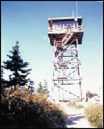
Photos keep their own rights and are shown with credit. Is one of these yours? You can ask for a different credit or for removal.
Where sources disagree
We show disagreements between sources instead of quietly picking one. If you know which is right, please tell us.
Sources disagree on whether it still stands.
- FFLA: Gone
- NHLR: Standing
- recreation.gov: Standing
- firelookout.com -- Rex Kamstra's Forest Fire Lookout Page: Gone
- Every Lookout in Oregon (Cheryl Hill): Gone
NHLR lists lookouts that were standing when registered. firelookout.com lists it, but not on its map of standing lookouts.
Sources
- National Historic Lookout Register (NHLR) (opens another site) Gave us: name, location, county, elevation, what it is built of, register numbers, agency, dates, photos, links National Historic Lookout Register (nhlr.org) · All rights reserved (American Resources, Inc.); facts extracted only, no prose copied. · retrieved 4 Oct 2026
- Forest Fire Lookout Association (FFLA) - US lookout lists (opens another site) Gave us: type, status, register numbers, dates, links Forest Fire Lookout Association (firelookout.org) · No licence stated; facts extracted only, no prose copied. · retrieved 8 Oct 2026
- Recreation Information Database (recreation.gov) (opens another site) Gave us: ownership, access, rental details, links Data source: ridb.recreation.gov · Public data from the US government · retrieved 19 Oct 2026
- firelookout.com -- Rex Kamstra's Forest Fire Lookout Page (opens another site) Gave us: links firelookout.com · No licence stated on the site; facts only (coordinates, elevation, built/destroyed years, design, agency). Photos mirrored with the site's stated credit. · retrieved 4 Oct 2026
- Forest Fire Lookout Association chapter reports (opens another site) Gave us: dates, links Forest Fire Lookout Association, chapter and restoration-grant reports (firelookout.org) · No licence stated; facts only (dates, names, the kind of work done). Every note is our own wording and every event links to the FFLA report it comes from. Positions are copied from the NHLR, FFLOS and FFLA records. · retrieved 8 Oct 2026
- FOREST LOOKOUTS -- western US (Ron Kemnow's weebly sites) (opens another site) Gave us: design, height, links Ron Kemnow's Forest Lookouts sites (westlookouts, californialookouts, idaholookouts, montanalookouts, oregonlookouts and washingtonlookouts .weebly.com) · No licence stated; facts only (county, land manager, status word, coordinates where the page's own map widget gives them, township-range-section, height and design hints, links). The site's own newspaper quotes, citations and narrative are not reproduced. · retrieved 8 Oct 2026
- Every Lookout in Oregon (Cheryl Hill) (opens another site) Gave us: links Every Lookout in Oregon (Cheryl Hill, cherylhill.net) · No licence stated; facts only (name, agency, elevation, year built, design and height, status word, links). Posts' narrative and photos are not reproduced. · retrieved 8 Oct 2026
- Firefinder research Gave us: summary, design, height, agency, access, visiting details, dates, links, fact-check Firefinder research (sources cited in the story footnotes) · Our own research notes; each fact cites its source in the lookout's story
More about this lookout elsewhere
- NHLR register entry US 489 (nhlr.org) (opens another site)
- NHLR register entry (nhlr.org) (opens another site)
- Recreation.gov listing (opens another site)
- Grasshopper Fire consumes Flag Point Lookout (Mt. Hood National Forest, U.S. Forest Service) (opens another site)
- Remembering Flag Point Lookout after Grasshopper Fire destruction (Your Oregon News) (opens another site)
- FFLA Oregon lookout list (firelookout.org) (opens another site)
- Forest Fire Lookout Association chapter reports: work on Flag Point Lookout (opens another site)
- Flag Point on firelookout.com (Rex Kamstra) (opens another site)
- Flag Point on Forest Lookouts, western US (Ron Kemnow) (opens another site)
- Flag Point on Every Lookout in Oregon (Cheryl Hill) (opens another site)
Firefinder takes facts (places, dates, numbers) from these sources and writes its own words. See all sources and licences.