Fire lookout · Lane County, Oregon
Horse Pasture Lookout Site
Also known as Horsepasture Mountain
A D-6 cupola cabin on Horsepasture Mountain in Lane County, built in 1922 after a 1915 camp, was removed in 1965; a flat spot with metal stakes marks the summit.
- Gone
- Open to the public
- Verified
Gone: The lookout no longer stands. Only the site is left. Cabin removed in 1965; a flat spot with metal stakes marks the summit where it stood.
Visit & stay
Gone: site only. The lookout no longer stands, so there is nothing to climb or rent. You may still be able to visit the site.
Access
Open to the public. Out-and-back hike from a trailhead reached by driving Highway 126 east from Eugene to McKenzie Bridge.
- Road to the top?
- Unknown
- Trail
- 3.0 miles round trip with about 945 feet of elevation gain, from the Horsepasture Mountain trailhead
Facts
- Status
- Type
- Ground-level cabD-6 cupola cabinThe design: D-6
- Built of
- WoodGoing by its design; no source says so in words.
- Built
- 1922
- Height
- Unknown
- Elevation
- 5,660 ft (1,725 m)
- Agency
- U.S.Forest Service
- Land
- Federal land
- Location
- Lane County, Oregon
- Coordinates
- 44.11583, −122.08796
- Registers
- This entry
- VerifiedResearched, then checked independently. Updated 9 Oct 2026.
- Firefinder id
us-or-horse-pasture
View from the cab
What the lookout saw from its cab: every ridge out to about 93 miles, the named peaks in sight, and other fire lookouts within view, worked out from terrain data in your browser.
This lookout is gone. The view is reconstructed from its recorded site and a typical height for a lookout like it.
Downloads about 4.2 MB of terrain data the first time.
Or see what it could see on the map: the ground in its line of sight.
History
Then and now
- 1915 First staffedForest guard stationed at the site, which began as a campSources: firetower.org, oregonlookouts.weebly.com
- 1918 FireA lookout reading helped locate a fire for firefighters on trail workSource: oregonlookouts.weebly.com
- 1920 EventPlan announced for a 12-by-12 house with a glass cupolaSource: oregonlookouts.weebly.com
- 1921 StaffedDorothy Dickey, a University of Oregon student, lookoutSource: oregonlookouts.weebly.com
- 1922 BuiltD-6 cupola cabin constructed per the register; January 1923 item says one standard lookout house built during the 1922 seasonSources: firetower.org, oregonlookouts.weebly.com
- 1927 EventPhoto caption dates a Horsepasture lookout house to 1927; conflicts with the 1922 dateSource: npshistory.com
- No record between 1927 and 1950
- 1950 EventRadio placed on Horsepasture Mountain by the Forest Service for spray-plane direction in a spruce budworm projectSource: oregonlookouts.weebly.com
- No record between 1950 and 1965
- 1965 RemovedRegister and Weebly history say removed; firelookout.com says destroyedSources: firetower.org, firelookout.com, oregonlookouts.weebly.com
- No record between 1965 and 2011
- 2011 Added to the Former Fire Lookout Sites RegisterRegistered on the Former Fire Lookout Sites Register, May 8, 2011Source: firetower.org
- TodayGoneThe lookout no longer stands. Only the site is left.
Old maps of this spot
USGS topographic maps from the years a lookout stood may show it, often as a small symbol labelled “Lookout”. See the old topo maps around it on the Firefinder map, or find every scanned sheet of this spot on USGS TopoView (opens another site) (click the spot there to list them, with dates and downloads).
Story
Researched 9 Oct 2026, fact-checked.
Horsepasture Mountain, also written Horse Pasture, has a summit at 5,660 feet in the Willamette National Forest, roughly eight miles from McKenzie Bridge to the south, in Lane County.1,2
The register says the site began in 1915 as a camp, and an August 1915 newspaper item reported that Ralph Allen was stationed there.1,2 In 1920 a newspaper said a house would be built, and that the general plan for such buildings called for a glass cupola on top.2 The register dates the cabin to 1922, and a January 1923 item reports that a standard lookout house went up on the peak during the 1922 season.1,2
Women staffed the post in the late 1910s and early 1920s.2 A University of Oregon student, Dorothy Dickey, was lookout in 1921, and a 1922 item said she would return to the post that summer.2 In July 1918 a reading from this lookout, combined with a second station's line of sight, helped firefighters pin down a fire's exact location.2
In June 1950 the Forest Service placed a radio on the mountain to help direct spray planes in a spruce budworm project.2
The register says the cabin was taken down in 1965, and the Weebly history agrees.1,2 firelookout.com says it was destroyed that year.3 A photo caption in a Willamette National Forest history collection dates a Horsepasture lookout house to 1927, which does not match the 1922 date given elsewhere.4
Today a short out-and-back hike of 3.0 miles round trip, with about 945 feet of climbing, reaches the summit from a trailhead that is reached by driving Highway 126 east from Eugene, then taking forest roads.5 The Oregon Hikers guide says a level patch beside the summit, marked by metal stakes, is where the old lookout stood.5 No source describes what else remains at the site now.
- Horse Pasture Lookout Site, Former Fire Lookout Sites Register, http://firetower.org/lookouts/us/or/horse-pasture-lookout-site/ (accessed 2026-10-09). ↩
- Horsepasture Mountain, Forest Lookouts (western US), Ron Kemnow, https://oregonlookouts.weebly.com/horsepasture-mountain.html (accessed 2026-10-09). ↩
- Horse Pasture Fire Lookout Cabin, firelookout.com, https://www.firelookout.com/or/horsepasture.html (accessed 2026-10-09). ↩
- Willamette National Forest History, photo captions, National Park Service history of the Willamette National Forest, https://npshistory.com/publications/usfs/region/6/willamette/history/photos-6.htm (accessed 2026-10-09). ↩
- Horsepasture Mountain Hike, Oregon Hikers Field Guide, https://www.oregonhikers.org/field_guide/Horsepasture_Mountain_Hike (accessed 2026-10-09). ↩
Photos
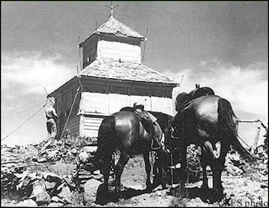
Photos keep their own rights and are shown with credit. Is one of these yours? You can ask for a different credit or for removal.
Sources
- Former Fire Lookout Sites Register (FFLOS) (opens another site) Gave us: name, location, county, elevation, what it is built of, register numbers, agency, ownership, dates, photos, links Former Fire Lookout Sites Register (firetower.org) · All rights reserved (American Resources, Inc.); facts extracted only, no prose copied. · retrieved 4 Oct 2026
- Forest Fire Lookout Association (FFLA) - US lookout lists (opens another site) Gave us: type, status, register numbers, links Forest Fire Lookout Association (firelookout.org) · No licence stated; facts extracted only, no prose copied. · retrieved 8 Oct 2026
- firelookout.com -- Rex Kamstra's Forest Fire Lookout Page (opens another site) Gave us: links firelookout.com · No licence stated on the site; facts only (coordinates, elevation, built/destroyed years, design, agency). Photos mirrored with the site's stated credit. · retrieved 4 Oct 2026
- FOREST LOOKOUTS -- western US (Ron Kemnow's weebly sites) (opens another site) Gave us: links Ron Kemnow's Forest Lookouts sites (westlookouts, californialookouts, idaholookouts, montanalookouts, oregonlookouts and washingtonlookouts .weebly.com) · No licence stated; facts only (county, land manager, status word, coordinates where the page's own map widget gives them, township-range-section, height and design hints, links). The site's own newspaper quotes, citations and narrative are not reproduced. · retrieved 8 Oct 2026
- Firefinder research Gave us: summary, design, status, agency, access, visiting details, dates, links, fact-check Firefinder research (sources cited in the story footnotes) · Our own research notes; each fact cites its source in the lookout's story
More about this lookout elsewhere
- FFLOS register entry US 966 (firetower.org) (opens another site)
- History of The Willamette National Forest, photos (npshistory.com) (opens another site)
- Horsepasture Mountain Hike (Oregon Hikers Field Guide) (opens another site)
- FFLA Oregon lookout list (firelookout.org) (opens another site)
- Horse Pasture on firelookout.com (Rex Kamstra) (opens another site)
- Horsepasture Mountain on Forest Lookouts, western US (Ron Kemnow) (opens another site)
Firefinder takes facts (places, dates, numbers) from these sources and writes its own words. See all sources and licences.