Fire lookout · Klamath County, Oregon
Lookout Butte Lookout Site (Klamath County)
Also known as Lookout Butte
Klamath County lookout tower on Lookout Butte near Crater Lake, dated 1942 (1932 in some sources), removed or destroyed in 1972; no source describes the site today.
- Gone
- Access unknown
- Verified
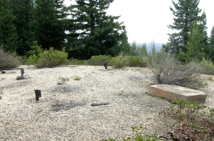
Gone: The lookout no longer stands. Only the site is left. Removed or destroyed in 1972; no source describes what remains at the site
Visit & stay
Gone: site only. The lookout no longer stands, so there is nothing to climb or rent.
Access
Access unknown
We do not know the access rules. Check with the land manager before you go.
- Road to the top?
- Unknown
Facts
- Status
- Type
- Cab on a tower40' wooden L-4 tower with a 14x14 cabThe design: L-4
- Built of
- Wood
- Built
- 1942
- Height
- 40 ft (12.2 m)
- Elevation
- 6,118 ft (1,865 m)
- Agency
- U.S. Forest Service, Rogue River and Winema National Forests
- Land
- Federal land
- Location
- Klamath County, Oregon
- Coordinates
- 42.98371, −121.94039
- Registers
- This entry
- VerifiedResearched, then checked independently. Updated 9 Oct 2026.
- Firefinder id
us-or-lookout-butte-klamath-county
View from the cab
What the lookout saw from its cab: every ridge out to about 93 miles, the named peaks in sight, and other fire lookouts within view, worked out from terrain data in your browser.
This lookout is gone. The view is reconstructed from its recorded site and its recorded height.
Downloads about 3.8 MB of terrain data the first time.
Or see what it could see on the map: the ground in its line of sight.
History
Then and now
- 1942 BuiltBuild year per the Klamath lookouts blog and a March 1942 Forest Service memo on buying materials; the register and firelookout.com say 1932Sources: oregonlookouts.weebly.com, klamathlookouts.blogspot.com
- 1948 First staffedGlenn Davis stationed on Lookout Butte as the Rogue River forest placed lookouts at posts (first staffing in our sources)Source: oregonlookouts.weebly.com
- 1949 FireFire apparently started by a cigarette burned about half an acre of lodgepole pine; Antley and a Lake of the Woods crew fought it (July 11, 1949 item)Source: oregonlookouts.weebly.com
- 1949 StaffedMr. and Mrs. Ray Antley to operate the tower (Herald and News, June 30, 1949)Source: oregonlookouts.weebly.com
- 1952 EventNewspaper item: porkies consumed most of the tires off two cars parked on the butte over two summersSource: oregonlookouts.weebly.com
- 1953 EventCoast and Geodetic Survey station description: four-legged wooden tower about 60 feet highSource: oregonlookouts.weebly.com
- 1958 StaffedBen Hunnemuller spent a month as fire lookout and weather station reporterSource: oregonlookouts.weebly.com
- 1972 RemovedRegister says removed; firelookout.com says destroyedSources: firetower.org, firelookout.com
- No record between 1972 and 2011
- 2011 Added to the Former Fire Lookout Sites RegisterRegistered June 4, 2011 as US 1028, OR 386Source: firetower.org
- TodayGoneThe lookout no longer stands. Only the site is left.
Old maps of this spot
USGS topographic maps from the years a lookout stood may show it, often as a small symbol labelled “Lookout”. See the old topo maps around it on the Firefinder map, or find every scanned sheet of this spot on USGS TopoView (opens another site) (click the spot there to list them, with dates and downloads).
Story
Researched 9 Oct 2026, fact-checked.
Lookout Butte stood in Klamath County, about five miles northeast of Mount Scott.1,2 The Rogue River and Winema National Forests managed the lookout.3
In March 1942 the Rogue River National Forest supervisor sent a memo to the regional forester about buying materials for the Lookout Butte project.2 The memo asked for a standard creosoted 40-foot tower, plan CT-3, and said a 14-by-14 house was already in stock.2 The Klamath County lookouts blog gives 1942 as the construction year and describes a 40-foot timber tower with a 14-by-14 cab.3 The Former Fire Lookout Sites register and firelookout.com both give 1932 instead, so the sources disagree on the build year.1,4
In 1948 the Forest Service was assigning lookouts to posts across the Rogue River forest, and Glenn Davis was posted at Lookout Butte.2 In June 1949 the Herald and News reported that Mr. and Mrs. Ray Antley would run the tower, which could see reservation land and had communication with the Indian agency.2
In July 1949 a fire apparently started by a cigarette burned about half an acre of lodgepole pine before it was brought under control.2 Ray Antley, Rex Morehouse and two men from a Lake of the Woods crew fought it.2
In 1952 a newspaper item reported that "porkies" had consumed most of the tires off two cars parked on the butte over two summers.2 In 1958 Ben Hunnemuller, a Forest Service employee from Fort Klamath, spent a month staffing the lookout and reporting weather there.2
The sources disagree on how the tower ended. The register says it was removed in 1972, while firelookout.com says it was destroyed that year.1,4 A 1953 Coast and Geodetic Survey station description, the last physical description we found, calls it a four-legged wooden tower about 60 feet high.2 That height does not match the 40 feet that the register and firelookout.com give.1,4
No source we read describes what, if anything, remains of the tower or its site today, or whether the public can reach the butte. Anyone planning a trip should ask the forest office before going.
- Lookout Butte Lookout Site (Klamath County), Former Fire Lookout Sites, http://firetower.org/lookouts/us/or/lookout-butte-lookout-site-klamath-county/ (accessed 2026-10-09). ↩
- Lookout Butte - Forest Lookouts, Forest Lookouts (Oregon), https://oregonlookouts.weebly.com/lookout-butte1.html (accessed 2026-10-09). ↩
- Klamath County Fire Lookouts, Klamath County Fire Lookouts blog, https://klamathlookouts.blogspot.com/ (accessed 2026-10-09). ↩
- Lookout Butte Fire Lookout Tower, firelookout.com, https://www.firelookout.com/or/lookoutbutte88.html (accessed 2026-10-09). ↩
Photos
Photos keep their own rights and are shown with credit. Is one of these yours? You can ask for a different credit or for removal.
Sources
- Former Fire Lookout Sites Register (FFLOS) (opens another site) Gave us: name, location, county, elevation, what it is built of, register numbers, agency, ownership, dates, photos, links Former Fire Lookout Sites Register (firetower.org) · All rights reserved (American Resources, Inc.); facts extracted only, no prose copied. · retrieved 4 Oct 2026
- Forest Fire Lookout Association (FFLA) - US lookout lists (opens another site) Gave us: type, status, register numbers, links Forest Fire Lookout Association (firelookout.org) · No licence stated; facts extracted only, no prose copied. · retrieved 8 Oct 2026
- firelookout.com -- Rex Kamstra's Forest Fire Lookout Page (opens another site) Gave us: links firelookout.com · No licence stated on the site; facts only (coordinates, elevation, built/destroyed years, design, agency). Photos mirrored with the site's stated credit. · retrieved 4 Oct 2026
- FOREST LOOKOUTS -- western US (Ron Kemnow's weebly sites) (opens another site) Gave us: height, links Ron Kemnow's Forest Lookouts sites (westlookouts, californialookouts, idaholookouts, montanalookouts, oregonlookouts and washingtonlookouts .weebly.com) · No licence stated; facts only (county, land manager, status word, coordinates where the page's own map widget gives them, township-range-section, height and design hints, links). The site's own newspaper quotes, citations and narrative are not reproduced. · retrieved 8 Oct 2026
- Firefinder research Gave us: summary, design, height, status, agency, dates, links, fact-check Firefinder research (sources cited in the story footnotes) · Our own research notes; each fact cites its source in the lookout's story
More about this lookout elsewhere
- FFLOS register entry US 1028 (firetower.org) (opens another site)
- Klamath County Fire Lookouts (Klamath County Fire Lookouts blog) (opens another site)
- FFLA Oregon lookout list (firelookout.org) (opens another site)
- Lookout Butte on firelookout.com (Rex Kamstra) (opens another site)
- Lookout Butte on Forest Lookouts, western US (Ron Kemnow) (opens another site)
Firefinder takes facts (places, dates, numbers) from these sources and writes its own words. See all sources and licences.