Fire lookout · Benton County, Oregon
Marys Peak Lookout Site
Benton County summit: a 1915 fire watch, a log lookout from the 1930s, a 1959 tower lost in 1962, a 1963 vista center. A BPA radio station and Forest Service buildings stand there now.
- Gone
- Open to the public
- Verified
Gone: The lookout no longer stands. Only the site is left. The lookout buildings are gone. The BPA historic report describes a microwave radio station and Forest Service communication buildings at the summit.
Visit & stay
Gone: site only. The lookout no longer stands, so there is nothing to climb or rent. You may still be able to visit the site.
Access
Open to the public. Paved road to the Day Use Area, with the summit reached on foot. The road is not maintained in winter, and a visitor guide discourages driving to the summit in the off-season.
- Road to the top?
- Unknown
- Trail
- Summit Trail #1388 (1.6 miles roundtrip) from the Day Use Area, or a gravel access road, per a visitor guide
Facts
- Status
- Type
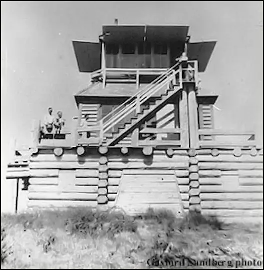
- Cab on a tower30 x 32 ft log cabin (1933 per register) with an L-4 cab added in the 1940sThe designs: L-4, R-6
- Built of
- Not recorded
- Built
- 1933
- Height
- Unknown
- Elevation
- 4,097 ft (1,249 m)
- Agency
- U.S. Forest Service, Siuslaw National Forest
- Land
- Federal land
- Location
- Benton County, Oregon
- Coordinates
- 44.50436, −123.55246
- Registers
- This entry
- VerifiedResearched, then checked independently. Updated 9 Oct 2026.
- Firefinder id
us-or-marys-peak
View from the cab
What the lookout saw from its cab: every ridge out to about 93 miles, the named peaks in sight, and other fire lookouts within view, worked out from terrain data in your browser.
This lookout is gone. The view is reconstructed from its recorded site and a typical height for a lookout like it.
Downloads about 3.6 MB of terrain data the first time.
Or see what it could see on the map: the ground in its line of sight.
History
Then and now
- 1915 StaffedSummer fire watch from a tent on the summit, with a telephone line built up to itSource: oregonlookouts.weebly.com
- No record between 1915 and 1933
- 1933 Built30 x 32 ft log cabin per register and Kamstra. Other sources date the first structure differentlySources: firetower.org, firelookout.com
- 1937 First staffedForest Service station reported in operation on the summit; Kemnow calls Ken Burkholder the first lookoutSource: oregonlookouts.weebly.com
- 1942 BuiltBPA report says the Civilian Conservation Corps constructed a fire lookoutSource: bpa.gov
- No record between 1942 and 1959
- 1959 Replaced by a new structureBPA: log structure deteriorated and was demolished and replaced. Register: a 41 ft R-6 flat tower built this yearSources: firetower.org, bpa.gov
- 1961 EventBPA microwave radio station largely constructed at the summit (not a lookout)Source: bpa.gov
- 1962 DestroyedRegister: the 1959 tower was destroyed in the Columbus Day 1962 windstormSource: firetower.org
- 1963 BuiltTourist vista center with lookout quarters on the top floor; register says used for emergencies in the 1970s and removed before 1980Source: firetower.org
- No record between 1963 and 2010
- 2010 Added to the Former Fire Lookout Sites RegisterDate registered per FFLOS detail page: November 11, 2010Source: FFLOS register entry
- TodayGoneThe lookout no longer stands. Only the site is left. When it came down is not recorded.
Old maps of this spot
USGS topographic maps from the years a lookout stood may show it, often as a small symbol labelled “Lookout”. See the old topo maps around it on the Firefinder map, or find every scanned sheet of this spot on USGS TopoView (opens another site) (click the spot there to list them, with dates and downloads).
Story
Researched 9 Oct 2026, fact-checked.
Marys Peak is the highest summit in Oregon's Coast Range.1 A fire watch was on its summit as early as 1915.2 That year a telephone line was being built up to the top, and M.P. Burnett, who went by Telt, was furnished a tent and a flagpole to watch for fires.2
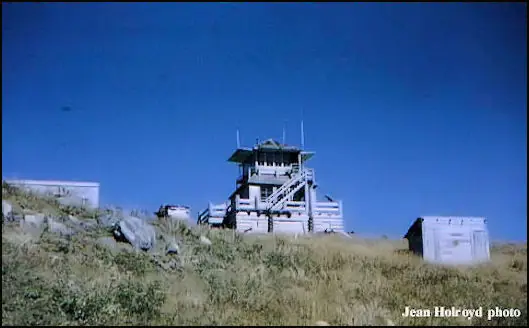
The first cabin is harder to date, and the sources disagree. The register and Rex Kamstra's page say a 30-by-32-foot log cabin was built in 1933, with an L-4 cab added at the top in the 1940s.3,4 A July 1937 newspaper item reports that a Forest Service station went into operation on the summit, and that one man would be stationed there at all times.2 The BPA's historic report says the Civilian Conservation Corps built a fire lookout in 1942.5 Kemnow's page calls Ken Burkholder the first lookout on the peak, which conflicts with the 1915 watch.2
The register describes a 41-foot treated timber tower built in 1959 and destroyed in the Columbus Day windstorm of 1962.3 The BPA report says instead that the log structure had deteriorated by 1959 and was demolished and replaced.5 Kamstra's page gives the lookout's span as 1933 to 1959.4 In 1963 a tourist vista center with lookout quarters on its top floor was built.3 The register says it was used for emergencies in the 1970s and removed before 1980.3
As the BPA's historic report describes the summit, a microwave radio station largely built in 1961 stands there, with a Forest Service communication building and an antenna tower beside it, inside the Mary's Peak Scenic-Botanic Area.5 A visitor guide says the Forest Service leaves the paved access road open year-round, though it is not maintained in winter, and that visitors can walk to the summit on Summit Trail #1388, 1.6 miles round trip.1 We found no source that describes any remains of the lookout buildings on the summit.
- Marys Peak, Outdoor Pilgrim, https://outdoorpilgrim.com/oregon-cohp-marys-peak/ (accessed 2026-10-09). ↩
- Mary's Peak - Forest Lookouts, Forest Lookouts (Ron Kemnow), https://oregonlookouts.weebly.com/marys-peak.html (accessed 2026-10-09). ↩
- Marys Peak Lookout Site, Former Fire Lookout Sites Register, http://firetower.org/lookouts/us/or/marys-peak-lookout-site/ (accessed 2026-10-09). ↩
- Marys Peak Fire Lookout Tower, Firelookout.com (Rex Kamstra), https://www.firelookout.com/or/maryspeak.html (accessed 2026-10-09). ↩
- BPA Microwave Radio Stations, Mary's Peak historic resources form, Bonneville Power Administration, https://www.bpa.gov/-/media/Aep/efw/nepa/completed/marys-peak-communications-site/bpa-communications-site-at-marys-peak-oregon-historic-sites-form.pdf (accessed 2026-10-09). ↩
Photos
Photos keep their own rights and are shown with credit. Is one of these yours? You can ask for a different credit or for removal.
Sources
- Former Fire Lookout Sites Register (FFLOS) (opens another site) Gave us: name, location, county, elevation, register numbers, agency, ownership, dates, photos, links Former Fire Lookout Sites Register (firetower.org) · All rights reserved (American Resources, Inc.); facts extracted only, no prose copied. · retrieved 4 Oct 2026
- Forest Fire Lookout Association (FFLA) - US lookout lists (opens another site) Gave us: type, status, register numbers, links Forest Fire Lookout Association (firelookout.org) · No licence stated; facts extracted only, no prose copied. · retrieved 8 Oct 2026
- firelookout.com -- Rex Kamstra's Forest Fire Lookout Page (opens another site) Gave us: links firelookout.com · No licence stated on the site; facts only (coordinates, elevation, built/destroyed years, design, agency). Photos mirrored with the site's stated credit. · retrieved 4 Oct 2026
- FOREST LOOKOUTS -- western US (Ron Kemnow's weebly sites) (opens another site) Gave us: links Ron Kemnow's Forest Lookouts sites (westlookouts, californialookouts, idaholookouts, montanalookouts, oregonlookouts and washingtonlookouts .weebly.com) · No licence stated; facts only (county, land manager, status word, coordinates where the page's own map widget gives them, township-range-section, height and design hints, links). The site's own newspaper quotes, citations and narrative are not reproduced. · retrieved 8 Oct 2026
- Firefinder research Gave us: summary, design, status, agency, access, visiting details, dates, links, fact-check Firefinder research (sources cited in the story footnotes) · Our own research notes; each fact cites its source in the lookout's story
More about this lookout elsewhere
- FFLOS register entry US 718 (firetower.org) (opens another site)
- Marys Peak (Outdoor Pilgrim) (opens another site)
- BPA Microwave Radio Stations, Mary's Peak historic resources form (Bonneville Power Administration) (opens another site)
- FFLA Oregon lookout list (firelookout.org) (opens another site)
- Marys Peak on firelookout.com (Rex Kamstra) (opens another site)
- Mary's Peak on Forest Lookouts, western US (Ron Kemnow) (opens another site)
Firefinder takes facts (places, dates, numbers) from these sources and writes its own words. See all sources and licences.