Fire lookout · Coos County, Oregon
Mount Bolivar Lookout Site
Siskiyou NF summit lookout: 1914 shake cabin, 1928 D-6 cab, 1955 10-ft L-4 tower; removed 1958; a Forest Service trail and 1984 plaque are on the summit today.
- Gone
- Open to the public
- Verified
Gone: The lookout no longer stands. Only the site is left. Tower removed in 1958; a summit plaque and the trail remain, and no source describes lookout remains
Visit & stay
Gone: site only. The lookout no longer stands, so there is nothing to climb or rent. You may still be able to visit the site.
Access
Open to the public. Mt. Bolivar Trail #1259 is open to hiking only, in the Wild Rogue Wilderness; 1.4 miles one way
- Road to the top?
- Unknown
- Trail
- 1.4 miles one way, hiking only; drive from Powers via County Road 90, Forest Road 33 and Forest Road 3348
Facts
- Status
- Built of
- Not recorded
- Built
- 1914
- Height
- 10 ft (3.0 m)
- Elevation
- 4,319 ft (1,316 m)
- Agency
- U.S. Forest Service
- Land
- Federal land
- Location
- Coos County, Oregon
- Coordinates
- 42.79176, −123.83623
- Registers
- This entry
- VerifiedResearched, then checked independently. Updated 9 Oct 2026.
- Firefinder id
us-or-mount-bolivar
View from the cab
What the lookout saw from its cab: every ridge out to about 93 miles, the named peaks in sight, and other fire lookouts within view, worked out from terrain data in your browser.
This lookout is gone. The view is reconstructed from its recorded site and its recorded height.
Downloads about 3.8 MB of terrain data the first time.
Or see what it could see on the map: the ground in its line of sight.
History
Then and now
- 1914 BuiltShake cabin, 12 feet square, completed by November 1914; corners anchored to bedrock with telephone wireSources: firetower.org, firelookout.com, oregonlookouts.weebly.com
- 1914 FireSmall smoke seen June 18 while the fire finder was installed; by August the lookout had reported 22 fires (8 inside, 14 outside the forest)Source: oregonlookouts.weebly.com
- 1914 First staffedDistrict Ranger R.I. Helm planned to train Guard Price on the map and sighting deviceSource: oregonlookouts.weebly.com
- 1915 Event1,600-gallon water tank erected for the lookoutSource: oregonlookouts.weebly.com
- 1916 EventSnow slide carried the water tank about 300 feet down the hillsideSource: oregonlookouts.weebly.com
- 1928 Replaced by a new structureD-6 style house replaced the shake cabin; lumber cut in Grants Pass and packed about 20 miles on horseback; set on a 10-foot towerSources: firetower.org, firelookout.com, oregonlookouts.weebly.com
- 1934 StaffedAndrew Flynn, formerly a clerk at CCC district headquarters, received the lookout position near PowersSource: oregonlookouts.weebly.com
- 1941 StaffedStation staffed 120 days; reporting station the Powers Ranger StationSource: oregonlookouts.weebly.com
- 1942 EventAircraft Warning Service station active March 10 to July 16; Roseburg Filter Center listedSource: oregonlookouts.weebly.com
- 1955 Replaced by a new structureNew 10-foot L-4 tower (firetower.org and firelookout.com); the Oregon lookouts history dates the new house to 1957 after a July 30, 1955 report of bids being readiedSources: firetower.org, firelookout.com, oregonlookouts.weebly.com
- 1958 RemovedLookout building and tower removed; all three sources give 1958Sources: firetower.org, firelookout.com, oregonlookouts.weebly.com
- No record between 1958 and 2010
- 2010 Added to the Former Fire Lookout Sites RegisterDate registered per FFLOS detail page: November 23, 2010Source: FFLOS register entry
- TodayGoneThe lookout no longer stands. Only the site is left.
Old maps of this spot
USGS topographic maps from the years a lookout stood may show it, often as a small symbol labelled “Lookout”. See the old topo maps around it on the Firefinder map, or find every scanned sheet of this spot on USGS TopoView (opens another site) (click the spot there to list them, with dates and downloads).
Story
Researched 9 Oct 2026, fact-checked.
Mount Bolivar is the highest point in Coos County, and a fire lookout stood on its summit from 1914 until 1958.1,2
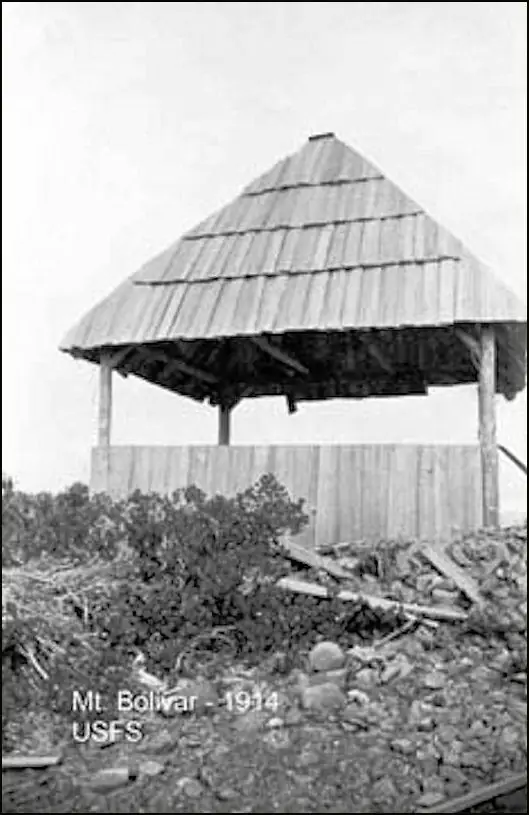
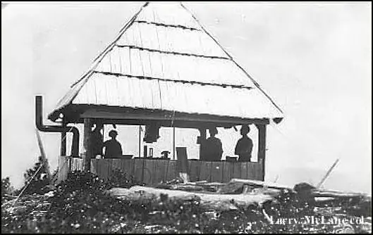
The first lookout was a shake cabin, 12 feet square, completed by November 1914.2,3 The summit is solid rock, and each corner was anchored to it with telephone wire.3 A guard carried loads up the steep slope every time he went to the lookout.3
In June 1914 District Ranger R.I. Helm planned to train Guard Price on the map and sighting device.3 That same month a small smoke appeared while a fire finder was being installed there, and it died out on its own.3 By August 1914 the lookout had reported 22 fires, eight inside the forest and fourteen outside.3
A 1,600-gallon water tank went up for the lookout in 1915, but the next spring a snow slide carried it about 300 feet down the hillside.3 In 1928 a D-6 style house replaced the shake cabin.2,3 Most of its materials came from Grants Pass and were carried about 20 miles on horseback.3
In 1934 Andrew Flynn, who had spent six months as a clerk at CCC district headquarters, was given a Forest Service lookout post on Bolivar near Powers.3 By 1941 the station was staffed for 120 days, reporting through the Powers Ranger Station.3 In 1942 the summit served briefly as an Aircraft Warning Service post, active from March 10 to July 16, with the Roseburg Filter Center listed.3
In 1955 the Forest Service was getting ready to receive bids for a new lookout building, and the Former Fire Lookout Sites register says a 10-foot L-4 tower went up that year.3,2,4 The Oregon lookouts history dates the new house to 1957.3 All three sources date its removal to 1958.2,4,3
Today the Forest Service's Mt. Bolivar Trail #1259 runs 1.4 miles one way to the summit, which the agency says was once home to a fire lookout.1 A plaque on the summit, a gift from Venezuela, dates from a 1984 ceremony.1 No source we found describes what, if anything, remains of the lookout building.1 Only hikers may use the path, which runs through the Wild Rogue Wilderness, and the drive to the trailhead goes through Powers.1
- Mt. Bolivar Trail #1259, USDA Forest Service, Rogue River-Siskiyou National Forest, https://www.fs.usda.gov/r06/rogue-siskiyou/recreation/trails/mt-bolivar-trail-1259 (accessed 2026-10-09). ↩
- Mount Bolivar Lookout Site, Former Fire Lookout Sites, http://firetower.org/lookouts/us/or/mount-bolivar-lookout-site/ (accessed 2026-10-09). ↩
- Mount Bolivar, Forest Lookouts (Oregon), https://oregonlookouts.weebly.com/mount-bolivar.html (accessed 2026-10-09). ↩
- Mt. Bolivar Fire Lookout Cabin, firelookout.com, https://www.firelookout.com/or/bolivar.html (accessed 2026-10-09). ↩
Photos
Photos keep their own rights and are shown with credit. Is one of these yours? You can ask for a different credit or for removal.
Sources
- Former Fire Lookout Sites Register (FFLOS) (opens another site) Gave us: name, location, county, elevation, register numbers, agency, ownership, dates, photos, links Former Fire Lookout Sites Register (firetower.org) · All rights reserved (American Resources, Inc.); facts extracted only, no prose copied. · retrieved 4 Oct 2026
- Forest Fire Lookout Association (FFLA) - US lookout lists (opens another site) Gave us: type, status, register numbers, links Forest Fire Lookout Association (firelookout.org) · No licence stated; facts extracted only, no prose copied. · retrieved 8 Oct 2026
- firelookout.com -- Rex Kamstra's Forest Fire Lookout Page (opens another site) Gave us: links firelookout.com · No licence stated on the site; facts only (coordinates, elevation, built/destroyed years, design, agency). Photos mirrored with the site's stated credit. · retrieved 4 Oct 2026
- FOREST LOOKOUTS -- western US (Ron Kemnow's weebly sites) (opens another site) Gave us: design, height, links Ron Kemnow's Forest Lookouts sites (westlookouts, californialookouts, idaholookouts, montanalookouts, oregonlookouts and washingtonlookouts .weebly.com) · No licence stated; facts only (county, land manager, status word, coordinates where the page's own map widget gives them, township-range-section, height and design hints, links). The site's own newspaper quotes, citations and narrative are not reproduced. · retrieved 8 Oct 2026
- Firefinder research Gave us: summary, design, height, status, agency, access, visiting details, dates, links, fact-check Firefinder research (sources cited in the story footnotes) · Our own research notes; each fact cites its source in the lookout's story
More about this lookout elsewhere
- FFLOS register entry US 768 (firetower.org) (opens another site)
- Mt. Bolivar Trail #1259 (USDA Forest Service, Rogue River-Siskiyou National Forest) (opens another site)
- FFLA Oregon lookout list (firelookout.org) (opens another site)
- Mt. Bolivar on firelookout.com (Rex Kamstra) (opens another site)
- Mount Bolivar on Forest Lookouts, western US (Ron Kemnow) (opens another site)
Firefinder takes facts (places, dates, numbers) from these sources and writes its own words. See all sources and licences.