Fire lookout · Klamath County, Oregon
Mount Scott Lookout
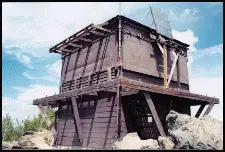
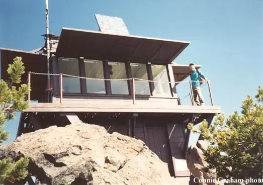
A 1952 two-story L-4 lookout on Crater Lake's highest summit, no longer staffed and now used for USGS seismic equipment and emergencies.
- Standing
- Restricted access
- Verified
Visit & stay
Not rentable. As far as we know, this lookout cannot be booked for overnight stays.
Access
Restricted access
Access is seasonal, gated or needs a permit. Check before you go. Maintained for emergency use; houses USGS seismic monitoring equipment. The sources read do not say whether visitors may go inside the cab.
- Can you climb it?
- Unknown
- Road to the top?
- No, you have to hike
- Trail
- About 2.5 miles with many switchbacks, starting on Rim Drive and ending at the tower on the summit. Trailhead at 7,683 ft (Wikipedia).
- Staffing
- Unknown
Facts
- Status
- Type
- Two-story buildingTwo-story modified L-4, about 14 x 14 ft, with a fold-up catwalkThe designs: L-4, Cupola house
- Built of
- WoodGoing by its design; no source says so in words.
- Built
- 1924
- Height
- 14 ft (4.3 m)
- Elevation
- 8,806 ft (2,684 m)
- Agency
- U.S. Dept. of the Interior; National Park Service is the cooperator (Crater Lake National Park)
- Land
- Federal land
- Location
- Klamath County, Oregon
- Coordinates
- 42.92323, −122.01617
- Registers
- This entry
- VerifiedResearched, then checked independently. Updated 8 Oct 2026.
- Firefinder id
us-or-mount-scott
View from the cab
What you see from the cab: every ridge out to about 93 miles, the named peaks in sight, and other fire lookouts within view, worked out from terrain data in your browser.
Downloads about 3.8 MB of terrain data the first time.
Or see what it could see on the map: the ground in its line of sight.
History
Then and now
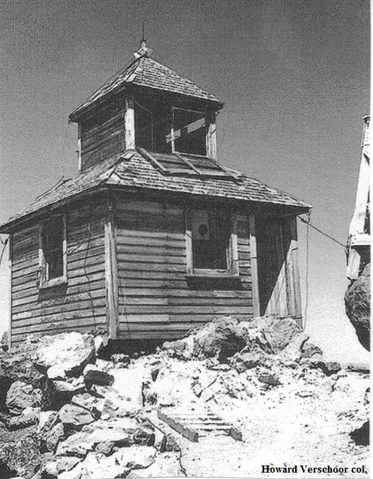
- 1924 BuiltFirst structure, a cupola cabin. Register gives 1924; firelookout.com says about 1923; a history page places a three-way agreement in winter 1924/25Sources: nhlr.org, firelookout.com, cherylhill.net
- 1928 FireIn August 1928 the lookout reported seven fires on the reservation, one on the Crater National Forest and two on Association territorySource: willhiteweb.com
- 1929 BuiltMaterials delivered to build the lookout house; a lookout offered to build it and did much of the work by the end of the fire seasonSource: willhiteweb.com
- 1935 EventStill a cooperative lookout between Crater Lake National Park and the Klamath district of the Rogue River National ForestSource: willhiteweb.com
- No record between 1935 and 1952
- 1952 Built'Built' field on NHLR detail pageSource: NHLR register entry
- 1952 Replaced by a new structureCurrent two-story structure replaced the cupola, which had become too loose to plot fire locationsSources: nhlr.org, firelookout.com, cherylhill.net
- No record between 1952 and 2002
- 2002 Added to the National Historic Lookout RegisterRegistered on the National Historic Lookout Register, December 1, 2002Source: nhlr.org
- 2010 Condition assessmentSMS visited with the Park historian to assess the building; no time was left for work.Source: sandmountain.org
- TodayStandingIt still stands, as far as our sources know.
Old maps of this spot
USGS topographic maps from the years a lookout stood may show it, often as a small symbol labelled “Lookout”. See the old topo maps around it on the Firefinder map, or find every scanned sheet of this spot on USGS TopoView (opens another site) (click the spot there to list them, with dates and downloads).
Story
Researched 8 Oct 2026, fact-checked.
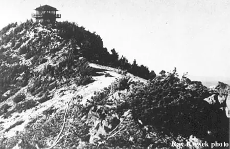
Mount Scott is the highest point in Crater Lake National Park.1 The first summit lookout was a cupola cabin from the 1920s, and the sources do not agree on the exact year.2,3,4 Firelookout.com says about 1923, and the register says 1924.3,4 A history page that draws on park files says a three-way agreement to build a lookout was made in the winter of 1924/25, and that materials for the lookout house were being delivered in 1929.5
The lookout was still a shared post in the 1930s. In 1935 it was a cooperative lookout between the park and the Klamath district of the Rogue River National Forest.5 The same history page records that in August 1928 the lookout reported seven fires on the reservation, one on the Crater National Forest, and two on Association territory.5
In its final 15 years the cupola was so loose that a fire's location could not be plotted on a windy day, the register says.4 The cupola gave way in 1952 to the present two-story structure, a modified L-4 with a fold-up catwalk.4,2
That 1952 lookout is no longer staffed, and it now holds USGS seismic monitoring gear.2 Firelookout.com describes the present NPS cab as available for emergencies.3 The register says it is now kept up for emergency use.4
The summit trail starts on Rim Drive and runs about 2.5 miles, with many switchbacks, to the tower.1 The sources I read do not say whether visitors may go inside the cab, so check with Crater Lake National Park before you plan a trip.
- Mount Scott (Klamath County, Oregon), Wikipedia, https://en.wikipedia.org/wiki/Mount_Scott_(Klamath_County,_Oregon) (accessed 2026-10-08). ↩
- Mt. Scott, Every Lookout in Oregon, Cheryl Hill blog, https://cherylhill.net/firelookouts/2024/09/28/mt-scott/ (accessed 2026-10-08). ↩
- Mt. Scott Fire Lookout Tower, Firelookout.com, https://www.firelookout.com/or/mtscott.html (accessed 2026-10-08). ↩
- Mount Scott Lookout, National Historic Lookout Register, http://nhlr.org/lookouts/us/or/mount-scott-lookout/ (accessed 2026-10-08). ↩
- Mount Scott Lookout History, Willhite Web, https://willhiteweb.com/crater_lake_national_park/mount_scott_lookout/history_102.htm (accessed 2026-10-08). ↩
Photos
Photos keep their own rights and are shown with credit. Is one of these yours? You can ask for a different credit or for removal.
Sources
- National Historic Lookout Register (NHLR) (opens another site) Gave us: name, location, county, elevation, what it is built of, register numbers, agency, dates, photos, links National Historic Lookout Register (nhlr.org) · All rights reserved (American Resources, Inc.); facts extracted only, no prose copied. · retrieved 4 Oct 2026
- Forest Fire Lookout Association (FFLA) - US lookout lists (opens another site) Gave us: type, status, register numbers, links Forest Fire Lookout Association (firelookout.org) · No licence stated; facts extracted only, no prose copied. · retrieved 8 Oct 2026
- firelookout.com -- Rex Kamstra's Forest Fire Lookout Page (opens another site) Gave us: ownership, photos, links firelookout.com · No licence stated on the site; facts only (coordinates, elevation, built/destroyed years, design, agency). Photos mirrored with the site's stated credit. · retrieved 4 Oct 2026
- Sand Mountain Society (opens another site) Gave us: dates, links Sand Mountain Society (sandmountain.org) · No licence stated; facts only (dates, names, dimensions, the kind of work done). Every note is our own wording and every event links to the Sand Mountain Society page it comes from. Positions are copied from the NHLR and FFLOS records. · retrieved 8 Oct 2026
- OpenStreetMap -- fire lookout structures (opens another site) Gave us: links © OpenStreetMap contributors · ODbL 1.0. (c) OpenStreetMap contributors. · retrieved 4 Oct 2026
- FOREST LOOKOUTS -- western US (Ron Kemnow's weebly sites) (opens another site) Gave us: height, links Ron Kemnow's Forest Lookouts sites (westlookouts, californialookouts, idaholookouts, montanalookouts, oregonlookouts and washingtonlookouts .weebly.com) · No licence stated; facts only (county, land manager, status word, coordinates where the page's own map widget gives them, township-range-section, height and design hints, links). The site's own newspaper quotes, citations and narrative are not reproduced. · retrieved 8 Oct 2026
- Every Lookout in Oregon (Cheryl Hill) (opens another site) Gave us: links Every Lookout in Oregon (Cheryl Hill, cherylhill.net) · No licence stated; facts only (name, agency, elevation, year built, design and height, status word, links). Posts' narrative and photos are not reproduced. · retrieved 8 Oct 2026
- Firefinder research Gave us: summary, design, agency, access, visiting details, dates, links, fact-check Firefinder research (sources cited in the story footnotes) · Our own research notes; each fact cites its source in the lookout's story
More about this lookout elsewhere
- NHLR register entry US 402 (nhlr.org) (opens another site)
- Mt. Scott, Every Lookout in Oregon (Cheryl Hill blog) (opens another site)
- Mount Scott Lookout History (Willhite Web) (opens another site)
- Mount Scott (Klamath County, Oregon) (Wikipedia) (opens another site)
- FFLA Oregon lookout list (firelookout.org) (opens another site)
- Sand Mountain Society: work on Mount Scott Lookout (opens another site)
- Mt. Scott on firelookout.com (Rex Kamstra) (opens another site)
- Mount Scott on Forest Lookouts, western US (Ron Kemnow) (opens another site)
- Mt. Scott on Every Lookout in Oregon (Cheryl Hill) (opens another site)
- OpenStreetMap way 741978746 (opens another site)
Firefinder takes facts (places, dates, numbers) from these sources and writes its own words. See all sources and licences.