Fire lookout · Josephine County, Oregon
Onion Mountain Lookout
Also known as Onion Mt.
An early-1900s lookout site in southwest Oregon got its current 1952 L-4 tower, which was staffed into the 1990s and again in 2007 but now sits idle and closed to reservations.
- Standing
- Rentable
- Restricted access
- Verified
Visit & stay
You can rent this lookout for overnight stays through recreation.gov.
Overview THIS FACILITY IS CLOSED TO RESERVATIONS UNTIL FURTHER NOTICE Onion Mountain lookout sits atop a 12-foot tower at an elevation of 4,438 feet, offering guests expansive mountain views in southwestern Oregon. The original Onion Mountain Lookout was a raised platform, built on top of a tower in 1916. In 1924, a second lookout without a tower was built on site. The current structure was placed on site in 1952 and served as a fire lookout and Aircraft Warning Service observation station. The lookout offers a unique lodging experience in the Rouge River-Siskiyou National Forest, but visitors are required to bring a few of their own supplies to enjoy a safe and comfortable stay. Recreation Hiking, mountain biking, stargazing and wildlife viewing are popular among guests to this lookout. On trails throughout the area, hikers will enjoy mountain views, old-growth forest canopies and natural pools for swimming. The lookout is located near the Taylor Creek/Onion Way mountain loop, a trail popular among mountain biking enthusiasts. At night, the rustic cabin becomes an astronomer's heaven as the expansive night sky is littered with a dazzling display of stars and planets. Facilities The cabin offers a 14 x 14 foot room with large windows on all sides. It is designed for one or two people, and is furnished with a bed with a mattress, a table and chairs. Amenities include a propane cooking stove, refrigerator, and lanterns. There is no propane heater. There is also no water on site, so visitors must bring sufficient supplies for drinking, cooking and washing. Guests must also provide their own sleeping bags, sleeping pads, towels, dish soap, matches, cooking gear, toilet paper and garbage bags. A primitive vault toilet is located near the lookout as well as space for four or five tents. Natural Features On a clear day, Onion Mountain offers panoramic views of layered mountainous terrain and forest stretching out in all directions. Onion Mountain is named for the tiny wild onions that grow among the rocks at the summit. In early summer, the area is dotted with plumes of Bear Grass, bright yellow Snow Mountain Buckwheat and purple penstemon. Nearby Attractions Visit Crater Lake National Park and learn about its unique natural and cultural history. Reaching depths of 1,943 feet, Crater Lake is the deepest lake in the United States and one of the 10 deepest lakes in the world. Oregon Caves National Monument is within a hour's drive.
Book on recreation.gov (opens recreation.gov)
Rental details from recreation.gov, checked 19 Oct 2026. Rules, fees and seasons change, so confirm on the booking page before you go. Data source: ridb.recreation.gov
Access
Restricted access
Access is seasonal, gated or needs a permit. Check before you go. A Forest Service recreation rental, but currently closed to reservations; when open, access is by key pickup from the Wild Rivers Ranger District office in Grants Pass.
- Can you climb it?
- Yes
- Road to the top?
- Yes, you can drive up
- Trail
- Eight miles of gravel road off Riverbanks Road south of Grants Pass; not recommended for families with toddlers because of the tower.
- Staffing
- Unknown
Facts
- Status
- Built of
- Wood
- Also served as
- Aircraft Warning Service postDuring the Second World War it was staffed to spot and report aircraft.
- Built
- 1915 sources disagree
- Height
- 11 ft (3.4 m)
- Elevation
- 4,334 ft (1,321 m)
- Agency
- U.S. Forest Service
- Land
- Federal land
- Location
- Josephine County, Oregon
- Coordinates
- 42.45460, −123.61490
- Registers
- This entry
- VerifiedResearched, then checked independently. Updated 19 Oct 2026.
- Firefinder id
us-or-onion-mountain
View from the cab
What you see from the cab: every ridge out to about 93 miles, the named peaks in sight, and other fire lookouts within view, worked out from terrain data in your browser.
Downloads about 3.5 MB of terrain data the first time.
Or see what it could see on the map: the ground in its line of sight.
History
Then and now
- 1915 BuiltFirst lookout: a 20-foot platform tower, developed about 1915-1916.Sources: nhlr.org, firelookout.com
- 1924 Replaced by a new structureA D-6 cupola replaced the platform tower.Sources: nhlr.org, firelookout.com
- No record between 1924 and 1942
- 1942 AlteredAn Aircraft Warning Service observation cabin was built on site.Sources: nhlr.org, firelookout.com, recreation.gov
- 1952 BuiltPresent 10-12 foot treated-timber L-4 tower built.Sources: nhlr.org, firelookout.com, recreation.gov
- No record between 1952 and 1990
- 1990 StaffedStaffed into the 1990s, per NHLR and Firelookout.com.Sources: nhlr.org, firelookout.com
- 2001 Added to the National Historic Lookout RegisterListed on the National Historic Lookout Register September 1, 2001.Source: nhlr.org
- 2004 RestoredInterior floor redone and some painting done.Source: firelookout.org
- 2007 StaffedFirelookout.com says the lookout was staffed again in 2007 after a stint on the rental program.Source: firelookout.com
- TodayStandingIt still stands, as far as our sources know.
Old maps of this spot
USGS topographic maps from the years a lookout stood may show it, often as a small symbol labelled “Lookout”. See the old topo maps around it on the Firefinder map, or find every scanned sheet of this spot on USGS TopoView (opens another site) (click the spot there to list them, with dates and downloads).
Story
Researched 4 Oct 2026, fact-checked.
Onion Mountain's lookout history goes back further than its current building. Around 1915 or 1916, the Forest Service put up a 20-foot platform tower on the summit; a D-6 cupola replaced it in 1924.1,2 During World War II, in 1942, an Aircraft Warning Service cabin was added to the site.1,2,3 The present structure — a 10-to-12-foot treated-timber L-4 tower — went up in 1952 and is the building that still stands on the mountain today.1,2,3
The lookout stayed staffed through the 1990s.1,2 Accounts differ on exactly what happened next: Firelookout.com reports that it went onto the Forest Service's rental program, came back into staffed use briefly in 2007, saw continued use into the early 2010s, and has sat unused since.2 The Forest Service's own Recreation.gov page lists it as a rental cabin in the Rogue River-Siskiyou National Forest, but opens with a notice that the facility is closed to reservations until further notice — consistent with Firelookout.com's account of the site currently sitting idle.2,3
Getting there is not casual. Reaching the lookout requires roughly an eight-mile drive on gravel Forest Service roads off Riverbanks Road south of Grants Pass, and when it is open for rental, guests must pick up a key in person from the Wild Rivers Ranger District office in Grants Pass several days ahead of arrival.3 The Forest Service warns that the tower makes the cabin unsuitable for families with young children, though pets are welcome.3 From the catwalk, visitors get wide views across southwestern Oregon, with the Oregon Caves within about an hour's drive and Crater Lake National Park also reachable nearby.3
- Onion Mountain Lookout, National Historic Lookout Register, http://nhlr.org/lookouts/us/or/onion-mountain-lookout/ (accessed 2026-10-04). ↩
- Onion Mtn. Fire Lookout Tower, Fire Lookout, https://www.firelookout.com/or/onionmtn.html (accessed 2026-10-04). ↩
- Onion Mountain Lookout, Recreation.gov, https://www.recreation.gov/camping/campgrounds/234163 (accessed 2026-10-04). ↩
Photos
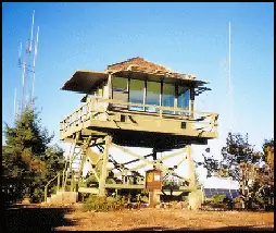
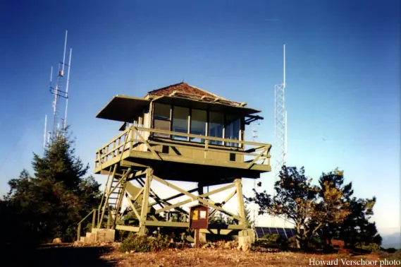
Photos keep their own rights and are shown with credit. Is one of these yours? You can ask for a different credit or for removal.
Where sources disagree
We show disagreements between sources instead of quietly picking one. If you know which is right, please tell us.
Sources disagree on the year it was built.
- NHLR: 1952
- firelookout.com -- Rex Kamstra's Forest Fire Lookout Page: 1942
- Every Lookout in Oregon (Cheryl Hill): 1952
Sources give different build years. Often one counts the first lookout on the site and another the structure there now.
Sources
- National Historic Lookout Register (NHLR) (opens another site) Gave us: name, location, county, elevation, what it is built of, wartime use, register numbers, agency, dates, photos, links National Historic Lookout Register (nhlr.org) · All rights reserved (American Resources, Inc.); facts extracted only, no prose copied. · retrieved 4 Oct 2026
- Forest Fire Lookout Association (FFLA) - US lookout lists (opens another site) Gave us: type, status, register numbers, links Forest Fire Lookout Association (firelookout.org) · No licence stated; facts extracted only, no prose copied. · retrieved 8 Oct 2026
- Recreation Information Database (recreation.gov) (opens another site) Gave us: ownership, access, rental details, links Data source: ridb.recreation.gov · Public data from the US government · retrieved 19 Oct 2026
- firelookout.com -- Rex Kamstra's Forest Fire Lookout Page (opens another site) Gave us: design, photos, links firelookout.com · No licence stated on the site; facts only (coordinates, elevation, built/destroyed years, design, agency). Photos mirrored with the site's stated credit. · retrieved 4 Oct 2026
- Forest Fire Lookout Association chapter reports (opens another site) Gave us: dates, links Forest Fire Lookout Association, chapter and restoration-grant reports (firelookout.org) · No licence stated; facts only (dates, names, the kind of work done). Every note is our own wording and every event links to the FFLA report it comes from. Positions are copied from the NHLR, FFLOS and FFLA records. · retrieved 8 Oct 2026
- OpenStreetMap -- fire lookout structures (opens another site) Gave us: links © OpenStreetMap contributors · ODbL 1.0. (c) OpenStreetMap contributors. · retrieved 4 Oct 2026
- FOREST LOOKOUTS -- western US (Ron Kemnow's weebly sites) (opens another site) Gave us: height, links Ron Kemnow's Forest Lookouts sites (westlookouts, californialookouts, idaholookouts, montanalookouts, oregonlookouts and washingtonlookouts .weebly.com) · No licence stated; facts only (county, land manager, status word, coordinates where the page's own map widget gives them, township-range-section, height and design hints, links). The site's own newspaper quotes, citations and narrative are not reproduced. · retrieved 8 Oct 2026
- Every Lookout in Oregon (Cheryl Hill) (opens another site) Gave us: register numbers, links Every Lookout in Oregon (Cheryl Hill, cherylhill.net) · No licence stated; facts only (name, agency, elevation, year built, design and height, status word, links). Posts' narrative and photos are not reproduced. · retrieved 8 Oct 2026
- Firefinder research Gave us: summary, design, height, status, agency, access, visiting details, dates, links, fact-check Firefinder research (sources cited in the story footnotes) · Our own research notes; each fact cites its source in the lookout's story
More about this lookout elsewhere
- NHLR register entry US 393 (nhlr.org) (opens another site)
- Recreation.gov listing (opens another site)
- FFLA Oregon lookout list (firelookout.org) (opens another site)
- Forest Fire Lookout Association chapter reports: work on Onion Mountain Lookout (opens another site)
- Onion Mtn. on firelookout.com (Rex Kamstra) (opens another site)
- Onion Mountain on Forest Lookouts, western US (Ron Kemnow) (opens another site)
- Onion Mountain on Every Lookout in Oregon (Cheryl Hill) (opens another site)
- OpenStreetMap way 582134975 (opens another site)
Firefinder takes facts (places, dates, numbers) from these sources and writes its own words. See all sources and licences.