Fire lookout · Clackamas County, Oregon
Pechuck Mountain Lookout
Also known as Pechuck Lookout, Pechuk Lookout
The only stone fire lookout left in Oregon, built 1932 near Molalla, unstaffed since the early 1960s, restored by volunteers starting 1991, and open to the public to visit and stay overnight free.
- Standing
- Open to the public
- Verified
Visit & stay
Not rentable. As far as we know, this lookout cannot be booked for overnight stays.
Access
Open to the public. Open to the public for day use and overnight stays, first-come first-served, no permit; reached via a long hike from Rooster Rock Trailhead on the Table Rock Trail, or a steep closed fire road from South Molalla River Road
- Can you climb it?
- Yes
- Road to the top?
- No, you have to hike
- Trail
- Long, difficult hike from Rooster Rock Trailhead (Table Rock Wilderness) or steep closed fire road from South Molalla River Road; good map/orientation skills recommended
- Staffing
- Not staffed (as of 1964)
Facts
- Status
- Type
- Ground-level cabStone-and-wood cupolaThe design: Cupola house
- Built of
- Mixed
- Built
- 1932
- Height
- Unknown
- Elevation
- 4,238 ft (1,292 m)
- Agency
- Bureau of Land Management (formerly Oregon Department of Forestry)
- Land
- Federal land
- Location
- Clackamas County, Oregon
- Coordinates
- 44.93404, −122.29676
- Registers
- This entry
- VerifiedResearched, then checked independently. Updated 8 Oct 2026.
- Firefinder id
us-or-pechuck-mountain
View from the cab
What you see from the cab: every ridge out to about 93 miles, the named peaks in sight, and other fire lookouts within view, worked out from terrain data in your browser.
Downloads about 4.0 MB of terrain data the first time.
Or see what it could see on the map: the ground in its line of sight.
History
Then and now
- 1918 EventFire detection site established with only a primitive rangefinder, no cabin yetSource: blm.gov
- 1932 BuiltStone-and-wood cupola cabin built by John Oblack and an unnamed Portland stonemason, using native stoneSources: blm.gov, sandmountain.org, nhlr.org
- No record between 1932 and 1963
- 1963 Last staffedSand Mountain Society states the lookout was staffed until 1963, under Oregon Department of Forestry managementSource: sandmountain.org
- 1964 ClosedBLM states it was determined in 1964 that Pechuck was no longer needed for fire suppression, due to aerial patrols and better roadsSource: blm.gov
- No record between 1964 and 1990
- 1990 Added to the National Historic Lookout RegisterListed on the National Historic Lookout Register, August 18, 1990, the second site registeredSources: nhlr.org, blm.gov
- 1991 RestoredVolunteer-led re-roofing project begins, organized by Jim Borders with the Molalla community and Sand Mountain Society members Doug Newman, Don Allen, and Bill JoySource: sandmountain.org
- 1992 EventAdded to the World Fire Lookout RegisterSource: blm.gov
- 1995 Restoredfirelookout.com states the lookout was restored in 1995 (a separate or later restoration effort than the 1991 re-roofing)Source: firelookout.com
- TodayStandingIt still stands, as far as our sources know.
Old maps of this spot
USGS topographic maps from the years a lookout stood may show it, often as a small symbol labelled “Lookout”. See the old topo maps around it on the Firefinder map, or find every scanned sheet of this spot on USGS TopoView (opens another site) (click the spot there to list them, with dates and downloads).
Story
Researched 4 Oct 2026, fact-checked.
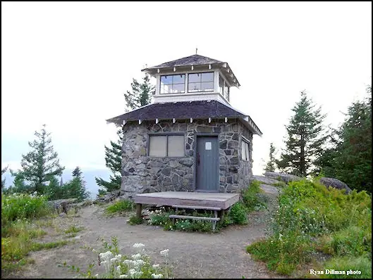
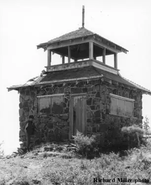
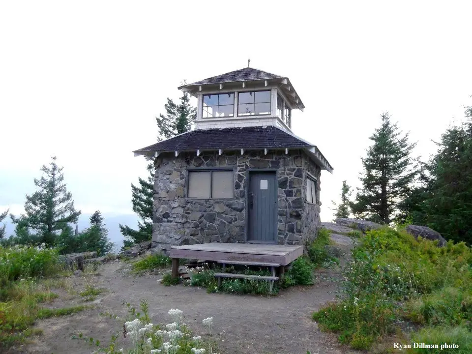
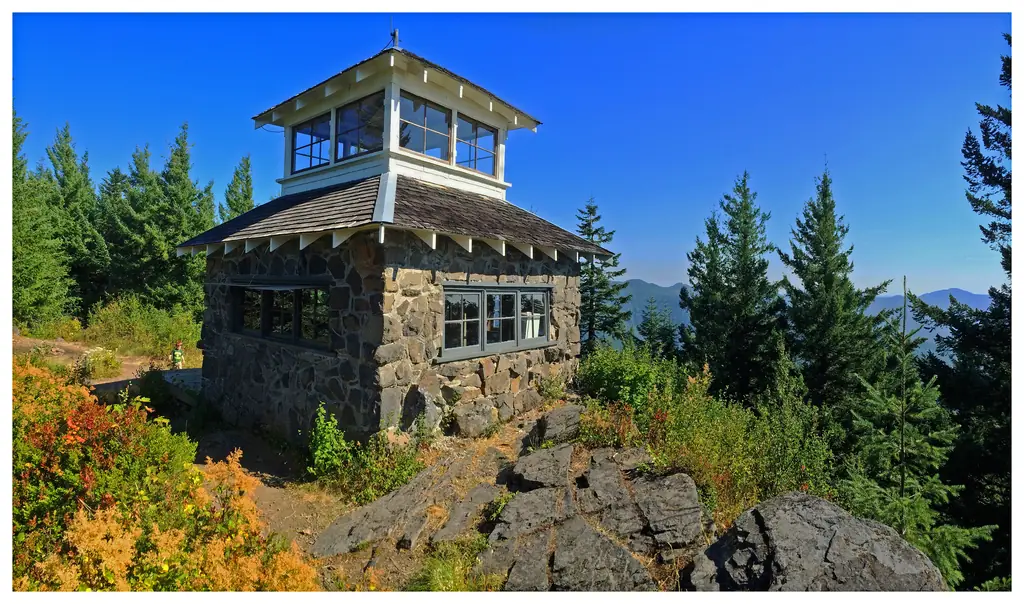
Fire detection began at Pechuck Mountain in 1918, when the site held nothing more than a primitive rangefinder for spotting smoke.1 The stone-and-wood cupola cabin that stands there now came later, built in 1932 by John Oblack, a Czechoslovakian from nearby Molalla, with help from an unnamed stone mason from Portland.1,2 They used native stone quarried close to the site, giving the lookout a look often compared to Timberline Lodge on Mount Hood, and making it the only stone lookout left standing in Oregon.3,1 The lower story served as living quarters for whoever staffed the lookout, while the upper story's windows on all four sides gave a full 360-degree view for spotting fires.1
Pechuck was run by the Oregon Department of Forestry, and sources differ slightly on when staffing ended: one account gives 1963, another says the Forest Service (through what is now BLM) decided in 1964 that the lookout was no longer needed as part of fire detection, as aerial patrols and better roads made ground lookouts less essential.2,1 Either way, it sat unused for decades afterward. According to the National Historic Lookout Register, the building survived mainly because tearing it down would have taken more effort than leaving it alone.3
Restoration work began in 1991, when volunteers organized by Jim Borders and the Molalla area community, with help from Doug Newman, Don Allen and Bill Joy of the Sand Mountain Society, re-roofed the structure during the autumn rains.2 The project was later carried on by a group called Friends of Pechuck.2 The lookout was added to the National Historic Lookout Register in 1990, the second site ever listed there, and to the World Fire Lookout Register in 1992.3,1
Today Pechuck Lookout sits on land managed by the Bureau of Land Management near the south end of the Table Rock Wilderness, and it is open to the public for day visits and overnight stays on a first-come, first-served basis, with no reservation needed.1 The most scenic approach is the long, difficult hike from the Rooster Rock Trailhead on the Table Rock Trail; a steep, closed fire road from South Molalla River Road offers another route in. Good map and orientation skills are recommended either way.1
- Pechuck Lookout, Bureau of Land Management, https://www.blm.gov/visit/pechuck-lookout (accessed 2026-10-04). ↩
- Pechuck Lookout, Sand Mountain Society, https://sandmountain.org/projects/pechuk-lookout/ (accessed 2026-10-04). ↩
- Pechuck Mountain Lookout, National Historic Lookout Register, http://nhlr.org/lookouts/us/or/pechuck-mountain-lookout/ (accessed 2026-10-04). ↩
Photos

Photos keep their own rights and are shown with credit. Is one of these yours? You can ask for a different credit or for removal.
Sources
- National Historic Lookout Register (NHLR) (opens another site) Gave us: name, location, county, elevation, register numbers, agency, dates, photos, links National Historic Lookout Register (nhlr.org) · All rights reserved (American Resources, Inc.); facts extracted only, no prose copied. · retrieved 4 Oct 2026
- Forest Fire Lookout Association (FFLA) - US lookout lists (opens another site) Gave us: type, status, register numbers, links Forest Fire Lookout Association (firelookout.org) · No licence stated; facts extracted only, no prose copied. · retrieved 8 Oct 2026
- Recreation Information Database (recreation.gov) (opens another site) Gave us: what it is built of, ownership, access, links Data source: ridb.recreation.gov · Public data from the US government · retrieved 12 Oct 2026
- firelookout.com -- Rex Kamstra's Forest Fire Lookout Page (opens another site) Gave us: dates, photos, links firelookout.com · No licence stated on the site; facts only (coordinates, elevation, built/destroyed years, design, agency). Photos mirrored with the site's stated credit. · retrieved 4 Oct 2026
- Sand Mountain Society (opens another site) Gave us: design, dates, links Sand Mountain Society (sandmountain.org) · No licence stated; facts only (dates, names, dimensions, the kind of work done). Every note is our own wording and every event links to the Sand Mountain Society page it comes from. Positions are copied from the NHLR and FFLOS records. · retrieved 8 Oct 2026
- Wikidata -- US fire lookout towers (Q748998 and subclasses) (opens another site) Gave us: photos, links Wikidata · CC0 1.0 (Wikidata). Images keep their own Commons licence/credit. · retrieved 4 Oct 2026
- FOREST LOOKOUTS -- western US (Ron Kemnow's weebly sites) (opens another site) Gave us: links Ron Kemnow's Forest Lookouts sites (westlookouts, californialookouts, idaholookouts, montanalookouts, oregonlookouts and washingtonlookouts .weebly.com) · No licence stated; facts only (county, land manager, status word, coordinates where the page's own map widget gives them, township-range-section, height and design hints, links). The site's own newspaper quotes, citations and narrative are not reproduced. · retrieved 8 Oct 2026
- Every Lookout in Oregon (Cheryl Hill) (opens another site) Gave us: register numbers, links Every Lookout in Oregon (Cheryl Hill, cherylhill.net) · No licence stated; facts only (name, agency, elevation, year built, design and height, status word, links). Posts' narrative and photos are not reproduced. · retrieved 8 Oct 2026
- FFLA chapters, affiliates and Friends groups: lookout pages (opens another site) FFLA chapters and Friends groups (each link names the group) · Links to the groups' own pages; facts only from the California-South chapter's tower table (register page, operator, condition). No text or photos reproduced. · retrieved 8 Oct 2026
- Firefinder research Gave us: summary, design, status, agency, access, staffing, visiting details, dates, links, fact-check Firefinder research (sources cited in the story footnotes) · Our own research notes; each fact cites its source in the lookout's story
More about this lookout elsewhere
- NHLR register entry US 2 (nhlr.org) (opens another site)
- NHLR register entry (nhlr.org) (opens another site)
- Pechuck Lookout (Bureau of Land Management) (opens another site)
- FFLA Oregon lookout list (firelookout.org) (opens another site)
- Sand Mountain Society: work on Pechuck Lookout (opens another site)
- View video of Pechuck Mountain Lookout by Terry Musgrove, November 2011 (opens another site)
- Pechuck Mtn. on firelookout.com (Rex Kamstra) (opens another site)
- Pechuck on Forest Lookouts, western US (Ron Kemnow) (opens another site)
- Pechuck Mountain on Every Lookout in Oregon (Cheryl Hill) (opens another site)
- Facility map (opens another site)
- Wikidata item Q86926956 (opens another site)
Firefinder takes facts (places, dates, numbers) from these sources and writes its own words. See all sources and licences.