Fire lookout · Klamath County, Oregon
Pelican Butte Lookout
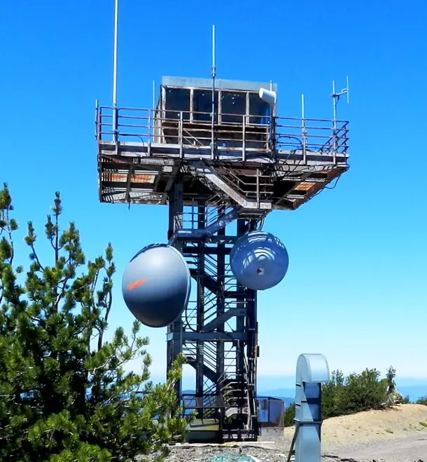
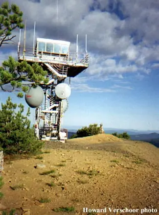
Klamath County tower near Rocky Point with a 1986 metal cab built alongside a cable-company relay; standing, on standby and used only in emergencies.
- Standing
- Restricted access
- Verified
Visit & stay
Not rentable. As far as we know, this lookout cannot be booked for overnight stays.
Access
Restricted access
Access is seasonal, gated or needs a permit. Check before you go. Summit shares use with a communications relay. The cab is on standby and used only in emergencies. Cheryl Hill's list marks the site publicly accessible, which does not mean access to the lookout. No source gives visitor rules; this level is an inference.
- Can you climb it?
- Unknown
- Road to the top?
- Yes, you can drive up
- Trail
- A 1967 Coast and Geodetic Survey station description gives a rough, bladed road to the tower. No current road status found.
- Staffing
- Not staffed (as of undated)
Facts
- Status
- Built of
- Steel
- Built
- 1935
- Height
- 20 ft (6.1 m)
- Elevation
- 7,994 ft (2,437 m)
- Agency
- U.S. Forest Service
- Land
- Federal land
- Location
- Klamath County, Oregon
- Coordinates
- 42.51332, −122.14575
- Registers
- This entry
- VerifiedResearched, then checked independently. Updated 8 Oct 2026.
- Firefinder id
us-or-pelican-butte
View from the cab
What you see from the cab: every ridge out to about 93 miles, the named peaks in sight, and other fire lookouts within view, worked out from terrain data in your browser.
Downloads about 3.6 MB of terrain data the first time.
Or see what it could see on the map: the ground in its line of sight.
History
Then and now
- 1934 EventA 15-foot steel tower was erected for panorama photos; a lookout station was under construction in July 1934 (Oregon Lookouts quoting 1934 newspapers).Source: oregonlookouts.weebly.com
- 1935 BuiltFirst structure, a 20-ft cable-braced pole L-4 tower, per firelookout.com. Date conflicts with the 1934 newspaper items.Source: firelookout.com
- 1941 EventLookout reported feeling an earth tremor, per Medford Mail Tribune item quoted by Oregon Lookouts.Source: oregonlookouts.weebly.com
- 1948 StaffedNewspaper notice offered the lookout post to a man and wife with a car.Source: oregonlookouts.weebly.com
- 1949 StaffedA married couple was to man the 14x14-ft fire detection and communication station after snow was cleared.Source: oregonlookouts.weebly.com
- 1952 StaffedLookout shoveled through four-foot drifts; the road was reopened mid-August 1952.Source: oregonlookouts.weebly.com
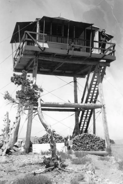
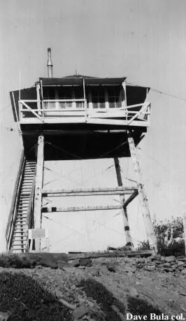
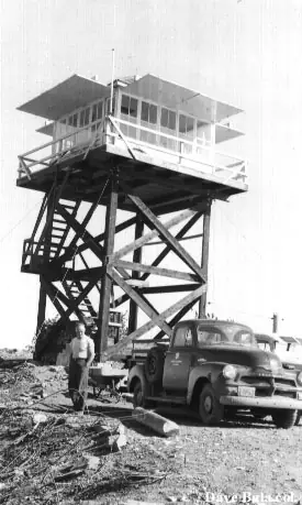
- 1954 Replaced by a new structureA 20-ft treated timber tower with an L-4 cab replaced the first structure.Sources: nhlr.org, oregonlookouts.weebly.com
- 1965 Replaced by a new structureLive-in R-6 cab on a 20-ft treated timber tower. NHLR says it came twelve years after 1954; firelookout.com says 1965.Sources: nhlr.org, firelookout.com
- 1971 RemovedPacific Northwest Bell unit removed in fall 1971; a later memo says it would not be reinstalled.Source: oregonlookouts.weebly.com
- 1980 EventNewspaper describes a combined tower and communications building built by private enterprise on leased Forest Service land, with a seasonal lookout planned.Source: oregonlookouts.weebly.com
- 1986 Built'Built' field on NHLR detail pageSource: NHLR register entry
- 1986 Replaced by a new structurePresent metal cab on a 20-ft metal tower, offered by a cable company that wanted a relay station; replaced the R-6 cab.Sources: nhlr.org, firelookout.com
- No record between 1986 and 2003
- 2003 Added to the National Historic Lookout RegisterRegistered March 31, 2003 as US 499, OR 92.Source: nhlr.org
- TodayStandingIt still stands, as far as our sources know.
Old maps of this spot
USGS topographic maps from the years a lookout stood may show it, often as a small symbol labelled “Lookout”. See the old topo maps around it on the Firefinder map, or find every scanned sheet of this spot on USGS TopoView (opens another site) (click the spot there to list them, with dates and downloads).
Story
Researched 8 Oct 2026, fact-checked.
Pelican Butte rises near Rocky Point in Klamath County, Oregon, about 27 miles northwest of Klamath Falls, in the Winema National Forest.1,2,3 Firelookout.com dates the first lookout here, a cable-braced pole L-4 tower, to 1935.3 A lookout history page quotes 1934 newspapers describing a 15-foot steel tower erected for panorama photos and a lookout station still under construction that summer, so the start date is not fully settled.2
In the late 1940s and early 1950s married couples staffed the lookout.2 A 1948 notice offered the post to a married couple with a car, and in 1949 a couple was to man the 14-by-14-foot station.2 In 1952 the road stayed drifted shut until mid-August, when the lookout shoveled through four-foot drifts to open it.2 A 1941 report says the Pelican Butte lookout felt an earth tremor.2
The first tower gave way to a timber L-4 cab in 1954.1,2 More than a decade later a live-in R-6 cab replaced it. The register says this came about twelve years after 1954, while firelookout.com dates it to 1965.1,3 In 1971 a Pacific Northwest Bell unit was removed, and a later memo says it would not be reinstalled.2 A 1980 newspaper piece described a combined tower and communications building, built by a private company on leased Forest Service land, with a lookout to be stationed there in season. The same page gives a 39-foot steel tower, which does not match the 20-foot height in later sources.1,2,3
The present metal cab dates to 1986.1,3 The register says a cable company wanted the summit as a relay station and offered the new cab as part of the deal.1 Firelookout.com says the 20-foot all-steel tower is now used only during emergencies.3
The register says the lookout is currently on standby.1 Cheryl Hill's list of standing Oregon lookouts shows it as unmanned, and as a site the public can legally reach. That does not mean the cab is open to visitors.4 The register also notes that members of the Forest Fire Lookout Association voted it Oregon's ugliest lookout, even though its history is colorful.1
None of the sources says whether the public may enter the cab or climb the tower. A 1967 survey description gives directions along a rough, bladed road to the tower, but no current road status turned up.2
- Pelican Butte Lookout, National Historic Lookout Register, http://nhlr.org/lookouts/us/or/pelican-butte-lookout/ (accessed 2026-10-08). ↩
- Pelican Butte, Forest Lookouts (Oregon Lookouts), https://oregonlookouts.weebly.com/pelican-butte.html (accessed 2026-10-08). ↩
- Pelican Butte Fire Lookout Tower, firelookout.com, https://www.firelookout.com/or/pelicanbutte.html (accessed 2026-10-08). ↩
- Oregon's Standing Lookouts, Every Lookout in Oregon (Cheryl Hill), https://cherylhill.net/firelookouts/oregons-standing-lookouts/ (accessed 2026-10-08). ↩
Photos
Photos keep their own rights and are shown with credit. Is one of these yours? You can ask for a different credit or for removal.
Sources
- National Historic Lookout Register (NHLR) (opens another site) Gave us: name, location, county, elevation, what it is built of, register numbers, agency, ownership, dates, photos, links National Historic Lookout Register (nhlr.org) · All rights reserved (American Resources, Inc.); facts extracted only, no prose copied. · retrieved 4 Oct 2026
- Forest Fire Lookout Association (FFLA) - US lookout lists (opens another site) Gave us: type, status, register numbers, links Forest Fire Lookout Association (firelookout.org) · No licence stated; facts extracted only, no prose copied. · retrieved 8 Oct 2026
- firelookout.com -- Rex Kamstra's Forest Fire Lookout Page (opens another site) Gave us: design, height, photos, links firelookout.com · No licence stated on the site; facts only (coordinates, elevation, built/destroyed years, design, agency). Photos mirrored with the site's stated credit. · retrieved 4 Oct 2026
- FOREST LOOKOUTS -- western US (Ron Kemnow's weebly sites) (opens another site) Gave us: links Ron Kemnow's Forest Lookouts sites (westlookouts, californialookouts, idaholookouts, montanalookouts, oregonlookouts and washingtonlookouts .weebly.com) · No licence stated; facts only (county, land manager, status word, coordinates where the page's own map widget gives them, township-range-section, height and design hints, links). The site's own newspaper quotes, citations and narrative are not reproduced. · retrieved 8 Oct 2026
- Every Lookout in Oregon (Cheryl Hill) (opens another site) Gave us: links Every Lookout in Oregon (Cheryl Hill, cherylhill.net) · No licence stated; facts only (name, agency, elevation, year built, design and height, status word, links). Posts' narrative and photos are not reproduced. · retrieved 8 Oct 2026
- Firefinder research Gave us: summary, design, height, status, agency, access, staffing, visiting details, dates, links, fact-check Firefinder research (sources cited in the story footnotes) · Our own research notes; each fact cites its source in the lookout's story
More about this lookout elsewhere
- NHLR register entry US 499 (nhlr.org) (opens another site)
- NHLR register entry (nhlr.org) (opens another site)
- FFLA Oregon lookout list (firelookout.org) (opens another site)
- Pelican Butte Lookout - Forest Lookouts Page (opens another site)
- Pelican Butte on firelookout.com (Rex Kamstra) (opens another site)
- Pelican Butte on Every Lookout in Oregon (Cheryl Hill) (opens another site)
Firefinder takes facts (places, dates, numbers) from these sources and writes its own words. See all sources and licences.