Fire lookout · Multnomah County, Oregon
Pepper Mountain Lookout Site
Multnomah County lookout: 10-foot L-4 tower built 1937, abandoned 1955; the summit is now a clearing reached by a 2.6-mile hike.
- Gone
- Restricted access
- Verified
Gone: The lookout no longer stands. Only the site is left. Abandoned in 1955; the register and firelookout.com say it is gone
Visit & stay
Gone: site only. The lookout no longer stands, so there is nothing to climb or rent.
Access
Restricted access
Access is seasonal, gated or needs a permit. Check before you go. Oregon Hikers describes a 2.6-mile hike to the summit from a roadside pullout on Brower Road, but says the route borders private land and asks hikers to respect private property
- Road to the top?
- Unknown
- Trail
- 2.6 miles with 700 ft of gain up an abandoned lookout road, from a pullout on Brower Road (Oregon Hikers)
Facts
- Status
- Type
- Cab on a tower10-foot wooden tower with an L-4 cabThe design: L-4
- Built of
- Wood
- Built
- 1937
- Height
- 10 ft (3.0 m)
- Elevation
- 2,137 ft (651 m)
- Agency
- Oregon Department of Forestry
- Land
- Federal land
- Location
- Multnomah County, Oregon
- Coordinates
- 45.52853, −122.17181
- Registers
- This entry
- VerifiedResearched, then checked independently. Updated 9 Oct 2026.
- Firefinder id
us-or-pepper-mountain
View from the cab
What the lookout saw from its cab: every ridge out to about 93 miles, the named peaks in sight, and other fire lookouts within view, worked out from terrain data in your browser.
This lookout is gone. The view is reconstructed from its recorded site and its recorded height.
Downloads about 3.6 MB of terrain data the first time.
Or see what it could see on the map: the ground in its line of sight.
History
Then and now
- 1936 StaffedApril 1936 newspaper item, quoted on Weebly, says a man was sent to keep watch from the Pepper Mountain lookout; a year before the register's build dateSource: oregonlookouts.weebly.com
- 1937 Built10-foot wooden L-4 towerSources: firetower.org, firelookout.com, oregonhikers.org
- 1942 EventAircraft Warning Service station activated November 14, 1942 (Weebly)Source: oregonlookouts.weebly.com
- 1943 EventAircraft Warning Service station Tare 1-9 inactivated June 5, 1943; Weebly says the Forest Service retained the site for fire detectionSource: oregonlookouts.weebly.com
- 1955 AbandonedAbandoned in 1955 and goneSources: firetower.org, firelookout.com, oregonlookouts.weebly.com
- 1955 Removed'Removed' field on FFLOS detail page: "abandoned 1955".Source: FFLOS register entry
- No record between 1955 and 2019
- 2019 Added to the Former Fire Lookout Sites RegisterRegistered September 18, 2019Source: firetower.org
- TodayGoneThe lookout no longer stands. Only the site is left.
Old maps of this spot
USGS topographic maps from the years a lookout stood may show it, often as a small symbol labelled “Lookout”. See the old topo maps around it on the Firefinder map, or find every scanned sheet of this spot on USGS TopoView (opens another site) (click the spot there to list them, with dates and downloads).
Story
Researched 9 Oct 2026, fact-checked.
Pepper Mountain, about 11 miles northeast of Sandy in Multnomah County, Oregon, got a small lookout in 1937.1,2 The register gives a wooden tower 10 feet high, fitted with an L-4 cab, and names the Oregon Department of Forestry as administrator.1
An April 24, 1936 item from The Bonneville Dam Chronicle, quoted on the Weebly page, names Bob Ellis as the man sent to staff the lookout that month, a year before the register's build date.3,1
Later, the Weebly page lists the site as an Aircraft Warning Service station, activated in November 1942 and inactivated in June 1943.3 It says the Forest Service kept the site for fire detection afterward. The register names the Oregon Department of Forestry without a date, so the sources do not agree on who administered the site after 1943.3,1
The register and firelookout.com both date the lookout's abandonment to 1955 and record it as gone.1,2
Oregon Hikers' field guide says the summit area offers no views, and that the trees ringing the clearing are about 70 years old.4 It also notes a few clumps of daffodils, which point to a lookout operator who enjoyed gardening.4
Oregon Hikers lists a 2.6-mile hike with 700 feet of gain up an abandoned lookout road, starting from a pullout on Brower Road. Its trailhead page warns that the route borders private land and asks hikers to treat neighboring property with respect.5
- Pepper Mountain Lookout Site, Former Fire Lookout Sites Register, http://firetower.org/lookouts/us/or/pepper-mountain-lookout-site/ (accessed 2026-10-09). ↩
- Pepper Mtn. Fire Lookout Tower, firelookout.com, https://www.firelookout.com/or/peppermtn.html (accessed 2026-10-09). ↩
- Pepper Mountain - Forest Lookouts, Oregon Lookouts, https://oregonlookouts.weebly.com/pepper-mountain.html (accessed 2026-10-09). ↩
- Pepper Mountain - Oregon Hikers Field Guide, Oregon Hikers, https://www.oregonhikers.org/field_guide/Pepper_Mountain (accessed 2026-10-09). ↩
- Pepper Mountain Trailhead - Oregon Hikers Field Guide, Oregon Hikers, https://www.oregonhikers.org/field_guide/Pepper_Mountain_Trailhead (accessed 2026-10-09). ↩
Photos
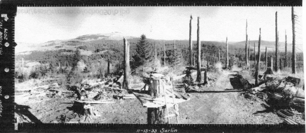
Photos keep their own rights and are shown with credit. Is one of these yours? You can ask for a different credit or for removal.
Sources
- Former Fire Lookout Sites Register (FFLOS) (opens another site) Gave us: name, location, county, elevation, what it is built of, register numbers, agency, dates, photos, links Former Fire Lookout Sites Register (firetower.org) · All rights reserved (American Resources, Inc.); facts extracted only, no prose copied. · retrieved 4 Oct 2026
- Forest Fire Lookout Association (FFLA) - US lookout lists (opens another site) Gave us: type, status, register numbers, links Forest Fire Lookout Association (firelookout.org) · No licence stated; facts extracted only, no prose copied. · retrieved 8 Oct 2026
- firelookout.com -- Rex Kamstra's Forest Fire Lookout Page (opens another site) Gave us: links firelookout.com · No licence stated on the site; facts only (coordinates, elevation, built/destroyed years, design, agency). Photos mirrored with the site's stated credit. · retrieved 4 Oct 2026
- FOREST LOOKOUTS -- western US (Ron Kemnow's weebly sites) (opens another site) Gave us: ownership, links Ron Kemnow's Forest Lookouts sites (westlookouts, californialookouts, idaholookouts, montanalookouts, oregonlookouts and washingtonlookouts .weebly.com) · No licence stated; facts only (county, land manager, status word, coordinates where the page's own map widget gives them, township-range-section, height and design hints, links). The site's own newspaper quotes, citations and narrative are not reproduced. · retrieved 8 Oct 2026
- Firefinder research Gave us: summary, design, height, status, agency, access, staffing, visiting details, dates, links, fact-check Firefinder research (sources cited in the story footnotes) · Our own research notes; each fact cites its source in the lookout's story
More about this lookout elsewhere
- FFLOS register entry US 1759 (firetower.org) (opens another site)
- Pepper Mountain - Oregon Hikers Field Guide (opens another site)
- Pepper Mountain Trailhead - Oregon Hikers Field Guide (opens another site)
- FFLA Oregon lookout list (firelookout.org) (opens another site)
- Pepper Mtn. on firelookout.com (Rex Kamstra) (opens another site)
- Pepper Mountain on Forest Lookouts, western US (Ron Kemnow) (opens another site)
Firefinder takes facts (places, dates, numbers) from these sources and writes its own words. See all sources and licences.