Fire lookout · Siskiyou County, Oregon
Quail Prairie Lookout
Also known as Quail Prairie Mountain
A 1963 R-6 flat-top built to replace a storm-destroyed neighbor, now storm-damaged itself and closed to rental reservations.
- Standing
- Rentable
- Restricted access
- Verified
Visit & stay
You can rent this lookout for overnight stays through recreation.gov.
Rules
- No water or electricity on site
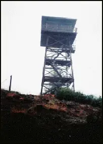
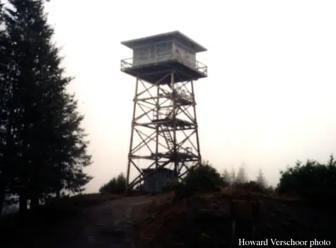
Overview THIS FACILITY IS CLOSED TO RESERVATIONS UNTIL FURTHER NOTICE Quail Prairie Lookout offers guests a unique lodging experience in the Rogue-Siskiyou National Forest in western Oregon. On a clear day, visitors are treated to spectacular views of the Kalmiopsis Wilderness from the top of the 41-foot tower. The tower was completed in 1963 and served as one of the last lookouts built by the southwestern Oregon Forest Service until the mid 1990's, when it was converted for recreational purposes. Today campers can enjoy a unique lodging experience in the historic structure, which offers basic amenities and spectacular views of the surrounding area. Although the facility provides basic amenities, guests must bring a few of their own supplies to ensure a safe and comfortable stay. Recreation The nearby Upper Chetco Trail is the main east/west route through the Kalmiopsis Wilderness. It offers access to the Chetco River and two main tributaries. Heavy vegetation provides shade but eliminates most views, and at least three significant long and steep sections provide a challenging backpacking experience. Anglers will enjoy the remote location and scenic backdrop of the nearby Chetco River, providing angling opportunities for trout, steelhead, and salmon in season. The Chetco starts in steep, deeply dissected, sparsely vegetated, mountainous terrain within the Kalmiopsis Wilderness. At night the lookout is an ideal setting for stargazing, as constellations and planets put on a dazzling display. Facilities The one-room lookout rests on the top of a 41-foot timber tower, surrounded by a catwalk. It is furnished with a single bed, a table and two chairs, a stool, broom and fire extinguisher. It also features a wood stove, a propane stove for cooking and a propane refrigerator. A vault toilet is located near the tower. There is no water or electricity available at the site. Guests must bring water for drinking, cooking and washing. In addition, visitors will need to supply a light source, sleeping bags, sleeping pads, cooking gear, towels, dish soap, matches, a first aid kit, toilet paper and garbage bags. Firewood is provided. Natural Features The lookout affords panoramic views of the Kalmiopsis Wilderness and the Chetco River drainage. The Kalmiopsis Wilderness is an area of great geological and botanical interest. Many of the rocks were formerly parts of the oceanic crust, while diverse plant life provides evidence of adaptation to the area's harsh soils. The Kalmiopsis leachian, a shrub discovered in the Gold Basin area in 1930, is a relic of the pre-ice age. The Kalmiopsis Wilderness is named after this unique endemic plant. Diverse landscapes provide habitat for a wide-range of wildlife, from spotted owls and black-tail deer to salamanders and salmon. These species, along with many others, depend on surrounding undeveloped wilderness, undisturbed wetlands, clean streams, and diverse forests to live.
Book on recreation.gov (opens recreation.gov)
Rental details from recreation.gov, checked 19 Oct 2026. Rules, fees and seasons change, so confirm on the booking page before you go. Data source: ridb.recreation.gov
Access
Restricted access
Access is seasonal, gated or needs a permit. Check before you go. Formerly a public Recreation.gov rental; currently closed to reservations until further notice due to storm damage.
- Can you climb it?
- No
- Road to the top?
- Yes, you can drive up
- Trail
- ~26 miles via North Bank Chetco River Rd / FS Road 1376 from Brookings; rough gravel road, hazardous cattle guard/pothole reported near mile 21.
- Staffing
- Unknown
Facts
- Status
- Type
- Cab on a towerR-6The design: R-6
- Built of
- Wood
- Built
- 1963
- Height
- 41 ft (12.5 m)
- Elevation
- 3,179 ft (969 m)
- Agency
- U.S. Forest Service
- Land
- Federal land
- Location
- Siskiyou County, Oregon
- Coordinates
- 42.24183, −124.04563 sources disagree
- Registers
- This entry
- VerifiedResearched, then checked independently. Updated 19 Oct 2026.
- Firefinder id
us-or-quail-prairie
View from the cab
What you see from the cab: every ridge out to about 93 miles, the named peaks in sight, and other fire lookouts within view, worked out from terrain data in your browser.
Downloads about 4.0 MB of terrain data the first time.
Or see what it could see on the map: the ground in its line of sight.
History
Then and now
- 1962 DestroyedNeighboring Long Ridge Lookout, which Quail Prairie replaced, was destroyed in the Columbus Day Storm of October 1962.Source: firelookout.com
- 1963 BuiltCurrent R-6 flat-top tower built to replace Long Ridge.Sources: nhlr.org, recreation.gov, firelookout.com
- No record between 1963 and 2002
- 2002 FireLookout was staffed and observed the Biscuit Fire burning for weeks nearby.Source: nhlr.org
- 2003 Added to the National Historic Lookout RegisterRegistered on the National Historic Lookout Register, March 2003 (per brief/register page).Source: nhlr.org
- No record between 2003 and 2026
- 2026 ClosedRecreation.gov listing currently shows the facility closed to reservations until further notice, attributed to storm damage per firelookout.com.Sources: recreation.gov, firelookout.com
- TodayStandingIt still stands, as far as our sources know.
Old maps of this spot
USGS topographic maps from the years a lookout stood may show it, often as a small symbol labelled “Lookout”. See the old topo maps around it on the Firefinder map, or find every scanned sheet of this spot on USGS TopoView (opens another site) (click the spot there to list them, with dates and downloads).
Story
Researched 4 Oct 2026, fact-checked.
Quail Prairie Lookout went up in 1963 to replace the nearby Long Ridge lookout, which the Columbus Day Storm destroyed the previous year.1 It was one of the last new lookout sites built in southwestern Oregon, and the structure itself follows the standard R-6 flat-top design: a live-in cab and catwalk set on a guyed, 41-foot treated-timber tower.2,3,1 It sits on what is now the Rogue River-Siskiyou National Forest, with views over the Kalmiopsis Wilderness and the Chetco River drainage.2,3
The tower stayed in active fire-watch service for decades. When the Biscuit Fire burned through the region for weeks in the summer of 2002, one of the largest fires in modern Oregon history, Quail Prairie had a front-row view of it.2 Sometime in the mid-1990s the Forest Service also began converting the lookout for recreational use; it was added to the National Historic Lookout Register later, in March 2003.2,3,1
For years afterward it carried a dual designation: Forest Service descriptions still list it as in active service for fire detection, and it also went out as an overnight rental through Recreation.gov, run by the Rogue River-Siskiyou National Forest — though NHLR volunteer visit reports from 2007 and 2015 found it unstaffed, and by 2015 described it as badly deteriorated.2,3 That arrangement has since broken down: the lookout was damaged by a storm within the past several years, and the Recreation.gov listing for it is now closed to reservations until further notice.3,1 Sources don't agree on exactly which storm or when, so the full story of the damage isn't settled.
Access, when the lookout is open, runs from Brookings along North Bank Chetco River Road, which becomes Forest Service Road 1376, for roughly 26 miles of mostly gravel driving.3 One visitor's account from an NHLR comment describes a rough stretch of that road near a cattle guard about 21 miles in, where a pothole caused a blown tire and a bent wheel rim, a reminder that the drive itself is part of the experience out here.2 For now, anyone hoping to stay overnight should check current status before planning a trip, since the facility is not currently taking reservations.3
- Quail Prairie Fire Lookout Tower, firelookout.com, https://www.firelookout.com/or/quailprairie.html (accessed 2026-10-04). ↩
- Quail Prairie Lookout, National Historic Lookout Register, http://nhlr.org/lookouts/us/or/quail-prairie-lookout/ (accessed 2026-10-04). ↩
- Quail Prairie Lookout, Rogue River-Siskiyou National Forest, Recreation.gov, https://www.recreation.gov/camping/campgrounds/234161 (accessed 2026-10-04). ↩
Photos
Photos keep their own rights and are shown with credit. Is one of these yours? You can ask for a different credit or for removal.
Where sources disagree
We show disagreements between sources instead of quietly picking one. If you know which is right, please tell us.
Sources disagree on the location by 580 m.
- NHLR: 42.24183, −124.04563
- recreation.gov: 42.23667, −124.04500
The map uses the position from NHLR.
Sources
- National Historic Lookout Register (NHLR) (opens another site) Gave us: name, location, county, elevation, what it is built of, register numbers, agency, dates, photos, links National Historic Lookout Register (nhlr.org) · All rights reserved (American Resources, Inc.); facts extracted only, no prose copied. · retrieved 4 Oct 2026
- Forest Fire Lookout Association (FFLA) - US lookout lists (opens another site) Gave us: type, status, register numbers, links Forest Fire Lookout Association (firelookout.org) · No licence stated; facts extracted only, no prose copied. · retrieved 8 Oct 2026
- Recreation Information Database (recreation.gov) (opens another site) Gave us: ownership, access, rental details, links Data source: ridb.recreation.gov · Public data from the US government · retrieved 19 Oct 2026
- firelookout.com -- Rex Kamstra's Forest Fire Lookout Page (opens another site) Gave us: design, photos, links firelookout.com · No licence stated on the site; facts only (coordinates, elevation, built/destroyed years, design, agency). Photos mirrored with the site's stated credit. · retrieved 4 Oct 2026
- FOREST LOOKOUTS -- western US (Ron Kemnow's weebly sites) (opens another site) Gave us: height, links Ron Kemnow's Forest Lookouts sites (westlookouts, californialookouts, idaholookouts, montanalookouts, oregonlookouts and washingtonlookouts .weebly.com) · No licence stated; facts only (county, land manager, status word, coordinates where the page's own map widget gives them, township-range-section, height and design hints, links). The site's own newspaper quotes, citations and narrative are not reproduced. · retrieved 8 Oct 2026
- Every Lookout in Oregon (Cheryl Hill) (opens another site) Gave us: register numbers, links Every Lookout in Oregon (Cheryl Hill, cherylhill.net) · No licence stated; facts only (name, agency, elevation, year built, design and height, status word, links). Posts' narrative and photos are not reproduced. · retrieved 8 Oct 2026
- Firefinder research Gave us: summary, design, height, status, agency, access, visiting details, dates, links, fact-check Firefinder research (sources cited in the story footnotes) · Our own research notes; each fact cites its source in the lookout's story
More about this lookout elsewhere
- NHLR register entry US 467 (nhlr.org) (opens another site)
- NHLR register entry (nhlr.org) (opens another site)
- Recreation.gov listing (opens another site)
- FFLA Oregon lookout list (firelookout.org) (opens another site)
- Quail Prairie on firelookout.com (Rex Kamstra) (opens another site)
- Quail Prairie Mountain on Forest Lookouts, western US (Ron Kemnow) (opens another site)
- Quail Prairie on Every Lookout in Oregon (Cheryl Hill) (opens another site)
Firefinder takes facts (places, dates, numbers) from these sources and writes its own words. See all sources and licences.