Lookout site, no structure · Marion County, Oregon
Rocky Top Lookout Site
- Gone
- No structure
- Access unknown
- Unverified
Unverified entry
This comes from a single source and nobody has checked it yet, so details may be wrong. If you know better, suggest an edit.
Gone: The lookout no longer stands. Only the site is left.
Visit & stay
Gone: site only. The lookout no longer stands, so there is nothing to climb or rent.
Access
Access unknown
We do not know the access rules. Check with the land manager before you go.
- Road to the top?
- Unknown
Facts
- Status
- Type
- Summit campSites with no structure: the observer watched from a summit and lived in a tent.L-4The design: L-4
- Built of
- Nothing was built
- Built
- Unknown
- Height
- Unknown
- Elevation
- 5,014 ft (1,528 m)
- Agency
- Oregon Department of Forestry
- Land
- Unknown
- Location
- Marion County, Oregon
- Coordinates
- 44.78839, −122.29246
- Registers
- This entry
- UnverifiedFrom a single source and not yet checked. Details may be wrong. Updated 8 Oct 2026.
- Firefinder id
us-or-rocky-top
View from the cab
What the lookout saw from its cab: every ridge out to about 93 miles, the named peaks in sight, and other fire lookouts within view, worked out from terrain data in your browser.
This lookout is gone. The view is reconstructed from its recorded site and a typical height for a lookout like it.
Downloads about 3.9 MB of terrain data the first time.
Or see what it could see on the map: the ground in its line of sight.
History
Then and now
- 2010 Added to the Former Fire Lookout Sites RegisterDate registered per FFLOS detail page: September 20, 2010Source: FFLOS register entry
- TodayGoneThe lookout no longer stands. Only the site is left. When it came down is not recorded.
Old maps of this spot
USGS topographic maps from the years a lookout stood may show it, often as a small symbol labelled “Lookout”. See the old topo maps around it on the Firefinder map, or find every scanned sheet of this spot on USGS TopoView (opens another site) (click the spot there to list them, with dates and downloads).
Story
Summary from our records, not yet researched.
Rocky Top Lookout Site was a summit fire lookout camp (L-4 design) in Marion County, Oregon, at 5,014 ft (1,528 m). It is recorded on the Former Fire Lookout Sites Register (US 644).
We have not researched this lookout's story yet. Know something about its history? Tell us.
Photos
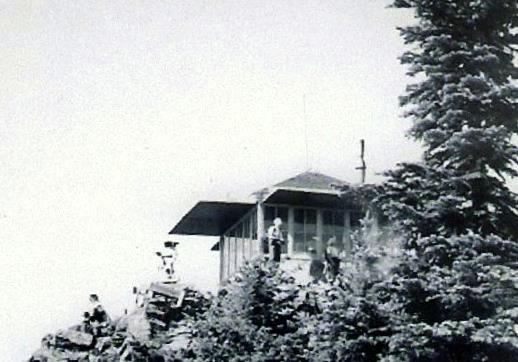
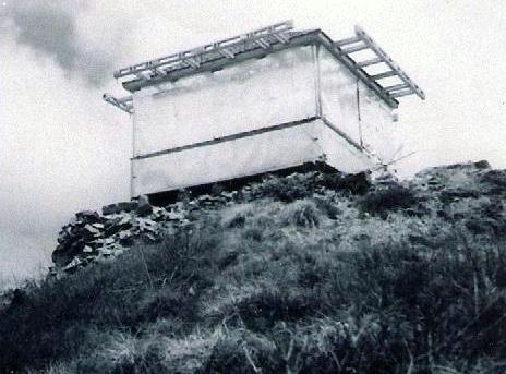
Photos keep their own rights and are shown with credit. Is one of these yours? You can ask for a different credit or for removal.
Sources
- Former Fire Lookout Sites Register (FFLOS) (opens another site) Gave us: name, location, county, elevation, register numbers, agency, dates, photos, links Former Fire Lookout Sites Register (firetower.org) · All rights reserved (American Resources, Inc.); facts extracted only, no prose copied. · retrieved 4 Oct 2026
- Forest Fire Lookout Association (FFLA) - US lookout lists (opens another site) Gave us: type, status, register numbers, links Forest Fire Lookout Association (firelookout.org) · No licence stated; facts extracted only, no prose copied. · retrieved 8 Oct 2026
- firelookout.com -- Rex Kamstra's Forest Fire Lookout Page (opens another site) Gave us: links firelookout.com · No licence stated on the site; facts only (coordinates, elevation, built/destroyed years, design, agency). Photos mirrored with the site's stated credit. · retrieved 4 Oct 2026
- FOREST LOOKOUTS -- western US (Ron Kemnow's weebly sites) (opens another site) Gave us: design, links Ron Kemnow's Forest Lookouts sites (westlookouts, californialookouts, idaholookouts, montanalookouts, oregonlookouts and washingtonlookouts .weebly.com) · No licence stated; facts only (county, land manager, status word, coordinates where the page's own map widget gives them, township-range-section, height and design hints, links). The site's own newspaper quotes, citations and narrative are not reproduced. · retrieved 8 Oct 2026
More about this lookout elsewhere
- FFLOS register entry US 644 (firetower.org) (opens another site)
- FFLA Oregon lookout list (firelookout.org) (opens another site)
- Rocky Top on firelookout.com (Rex Kamstra) (opens another site)
- Rocky Top on Forest Lookouts, western US (Ron Kemnow) (opens another site)
Firefinder takes facts (places, dates, numbers) from these sources and writes its own words. See all sources and licences.