Fire lookout · Coos County, Oregon
Signal Tree/Kenyon Mountain Lookout
Also known as Kenyon (Signal Tree)
Coos FPA lookout on Kenyon Mountain, OR: tree station, 1935 CCC tower, 1961 tower replaced by a camera; tower removed about 2011; present site not described.
- Gone
- Access unknown
- Verified
Gone: The lookout no longer stands. Only the site is left. Tower removed about 2011 (May 26, 2011 per Oregon Lookouts timeline). NHLR entry from 2003 still says in active service.
Visit & stay
Gone: site only. The lookout no longer stands, so there is nothing to climb or rent.
Access
Access unknown
We do not know the access rules. Check with the land manager before you go.
- Road to the top?
- Unknown
Facts
- Status
- sources disagree
- Type
- Cab on a towerLast tower: 53-ft treated wood with flat-roof live-in cab (ODF cab); earlier 100-ft timber tower with L-6 cab (1935)The design: L-6 sources disagree
- Built of
- Wood
- Built
- 1925
- Height
- 53 ft (16.2 m)
- Elevation
- 3,275 ft (998 m)
- Agency
- Coos Forest Protective Association (Coos FPA)
- Land
- Unknown
- Location
- Coos County, Oregon
- Coordinates
- 43.00187, −123.77905
- Registers
- This entry
- VerifiedResearched, then checked independently. Updated 9 Oct 2026.
- Firefinder id
us-or-signal-tree-kenyon-mountain
View from the cab
What the lookout saw from its cab: every ridge out to about 93 miles, the named peaks in sight, and other fire lookouts within view, worked out from terrain data in your browser.
This lookout is gone. The view is reconstructed from its recorded site and its recorded height.
Downloads about 3.6 MB of terrain data the first time.
Or see what it could see on the map: the ground in its line of sight.
History
Then and now
- 1924 First staffedLookout at Kenyon mountain reported a new fire (Morning Register, quoted on Oregon Lookouts page); earliest staffed reference in sources readSource: oregonlookouts.weebly.com
- 1925 BuiltCoos Bay Times lists Signal Tree as a new station near Camas Valley; NHLR dates the first cupola cabin only to the 1920sSources: nhlr.org, oregonlookouts.weebly.com
- 1930 StaffedGlade A. Sanford took the lookout post at Signal Tree, replacing J.F. Burkhart, whose school had started on September 2nd (Coos Bay Times, September 6, 1930)Source: oregonlookouts.weebly.com
- 1931 StaffedSubstitute to be provided after Carl Beeson was unable to take charge of the station through sicknessSource: oregonlookouts.weebly.com
- 1935 Replaced by a new structureCCC crew from Camp Bradford completed a 100-ft tower to replace the old tree and platform; NHLR gives 100-ft timber tower with L-6 cab, Oregon Lookouts timeline gives 110 ftSources: nhlr.org, firelookout.com, oregonlookouts.weebly.com
- No record between 1935 and 1959
- 1959 Replaced by a new structureCoos District annual report: 1935 tower demolished and replaced by a 50-ft CT-3 treated timber towerSource: oregonlookouts.weebly.com
- 1960 BuiltThe World, May 20, 1960 (quoted on Oregon Lookouts page): 50-ft tower being erected to replace the 110-ft tower; conflicts with the 1959 and 1961 datesSource: oregonlookouts.weebly.com
- 1961 BuiltPresent 53-ft treated wood tower with Oregon Department of Forestry flat-roof live-in cab (NHLR; firelookout.com says built 1961)Sources: nhlr.org, firelookout.com
- 1965 EventCoos District annual report: Elk Mountain serves as a replacement for Brewster Rock, Signal Tree and Blue Ridge lookoutsSource: oregonlookouts.weebly.com
- 1966 Altered6 x 8 ft cement block building for radio-repeater equipment completed at the Signal Tree lookout siteSource: oregonlookouts.weebly.com
- No record between 1966 and 2003
- 2003 Added to the National Historic Lookout RegisterRegistered March 1, 2003 as US 465, OR 62Source: nhlr.org
- 2011 RemovedTower removed May 26, 2011 (Oregon Lookouts timeline); firelookout.com says it came down about 2011Sources: firelookout.com, oregonlookouts.weebly.com
- TodayGoneThe lookout no longer stands. Only the site is left.
Old maps of this spot
USGS topographic maps from the years a lookout stood may show it, often as a small symbol labelled “Lookout”. See the old topo maps around it on the Firefinder map, or find every scanned sheet of this spot on USGS TopoView (opens another site) (click the spot there to list them, with dates and downloads).
Story
Researched 9 Oct 2026, fact-checked.
The Signal Tree station on Kenyon Mountain was in Coos County, Oregon, and the Coos Forest Protective Association administered it.1 A 1925 newspaper item called it a new station near Camas Valley.2
Its first lookout is described two ways. The Register calls it a cupola cabin from the 1920s.1 A lookout-history page describes a large red fir with pipes driven up its trunk as a spiral ladder to a viewing perch.2 A 1924 newspaper item on that page has a lookout on Kenyon Mountain reporting a new fire near Camas Valley.2
In 1935 a CCC crew from Camp Bradford finished a 100-foot tower, and the old tree and its platform were taken down.2 The Register also gives 1935 for a 100-foot timber tower fitted with an L-6 cab.1 Rainwater the pipes caught drained into the heart of the wood until the tree became dangerous and had to be removed.2 One timeline gives the 1935 tower as 110 feet, which the Register and firelookout.com do not.2,1,3
The papers named some of the people who staffed it. In September 1930 Glade A. Sanford took the lookout post, replacing J. F. Burkhart, whose school had started on September 2nd.2 In 1931 a substitute was to be provided after the assigned lookout fell ill.2
In 1959 a Coos district annual report says the 1935 tower was torn down and a 50-foot treated timber tower took its place.2 A May 1960 newspaper reports a 50-foot tower going up to replace one judged unsafe.2 The Register and firelookout.com date the present 53-foot tower to 1961, and it carried an Oregon Department of Forestry cab.1,3 The sources disagree on the year and the height, so the exact date stays open.1,3,2
A 1965 district report names Elk Mountain, about 3.5 miles southwest of Sitkum, as the successor to the Brewster Rock, Signal Tree and Blue Ridge lookouts.2 A 1966 entry records a cement-block building for radio-repeater equipment at the Signal Tree site.2 When the Register registered the tower in March 2003, it still described the tower as in active service.1
Firelookout.com says a detection camera replaced the tower in the 2000s, and that the tower came down about 2011.3 The Oregon Lookouts timeline gives the removal date as May 26, 2011.2
No source we read says what, if anything, still stands on the summit, or whether the public can reach it. The 1966 radio building and the detection camera are the last installations named, and no source says whether either survives.2,3 An undated account of the CCC work says a road built by the crews made the lookout reachable by car, but that may not describe the road today.2
- Signal Tree/Kenyon Mountain Lookout, National Historic Lookout Register, http://nhlr.org/lookouts/us/or/signal-treekenyon-mountain-lookout/ (accessed 2026-10-09). ↩
- Signal Tree - FOREST LOOKOUTS, Oregon Lookouts, https://oregonlookouts.weebly.com/signal-tree.html (accessed 2026-10-09). ↩
- Kenyon (Signal Tree) Fire Lookout Tower, firelookout.com, https://www.firelookout.com/or/kenyon.html (accessed 2026-10-09). ↩
Photos
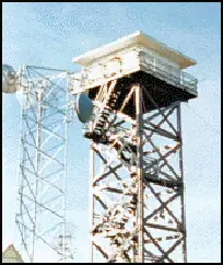
Photos keep their own rights and are shown with credit. Is one of these yours? You can ask for a different credit or for removal.
Where sources disagree
We show disagreements between sources instead of quietly picking one. If you know which is right, please tell us.
Sources disagree on whether it still stands.
- FFLA: Gone
- NHLR: Standing
- firelookout.com -- Rex Kamstra's Forest Fire Lookout Page: Gone
NHLR lists lookouts that were standing when registered. firelookout.com lists it, but not on its map of standing lookouts.
Sources disagree on what kind of structure it is.
- FFLA: Cab on a tower
- NHLR: Cab on a tower
- FOREST LOOKOUTS -- western US (Ron Kemnow's weebly sites): Lookout tree
Sources disagree on whether a tower or building stood here, or only a camp or lookout tree.
Sources
- National Historic Lookout Register (NHLR) (opens another site) Gave us: name, location, county, elevation, what it is built of, register numbers, agency, dates, photos, links National Historic Lookout Register (nhlr.org) · All rights reserved (American Resources, Inc.); facts extracted only, no prose copied. · retrieved 4 Oct 2026
- Forest Fire Lookout Association (FFLA) - US lookout lists (opens another site) Gave us: type, status, register numbers, links Forest Fire Lookout Association (firelookout.org) · No licence stated; facts extracted only, no prose copied. · retrieved 8 Oct 2026
- firelookout.com -- Rex Kamstra's Forest Fire Lookout Page (opens another site) Gave us: links firelookout.com · No licence stated on the site; facts only (coordinates, elevation, built/destroyed years, design, agency). Photos mirrored with the site's stated credit. · retrieved 4 Oct 2026
- FOREST LOOKOUTS -- western US (Ron Kemnow's weebly sites) (opens another site) Gave us: height, links Ron Kemnow's Forest Lookouts sites (westlookouts, californialookouts, idaholookouts, montanalookouts, oregonlookouts and washingtonlookouts .weebly.com) · No licence stated; facts only (county, land manager, status word, coordinates where the page's own map widget gives them, township-range-section, height and design hints, links). The site's own newspaper quotes, citations and narrative are not reproduced. · retrieved 8 Oct 2026
- Firefinder research Gave us: summary, design, height, status, agency, dates, links, fact-check Firefinder research (sources cited in the story footnotes) · Our own research notes; each fact cites its source in the lookout's story
More about this lookout elsewhere
- NHLR register entry US 465 (nhlr.org) (opens another site)
- FFLA Oregon lookout list (firelookout.org) (opens another site)
- Kenyon (Signal Tree) on firelookout.com (Rex Kamstra) (opens another site)
- Signal Tree (Kenyon Mountain) on Forest Lookouts, western US (Ron Kemnow) (opens another site)
Firefinder takes facts (places, dates, numbers) from these sources and writes its own words. See all sources and licences.