Fire lookout · Douglas County, Oregon
Skookum Prairie Lookout Site
Douglas County, OR L-5 cab dated 1933 in the Umpqua NF; removed or destroyed about 1958; no source describes the site today.
- Gone
- Access unknown
- Verified
Gone: The lookout no longer stands. Only the site is left. Cab removed (register) or destroyed (firelookout.com) about 1958; no source describes the site since
Visit & stay
Gone: site only. The lookout no longer stands, so there is nothing to climb or rent.
Access
Access unknown
We do not know the access rules. Check with the land manager before you go.
- Road to the top?
- Unknown
Facts
- Status
- Type
- Ground-level cabL-5 cabThe design: L-5
- Built of
- WoodGoing by its design; no source says so in words.
- Built
- 1933
- Height
- Unknown
- Elevation
- 5,855 ft (1,785 m)
- Agency
- U.S.Forest Service
- Land
- Federal land
- Location
- Douglas County, Oregon
- Coordinates
- 43.14037, −122.32872
- Registers
- This entry
- VerifiedResearched, then checked independently. Updated 9 Oct 2026.
- Firefinder id
us-or-skookum-prairie
View from the cab
What the lookout saw from its cab: every ridge out to about 93 miles, the named peaks in sight, and other fire lookouts within view, worked out from terrain data in your browser.
This lookout is gone. The view is reconstructed from its recorded site and a typical height for a lookout like it.
Downloads about 3.6 MB of terrain data the first time.
Or see what it could see on the map: the ground in its line of sight.
History
Then and now
- 1933 BuiltL-5 cab dated 1933 by the register and firelookout.comSources: firetower.org, firelookout.com
- 1933 EventPanorama photographs taken August 2, 1933; a September 1933 newspaper said the CCC would build a 10-by-10 lookout before snowSource: oregonlookouts.weebly.com
- No record between 1933 and 1958
- 1958 RemovedRegister says removed about 1958; firelookout.com says destroyed about 1958Sources: firetower.org, firelookout.com
- No record between 1958 and 2011
- 2011 Added to the Former Fire Lookout Sites RegisterRegistered March 29, 2011 as US 907, OR 274Source: firetower.org
- TodayGoneThe lookout no longer stands. Only the site is left.
Old maps of this spot
USGS topographic maps from the years a lookout stood may show it, often as a small symbol labelled “Lookout”. See the old topo maps around it on the Firefinder map, or find every scanned sheet of this spot on USGS TopoView (opens another site) (click the spot there to list them, with dates and downloads).
Story
Researched 9 Oct 2026, fact-checked.
The Skookum Prairie lookout was an L-5 cab on a southwest slope in the Umpqua National Forest, Douglas County, Oregon.1,2,3 It stood about two and a half miles west-southwest of the Garwood Lookout, at an elevation of 5,855 feet.1,2
The register and firelookout.com both date the cab to 1933.1,2 Panorama photographs were taken there on August 2, 1933.3 That September, a Roseburg newspaper reported that the CCC would build a 10-by-10 lookout before the snow flew, the standard size for a secondary lookout.3 A stream about a quarter mile east of the lookout served as its water source.3
The cab's end is described two ways. The register says it was removed about 1958, while firelookout.com says it was destroyed about that time.1,2 The sources differ on how it ended, but both place the end around 1958.1,2
The Former Fire Lookout Sites register lists the site as US 907, OR 274, and registered it on March 29, 2011.1
No source we read describes what, if anything, remains at the site now, or whether the land is open to visitors.
- Skookum Prairie Lookout Site, Former Fire Lookout Sites register, http://firetower.org/lookouts/us/or/skookum-prairie-lookout-site/ (accessed 2026-10-09). ↩
- Skookum Prairie Fire Lookout Cabin, firelookout.com, https://www.firelookout.com/or/skookumprairie.html (accessed 2026-10-09). ↩
- Skookum Prairie - Forest Lookouts, Forest Lookouts (Oregon), https://oregonlookouts.weebly.com/skookum-prairie.html (accessed 2026-10-09). ↩
Photos
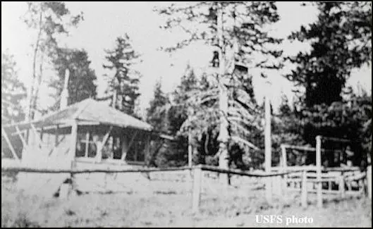
Photos keep their own rights and are shown with credit. Is one of these yours? You can ask for a different credit or for removal.
Sources
- Former Fire Lookout Sites Register (FFLOS) (opens another site) Gave us: name, location, county, elevation, what it is built of, register numbers, agency, ownership, dates, photos, links Former Fire Lookout Sites Register (firetower.org) · All rights reserved (American Resources, Inc.); facts extracted only, no prose copied. · retrieved 4 Oct 2026
- Forest Fire Lookout Association (FFLA) - US lookout lists (opens another site) Gave us: type, status, register numbers, links Forest Fire Lookout Association (firelookout.org) · No licence stated; facts extracted only, no prose copied. · retrieved 8 Oct 2026
- firelookout.com -- Rex Kamstra's Forest Fire Lookout Page (opens another site) Gave us: links firelookout.com · No licence stated on the site; facts only (coordinates, elevation, built/destroyed years, design, agency). Photos mirrored with the site's stated credit. · retrieved 4 Oct 2026
- FOREST LOOKOUTS -- western US (Ron Kemnow's weebly sites) (opens another site) Gave us: links Ron Kemnow's Forest Lookouts sites (westlookouts, californialookouts, idaholookouts, montanalookouts, oregonlookouts and washingtonlookouts .weebly.com) · No licence stated; facts only (county, land manager, status word, coordinates where the page's own map widget gives them, township-range-section, height and design hints, links). The site's own newspaper quotes, citations and narrative are not reproduced. · retrieved 8 Oct 2026
- Firefinder research Gave us: summary, design, status, agency, dates, links, fact-check Firefinder research (sources cited in the story footnotes) · Our own research notes; each fact cites its source in the lookout's story
More about this lookout elsewhere
- FFLOS register entry US 907 (firetower.org) (opens another site)
- FFLA Oregon lookout list (firelookout.org) (opens another site)
- Skookum Prairie on firelookout.com (Rex Kamstra) (opens another site)
- Skookum Prairie on Forest Lookouts, western US (Ron Kemnow) (opens another site)
Firefinder takes facts (places, dates, numbers) from these sources and writes its own words. See all sources and licences.