Fire lookout · Jackson County, Oregon
Soda Mountain Lookout
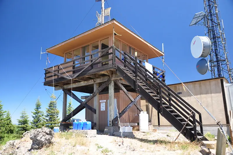
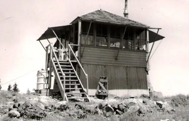
A 1933 CCC-built L-4 cab, replaced in 1962 by an ODF cab on a 10-ft tower; staffed through 2017, found closed in 2023, on BLM land beside the PCT.
- Standing
- Closed
- Verified
Closed
The site is closed to visitors. Cab closed up with a camera for remote monitoring as of May 2023; no source describes the cab as open to visitors. The site is BLM land inside the Cascade-Siskiyou National Monument, reached on foot from the Pacific Crest Trail.
Visit & stay
Not rentable. As far as we know, this lookout cannot be booked for overnight stays.
Access
Closed. See the warning at the top of this page.
- Can you climb it?
- Unknown
- Road to the top?
- Unknown
- Trail
- From the Hobart Bluff trailhead, about a mile south on the Pacific Crest Trail, then a cutoff and a rough dirt road just under a mile to the summit (2017 visit account).
- Staffing
- Not staffed (as of 2023)
Facts
- Status
- Type
- Cab on a towerODF 14 x 14 ft flat-roof cab on a 10 ft wooden tower (1962); original 1933 L-4 cab on a 6 ft baseThe design: L-4
- Built of
- Wood
- Built
- 1933
- Height
- 10 ft (3.0 m)
- Elevation
- 6,049 ft (1,844 m)
- Agency
- Oregon Department of Forestry
- Land
- Unknown
- Location
- Jackson County, Oregon
- Coordinates
- 42.06448, −122.47883
- Registers
- This entry
- VerifiedResearched, then checked independently. Updated 8 Oct 2026.
- Firefinder id
us-or-soda-mountain
View from the cab
What you see from the cab: every ridge out to about 93 miles, the named peaks in sight, and other fire lookouts within view, worked out from terrain data in your browser.
Downloads about 3.6 MB of terrain data the first time.
Or see what it could see on the map: the ground in its line of sight.
History
Then and now
- 1933 BuiltFirst lookout: an L-4 cab on a 6 ft base, completed by a CCC crewSources: nhlr.org, oregonlookouts.weebly.com
- 1934 First staffedIra Tungate acted as lookout in the summer before a January 1935 notice; earliest named lookout in these sourcesSource: oregonlookouts.weebly.com
- No record between 1934 and 1952
- 1952 StaffedThelma Sims stationed on the summit; a 1955 account counts her sixth or seventh year on the mountainSource: oregonlookouts.weebly.com
- 1955 EventLightning struck the lookout station in August; the only damage reported was to the telephone systemSource: oregonlookouts.weebly.com
- 1962 BuiltSource: firelookout.com -- Rex Kamstra's Forest Fire Lookout Page
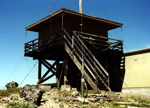
- 1962 Replaced by a new structureODF replaced the 1933 cab with the present 14 x 14 ft flat-roof cab on a 10 ft tower; 1961 cabin raise and 1962 new tower per the Forest Lookouts historySources: nhlr.org, firelookout.com, oregonlookouts.weebly.com
- 1968 AlteredA communications site was built on the summit and the lookout was electrifiedSource: oregonlookouts.weebly.com
- No record between 1968 and 1992
- 1992 AlteredCellular One installed a tower and equipment building beside the cab; the view from the lookout was blockedSource: oregonlookouts.weebly.com
- 1993 AlteredCab raised four feet, which the history gives as a 9 ft 10 in tower with a new stair configurationSource: oregonlookouts.weebly.com
- 2000 Added to the National Historic Lookout RegisterRegistered on the National Historic Lookout Register June 15, 2000Source: nhlr.org
- No record between 2000 and 2017
- 2017 Last staffedStaffed every summer through 2017; a July 2, 2017 visit found it staffedSources: firelookout.com, cherylhill.net
- 2023 ClosedFound closed up with a remote-monitoring camera on a May 2023 visit; BLM said it was no longer staffed. The closure date is not given in the sourcesSources: cherylhill.net, cherylhill.net
- TodayStandingIt still stands, as far as our sources know.
Old maps of this spot
USGS topographic maps from the years a lookout stood may show it, often as a small symbol labelled “Lookout”. See the old topo maps around it on the Firefinder map, or find every scanned sheet of this spot on USGS TopoView (opens another site) (click the spot there to list them, with dates and downloads).
Story
Researched 8 Oct 2026, fact-checked.
Soda Mountain Lookout stands on the Siskiyou Range in southern Oregon, four miles north of the California border and about 13 miles southeast of Ashland.1,2 A crew of Civilian Conservation Corps workers finished the first cabin in 1933, an L-4 cab on a short tower.1,3 A 1934 field report said Soda Mountain would cover the east side of Jenny Creek, the part of the mountain that was otherwise out of view.3
In 1961 and 1962 crews raised the cabin and built a new tower.3 The present cab, a 14-by-14-foot flat-roofed Oregon Department of Forestry cab on a 10-foot wooden tower, dates from 1962.1,2 The sources disagree on the height: a 1993 entry says a four-foot raise produced a 9-foot-10-inch tower.3
The Oregon Department of Forestry operated the lookout, according to BLM staff who spoke with a 2023 visitor.4 A January 1935 notice named Ira Tungate as the lookout the previous summer, and by 1952 Thelma Sims was stationed on the summit.3 In August 1955 lightning struck the station and knocked out its telephone system, the only damage reported.3 The same account noted that Sims was in her sixth or seventh year on the mountain.3
Communications gear came to the summit in 1968.3 In 1992 Cellular One, a telephone company, installed a tower and equipment building beside the cab, and the view from the lookout was blocked.3
Firelookout.com says the cab was staffed every summer through 2017, and a visitor found it staffed in July 2017.2,5 A May 2023 visit found the cab closed up with a camera for remote monitoring, and BLM staff confirmed it was no longer staffed.5,4 The National Historic Lookout Register entry still describes the lookout as active, which the 2023 visit does not support.1,4
The site is BLM land inside the Cascade-Siskiyou National Monument, near the Pacific Crest Trail.1 The lookout was registered on the National Historic Lookout Register on June 15, 2000.1
Reaching the summit takes a hike. A 2017 visitor parked at the Hobart Bluff trailhead, walked south on the Pacific Crest Trail for about a mile, then took a cutoff and a rough dirt road just under a mile to the top.5 Sources describe the cab as closed and the summit as crowded with communications equipment, so the cab should be treated as off limits rather than a place to climb.4
- Soda Mountain Lookout, National Historic Lookout Register, http://nhlr.org/lookouts/us/or/soda-mountain-lookout/ (accessed 2026-10-08). ↩
- Soda Mtn. Fire Lookout Tower, firelookout.com, https://www.firelookout.com/or/sodamtn.html (accessed 2026-10-08). ↩
- Soda Mountain, Forest Lookouts (oregonlookouts.weebly.com), https://oregonlookouts.weebly.com/soda-mountain.html (accessed 2026-10-08). ↩
- Return to Soda Mountain, Every Lookout in Oregon, https://cherylhill.net/firelookouts/2023/06/29/return-to-soda-mountain/ (accessed 2026-10-08). ↩
- Soda Mountain, Every Lookout in Oregon, https://cherylhill.net/firelookouts/2017/07/03/soda-mountain/ (accessed 2026-10-08). ↩
Photos
Photos keep their own rights and are shown with credit. Is one of these yours? You can ask for a different credit or for removal.
Sources
- National Historic Lookout Register (NHLR) (opens another site) Gave us: name, location, county, elevation, register numbers, agency, dates, photos, links National Historic Lookout Register (nhlr.org) · All rights reserved (American Resources, Inc.); facts extracted only, no prose copied. · retrieved 4 Oct 2026
- Forest Fire Lookout Association (FFLA) - US lookout lists (opens another site) Gave us: type, status, register numbers, links Forest Fire Lookout Association (firelookout.org) · No licence stated; facts extracted only, no prose copied. · retrieved 8 Oct 2026
- firelookout.com -- Rex Kamstra's Forest Fire Lookout Page (opens another site) Gave us: what it is built of, design, height, staffing, dates, photos, links firelookout.com · No licence stated on the site; facts only (coordinates, elevation, built/destroyed years, design, agency). Photos mirrored with the site's stated credit. · retrieved 4 Oct 2026
- OpenStreetMap -- fire lookout structures (opens another site) Gave us: links © OpenStreetMap contributors · ODbL 1.0. (c) OpenStreetMap contributors. · retrieved 4 Oct 2026
- FOREST LOOKOUTS -- western US (Ron Kemnow's weebly sites) (opens another site) Ron Kemnow's Forest Lookouts sites (westlookouts, californialookouts, idaholookouts, montanalookouts, oregonlookouts and washingtonlookouts .weebly.com) · No licence stated; facts only (county, land manager, status word, coordinates where the page's own map widget gives them, township-range-section, height and design hints, links). The site's own newspaper quotes, citations and narrative are not reproduced. · retrieved 8 Oct 2026
- Every Lookout in Oregon (Cheryl Hill) (opens another site) Gave us: links Every Lookout in Oregon (Cheryl Hill, cherylhill.net) · No licence stated; facts only (name, agency, elevation, year built, design and height, status word, links). Posts' narrative and photos are not reproduced. · retrieved 8 Oct 2026
- Firefinder research Gave us: summary, design, height, status, agency, access, staffing, visiting details, dates, links, fact-check Firefinder research (sources cited in the story footnotes) · Our own research notes; each fact cites its source in the lookout's story
More about this lookout elsewhere
- NHLR register entry US 340 (nhlr.org) (opens another site)
- Return to Soda Mountain (Every Lookout in Oregon) (opens another site)
- FFLA Oregon lookout list (firelookout.org) (opens another site)
- Soda Mountain Lookout - Forest Lookouts Page (opens another site)
- Soda Mtn. on firelookout.com (Rex Kamstra) (opens another site)
- Soda Mountain on Every Lookout in Oregon (Cheryl Hill) (opens another site)
- OpenStreetMap way 989246267 (opens another site)
Firefinder takes facts (places, dates, numbers) from these sources and writes its own words. See all sources and licences.