Fire lookout · Wheeler County, Oregon
Spanish Peak Lookout Site
Ochoco NF summit lookout in Wheeler County: cab 1923, timber tower 1938, removed 1968; concrete footings remain and forest roads reach the summit.
- Gone
- Open to the public
- Verified
Gone: The lookout no longer stands. Only the site is left. Tower removed in 1968 (register) or destroyed that year (firelookout.com); concrete footings remain on the summit per Oregon Hikers
Visit & stay
Gone: site only. The lookout no longer stands, so there is nothing to climb or rent. You may still be able to visit the site.
Access
Open to the public. Reached by National Forest roads; Outdoor Pilgrim describes a dirt road with no signs on the route and possible closures of some land access from December 1 to May 1 for bald eagles
- Road to the top?
- Yes, you can drive up
- Trail
- Outdoor Pilgrim says the Rim Trailhead on NF-200, about 1.5 miles from the summit, is the most common place for hikers to park
Facts
- Status
- Type
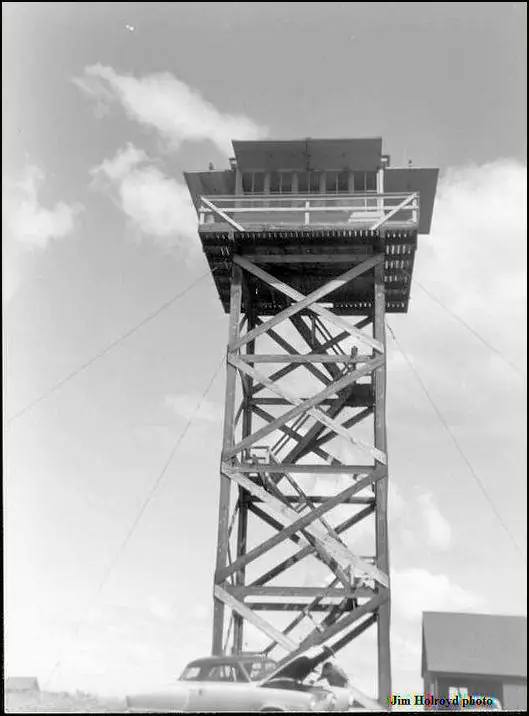
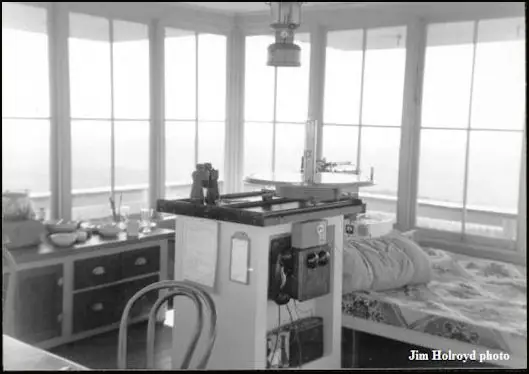
- Cab on a tower14x14 ft cab on a treated timber L-4 tower (per register and firelookout.com)The design: L-4
- Built of
- Wood
- Built
- 1923
- Height
- 50 ft (15.2 m)
- Elevation
- 6,871 ft (2,094 m)
- Agency
- U.S. Forest Service, Ochoco National Forest
- Land
- Federal land
- Location
- Wheeler County, Oregon
- Coordinates
- 44.40728, −119.77507
- Registers
- This entry
- VerifiedResearched, then checked independently. Updated 9 Oct 2026.
- Firefinder id
us-or-spanish-peak
View from the cab
What the lookout saw from its cab: every ridge out to about 93 miles, the named peaks in sight, and other fire lookouts within view, worked out from terrain data in your browser.
This lookout is gone. The view is reconstructed from its recorded site and its recorded height.
Downloads about 3.9 MB of terrain data the first time.
Or see what it could see on the map: the ground in its line of sight.
History
Then and now
- 1921 EventSummit first used as a campSources: firelookout.com, oregonhikers.org
- 1923 Built14x14 ft cab built on the summit; a 1923 newspaper item and firelookout.com give 1923 (register says 1930)Sources: firelookout.com, oregonlookouts.weebly.com, oregonhikers.org
- 1924 StaffedMartin Statey occupies the new lookout house as primary lookoutSource: oregonlookouts.weebly.com
- 1927 StaffedFloyd Jones reporting fires from the lookoutSource: oregonlookouts.weebly.com
- 1930 BuiltRegister gives 1930 for the 14x14 ft cab; this conflicts with the 1923 sourcesSource: firetower.org
- 1930 FireLookout Marvin Angle reports a timber fire about two miles southwest of Derr stationSource: oregonlookouts.weebly.com
- 1931 AlteredCab raised onto 20-foot stilts for better visibilitySources: firelookout.com, oregonlookouts.weebly.com
- 1934 FireFour-acre man-caused fire on Cottonwood Creek near Dayville, reported by the Spanish Peak lookoutSource: oregonlookouts.weebly.com
- 1934 EventForest radio station working on the peak, in daily contact with Tamarack Mountain and Fields PeakSource: oregonlookouts.weebly.com
- 1938 Replaced by a new structureTimber tower built to replace the old one; register says 50 ft L-4 and dates the replacement to 1939, a 1938 newspaper item says 40 ftSources: firetower.org, firelookout.com, oregonlookouts.weebly.com
- 1952 StaffedEudora and Leora Houston posted as Spanish Peak lookouts; last staffing found in sourcesSources: firelookout.com, oregonlookouts.weebly.com
- No record between 1952 and 1968
- 1968 RemovedTower removed (register and Oregon Hikers); firelookout.com says destroyedSources: firetower.org, firelookout.com, oregonhikers.org
- No record between 1968 and 2011
- 2011 Added to the Former Fire Lookout Sites RegisterDate registered per FFLOS detail page: July 16, 2011Source: FFLOS register entry
- TodayGoneThe lookout no longer stands. Only the site is left.
Old maps of this spot
USGS topographic maps from the years a lookout stood may show it, often as a small symbol labelled “Lookout”. See the old topo maps around it on the Firefinder map, or find every scanned sheet of this spot on USGS TopoView (opens another site) (click the spot there to list them, with dates and downloads).
Story
Researched 9 Oct 2026, fact-checked.
Spanish Peak rises to about 6,871 feet in the Ochoco National Forest, in Wheeler County.1,2,3 The summit was once called Bald Mountain.4 A camp went up on top in 1921, and a 14-by-14-foot cab followed in 1923.2,5
A May 1923 newspaper item said the planned house would be the first standard lookout house on the Ochoco forest.4 The lookout register gives 1930 for the cab instead, so the dates disagree.1 In December 1931 the lookout house was raised onto 20-foot stilts late in the fire season, for better visibility.4
The old house gave way to a timber tower in 1938.2,5 The sources disagree about its size. A 1938 newspaper item described a 40-foot tower, while the register and firelookout.com give 50 feet.4,1,2 The register also dates the swap to 1939.1
Martin Statey moved into the new house in 1924, and Floyd Jones was reporting fires from it by 1927.4 In August 1930, lookout Marvin Angle reported a timber fire about two miles southwest of Derr station.4 An August 1934 newspaper item said a forest radio station on the peak kept daily contact with Tamarack Mountain, on the Umatilla forest, and Fields Peak, on the Malheur.4 The last staffing we found is from 1952, when sisters Eudora and Leora Houston were posted there.2,4
The register says the tower was removed in 1968.1 Firelookout.com says it was destroyed that year.2 Oregon Hikers links its removal to a drop in the use of lookouts.5
We found no source that describes a standing structure today. Oregon Hikers reports that concrete footings can still be seen on the summit, and that a rough, unmaintained road runs to the top.5 Outdoor Pilgrim says a visitor with a moderately high clearance vehicle can drive to the summit on National Forest roads.3 The Forest Service may close some land access from December 1 to May 1 because of bald eagles.3
- Spanish Peak Lookout Site, Former Fire Lookout Sites register, http://firetower.org/lookouts/us/or/spanish-peak-lookout-site/ (accessed 2026-10-09). ↩
- Spanish Peak Fire Lookout Tower, firelookout.com, https://www.firelookout.com/or/spanishpeak.html (accessed 2026-10-09). ↩
- Spanish Peak, Outdoor Pilgrim, https://outdoorpilgrim.com/oregon-cohp-spanish-peak/ (accessed 2026-10-09). ↩
- Spanish Peak, Forest Lookouts (historic newspaper excerpts), Oregon Lookouts, https://oregonlookouts.weebly.com/spanish-peak.html (accessed 2026-10-09). ↩
- Spanish Peak, Oregon Hikers field guide, https://www.oregonhikers.org/field_guide/Spanish_Peak (accessed 2026-10-09). ↩
Photos
Photos keep their own rights and are shown with credit. Is one of these yours? You can ask for a different credit or for removal.
Sources
- Former Fire Lookout Sites Register (FFLOS) (opens another site) Gave us: name, location, county, elevation, what it is built of, register numbers, agency, ownership, dates, photos, links Former Fire Lookout Sites Register (firetower.org) · All rights reserved (American Resources, Inc.); facts extracted only, no prose copied. · retrieved 4 Oct 2026
- Forest Fire Lookout Association (FFLA) - US lookout lists (opens another site) Gave us: type, status, register numbers, links Forest Fire Lookout Association (firelookout.org) · No licence stated; facts extracted only, no prose copied. · retrieved 8 Oct 2026
- firelookout.com -- Rex Kamstra's Forest Fire Lookout Page (opens another site) Gave us: links firelookout.com · No licence stated on the site; facts only (coordinates, elevation, built/destroyed years, design, agency). Photos mirrored with the site's stated credit. · retrieved 4 Oct 2026
- FOREST LOOKOUTS -- western US (Ron Kemnow's weebly sites) (opens another site) Gave us: height, links Ron Kemnow's Forest Lookouts sites (westlookouts, californialookouts, idaholookouts, montanalookouts, oregonlookouts and washingtonlookouts .weebly.com) · No licence stated; facts only (county, land manager, status word, coordinates where the page's own map widget gives them, township-range-section, height and design hints, links). The site's own newspaper quotes, citations and narrative are not reproduced. · retrieved 8 Oct 2026
- Firefinder research Gave us: summary, design, height, status, agency, access, visiting details, dates, links, fact-check Firefinder research (sources cited in the story footnotes) · Our own research notes; each fact cites its source in the lookout's story
More about this lookout elsewhere
- FFLOS register entry US 1092 (firetower.org) (opens another site)
- Spanish Peak (Oregon Hikers field guide) (opens another site)
- Spanish Peak - Wheeler Co. High Point (Outdoor Pilgrim) (opens another site)
- FFLA Oregon lookout list (firelookout.org) (opens another site)
- Spanish Peak on firelookout.com (Rex Kamstra) (opens another site)
- Spanish Peak on Forest Lookouts, western US (Ron Kemnow) (opens another site)
Firefinder takes facts (places, dates, numbers) from these sources and writes its own words. See all sources and licences.