Fire lookout · Jackson County, Oregon
Wagner Butte Lookout Site
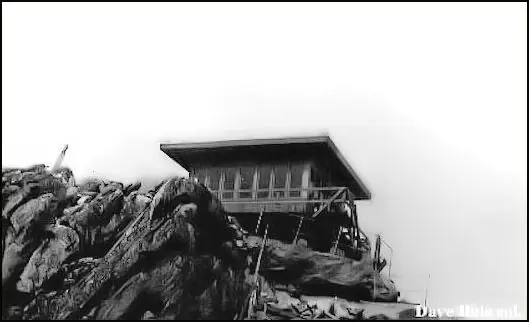
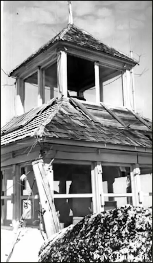
Jackson County lookout on Wagner Butte: tent camp 1913 or rag camp 1915, cupola cabin 1923, R-6 cab 1961, burned or removed 1971. Foundations and a railing remain.
- Gone
- Open to the public
- Verified
Gone: The lookout no longer stands. Only the site is left. Cab removed or burned in 1971; the foundations and a metal railing remain
Visit & stay
Gone: site only. The lookout no longer stands, so there is nothing to climb or rent. You may still be able to visit the site.
Access
Open to the public. National Forest trail; the trail page advises against stock because crossing a landslide area is difficult
- Road to the top?
- Unknown
- Trail
- Trail #1011 begins on Forest Road 22; the last stretch is a short scramble over large boulders
Facts
- Status
- Type
- Ground-level cabD-6 cupola cabin (1923), then a prefabricated R-6 flat cab (1961)The designs: R-6, D-6
- Built of
- Not recorded
- Built
- 1923
- Height
- 15 ft (4.6 m)
- Elevation
- 7,140 ft (2,176 m)
- Agency
- U.S. Forest Service, Crater then Rogue River National Forest
- Land
- Federal land
- Location
- Jackson County, Oregon
- Coordinates
- 42.12765, −122.77258
- Registers
- This entry
- VerifiedResearched, then checked independently. Updated 9 Oct 2026.
- Firefinder id
us-or-wagner-butte
View from the cab
What the lookout saw from its cab: every ridge out to about 93 miles, the named peaks in sight, and other fire lookouts within view, worked out from terrain data in your browser.
This lookout is gone. The view is reconstructed from its recorded site and its recorded height.
Downloads about 3.6 MB of terrain data the first time.
Or see what it could see on the map: the ground in its line of sight.
History
Then and now
- 1913 EventTent camp and Osborne alidade established, per Oregon Hikers and Forest Lookouts; the register dates a rag camp to 1915Sources: oregonhikers.org, oregonlookouts.weebly.com, firetower.org
- 1916 EventOsborne fire-finder on the summit; the observer had to climb down the rocks to the telephone to report a fireSource: oregonlookouts.weebly.com
- 1920 StaffedObserver on the summit for the Forest ServiceSource: oregonlookouts.weebly.com
- 1923 BuiltSummit leveled with explosives; D-6 cupola cabin, the first permanent structure, finished in OctoberSources: firetower.org, firelookout.com, oregonlookouts.weebly.com
- 1934 FireLightning struck the station and ignited a box of matches; no damage reportedSource: oregonlookouts.weebly.com
- 1938 FireFire reported from the lookout and completely out by 9 p.m. that daySource: oregonlookouts.weebly.com
- 1941 FireLightning struck 500 yards from the lookout stationSource: oregonlookouts.weebly.com
- No record between 1941 and 1961
- 1961 Replaced by a new structureOld cabin dismantled; prefabricated R-6 flat cab about 15 feet square built, concrete flown in by helicopterSources: firetower.org, oregonlookouts.weebly.com
- 1964 EventForest Lookouts history lists the lookout as discontinuedSource: oregonlookouts.weebly.com
- 1971 BurnedIntentionally burned by smokejumpers, per Oregon Hikers; the register says removed and firelookout.com says destroyedSources: oregonhikers.org, firetower.org, firelookout.com
- No record between 1971 and 2011
- 2011 Added to the Former Fire Lookout Sites RegisterDate registered per FFLOS detail page: April 21, 2011Source: FFLOS register entry
- TodayGoneThe lookout no longer stands. Only the site is left.
Old maps of this spot
USGS topographic maps from the years a lookout stood may show it, often as a small symbol labelled “Lookout”. See the old topo maps around it on the Firefinder map, or find every scanned sheet of this spot on USGS TopoView (opens another site) (click the spot there to list them, with dates and downloads).
Story
Researched 9 Oct 2026, fact-checked.
Observers have watched for fire from Wagner Butte since the 1910s, but the sources do not agree on the start date.1,2 The Oregon Hikers page dates a tent camp and an Osborne alidade there to 1913.1,3 The register dates a rag camp to 1915.2 By 1916 an Osborne fire-finder sat on the summit, so an observer had to go down over the rocks to reach the telephone, which a forest report called awkward.3
Crews leveled the summit with explosives in 1923 to make room for a cabin.3,1 Ranger Port and J.J. Deadmond went up on October 23 to complete the building.3 According to the register, it was the site's first permanent structure, a D-6 cupola cabin finished that year.2
Observers worked the cabin through the 1920s and 1930s, and local papers recorded some of their work.3 In 1934 lightning struck the station and set a box of matches alight, causing no damage.3 In 1938 an observer reported a fire from the summit, and a crew had it fully out by 9 p.m.3 In 1941 lightning struck 500 yards from the station.3
In 1961 the old cabin was dismantled and a prefabricated cab, about 15 feet square, took its place.3,2 Concrete went up by helicopter, and that summer's observer, a junior at Stanford, lived in a tent from late June.3
The 1961 cab came down a decade later.2 The register says it was removed in 1971.2 firelookout.com says it was destroyed that year.4 Oregon Hikers says smokejumpers deliberately burned it in 1971, once spotting from aircraft had become the more efficient method.1 A Forest Service trail page dates the removal to the 1970s and gives the same reason.5 The Forest Lookouts history lists the lookout as discontinued in 1964, but no source says when staffing ended.3
Today the summit holds a few reminders. Oregon Hikers reports that the foundations and a metal railing still stand, and a faded sign recounts the spot's history.1 No source describes a cabin or other structure standing there now.
The site is on National Forest land, reached on foot by Trail #1011, which begins on Forest Road 22.5 The trail page describes it as a pleasant outing near the Rogue Valley.5 Oregon Hikers says the final stretch is a brief climb over big boulders to the lookout site.1 The trail page says the route stops at the foot of an abandoned lookout, even though the same page says the lookout was removed.5 It also says stock are not recommended for now, because a landslide area is difficult to cross.5
- Wagner Butte Lookout Site, Oregon Hikers Field Guide, https://www.oregonhikers.org/w/index.php?title=Wagner_Butte_Lookout_Site&redirect=no (accessed 2026-10-09). ↩
- Wagner Butte Lookout Site, Former Fire Lookout Sites Register, http://firetower.org/lookouts/us/or/wagner-butte-lookout-site/ (accessed 2026-10-09). ↩
- Wagner Butte, Forest Lookouts, oregonlookouts.weebly.com, https://oregonlookouts.weebly.com/wagner-butte.html (accessed 2026-10-09). ↩
- Wagner Butte Fire Lookout Cabin, firelookout.com, https://www.firelookout.com/or/wagnerbutte.html (accessed 2026-10-09). ↩
- Wagner Butte Trail #1011, USDA Forest Service, Rogue River-Siskiyou National Forest, https://www.fs.usda.gov/r06/rogue-siskiyou/recreation/trails/wagner-butte-trail-1011 (accessed 2026-10-09). ↩
Photos
Photos keep their own rights and are shown with credit. Is one of these yours? You can ask for a different credit or for removal.
Sources
- Former Fire Lookout Sites Register (FFLOS) (opens another site) Gave us: name, location, county, elevation, register numbers, agency, ownership, dates, photos, links Former Fire Lookout Sites Register (firetower.org) · All rights reserved (American Resources, Inc.); facts extracted only, no prose copied. · retrieved 4 Oct 2026
- Forest Fire Lookout Association (FFLA) - US lookout lists (opens another site) Gave us: type, status, register numbers, links Forest Fire Lookout Association (firelookout.org) · No licence stated; facts extracted only, no prose copied. · retrieved 8 Oct 2026
- firelookout.com -- Rex Kamstra's Forest Fire Lookout Page (opens another site) Gave us: links firelookout.com · No licence stated on the site; facts only (coordinates, elevation, built/destroyed years, design, agency). Photos mirrored with the site's stated credit. · retrieved 4 Oct 2026
- FOREST LOOKOUTS -- western US (Ron Kemnow's weebly sites) (opens another site) Gave us: height, links Ron Kemnow's Forest Lookouts sites (westlookouts, californialookouts, idaholookouts, montanalookouts, oregonlookouts and washingtonlookouts .weebly.com) · No licence stated; facts only (county, land manager, status word, coordinates where the page's own map widget gives them, township-range-section, height and design hints, links). The site's own newspaper quotes, citations and narrative are not reproduced. · retrieved 8 Oct 2026
- Firefinder research Gave us: summary, design, status, agency, access, visiting details, dates, links, fact-check Firefinder research (sources cited in the story footnotes) · Our own research notes; each fact cites its source in the lookout's story
More about this lookout elsewhere
- FFLOS register entry US 930 (firetower.org) (opens another site)
- Wagner Butte Lookout Site (Oregon Hikers Field Guide) (opens another site)
- Wagner Butte Trail #1011 (USDA Forest Service, Rogue River-Siskiyou National Forest) (opens another site)
- FFLA Oregon lookout list (firelookout.org) (opens another site)
- Wagner Butte on firelookout.com (Rex Kamstra) (opens another site)
- Wagner Butte on Forest Lookouts, western US (Ron Kemnow) (opens another site)
Firefinder takes facts (places, dates, numbers) from these sources and writes its own words. See all sources and licences.