Fire lookout · Grant County, Oregon
West Myrtle Butte Lookout
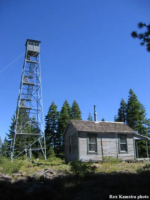
Aermotor fire tower on the Malheur NF, Grant County, Oregon; NHLR-registered 2002; no fire use, recommended for decommissioning in a 2018 draft plan; still listed as standing and unmanned in Cheryl Hill's Oregon list as of July 2026.
- Standing
- Restricted access
- Verified
Visit & stay
Not rentable. As far as we know, this lookout cannot be booked for overnight stays.
Access
Restricted access
Access is seasonal, gated or needs a permit. Check before you go. No closure order found. A 2018 draft plan recommends securing the towers against public access, and a 2021 trip report says the Forest deemed the tower unfit for use.
- Can you climb it?
- No
- Road to the top?
- Unknown
- Staffing
- Not staffed (as of 2026)
Facts
- Status
- Type
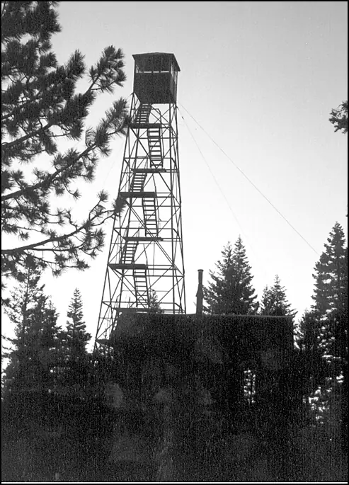
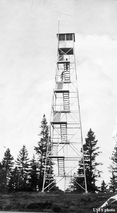
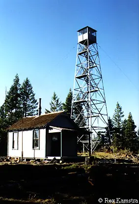
- Cab on a towerAermotor steel tower with 7 by 7 foot metal cab; 16 by 20 foot wood-frame living quartersThe design: Aermotor
- Built of
- Steel
- Built
- 1928
- Height
- 60 ft (18.3 m)
- Elevation
- 6,320 ft (1,926 m)
- Agency
- U.S. Forest Service, Malheur National Forest
- Land
- Federal land
- Location
- Grant County, Oregon
- Coordinates
- 43.97460, −119.15910
- Registers
- This entry
- VerifiedResearched, then checked independently. Updated 8 Oct 2026.
- Firefinder id
us-or-west-myrtle-butte
View from the cab
What you see from the cab: every ridge out to about 93 miles, the named peaks in sight, and other fire lookouts within view, worked out from terrain data in your browser.
Downloads about 3.8 MB of terrain data the first time.
Or see what it could see on the map: the ground in its line of sight.
History
Then and now
- 1928 Built'Built' field on NHLR detail pageSource: NHLR register entry
- 1929 BuiltForest Lookouts structural inventory, firelookout.com and a 2021 trip report date the tower to 1929. NHLR and Cheryl Hill's list say 1928.Sources: nhlr.org, firelookout.com, oregonlookouts.weebly.com
- 1929 StaffedLookout-fireman Truxton Dalton reported a smoke on July 12, 1929.Source: oregonlookouts.weebly.com
- 1930 Replaced by a new structureA 64-foot tower replaced the old 90-foot tree lookout, per a May 1930 letter quoted by Forest Lookouts.Source: oregonlookouts.weebly.com
- 1930 StaffedA local boy was employed as lookout; the travelers' register logged 180 visitors in the two seasons before May 1930.Source: oregonlookouts.weebly.com
- 1938 StaffedFireman Paul Gillingham was on duty at the lookout in October 1938.Source: oregonlookouts.weebly.com
- No record between 1938 and 2002
- 2002 Added to the National Historic Lookout RegisterRegistered July 16, 2002 as US 428, OR 53.Source: nhlr.org
- No record between 2002 and 2018
- 2018 Condition assessmentDraft Malheur National Forest facility plan says the tower is no longer needed for the fire program and recommends decommissioning it.Source: cherylhill.net
- 2021 EventTrip report describes the tower as abandoned but standing; living quarters had broken windows but were in fair condition; structures slated for decommission.Source: theroamingcivic.com
- 2026 EventCheryl Hill's Oregon list, which gives its count as of July 2026, describes the tower as still standing and lists it as unmanned.Source: cherylhill.net
- TodayStandingIt still stands, as far as our sources know.
Old maps of this spot
USGS topographic maps from the years a lookout stood may show it, often as a small symbol labelled “Lookout”. See the old topo maps around it on the Firefinder map, or find every scanned sheet of this spot on USGS TopoView (opens another site) (click the spot there to list them, with dates and downloads).
Story
Researched 8 Oct 2026, fact-checked.
West Myrtle Butte Lookout sits in Grant County, Oregon, on the Malheur National Forest, 27 miles north-northwest of Burns.1 The sources disagree about when it went up. The National Historic Lookout Register dates the tower to 1928, and so does Cheryl Hill's statewide list.2,3 Firelookout.com and the Forest Lookouts history say 1929, and the history quotes a Forest inventory that records a steel Aermotor tower erected that year beside a 16-by-20-foot wood-frame living quarters.1,4 The heights disagree as well, with figures of 60, 64, 67 and 80 feet.2,1,4,5
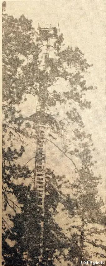
Before the tower, a lookout worked from a tree on the summit.1 A May 1930 letter quoted by the Forest Lookouts history says a 64-foot tower had replaced the old 90-foot tree.4
Staffing started early. In 1929 a lookout-fireman named Truxton Dalton was on the station, and he reported a smoke at 8 a.m. on July 12, about four miles away.4 He drove out by car and found a camp stove fire at the edge of the timber. A sheep herder nearby admitted he had put pitch wood in the stove to warm the water.4 A travelers' register kept over the two seasons before May 1930 logged 180 visitors, and the writer thought many more had visited without signing it.4 Fireman Paul Gillingham was on duty in October 1938.4 Cheryl Hill's Oregon list, which gives its count as of July 2026, shows the tower as unmanned.3
The Register lists the tower as US 428, OR 53, registered on July 16, 2002.2 It says that once the lookout was downgraded to emergency use, the Forest began renting the ground living quarters to raise money for upkeep.2 The Forest's current cabin rental page does not list this site. It names four former guard stations and Fall Mountain Lookout.6
A 2018 draft facility plan for the Malheur National Forest, as reported by Cheryl Hill's site, said West Myrtle Butte was no longer needed for the fire program. It recommended decommissioning the site and said the towers should at least be secured against public access. The plan also mentions preliminary talk of adding the site to the rental program.7
The most recent detailed condition report we found is a September 2021 trip report. It describes the tower and living quarters as abandoned but still standing, with broken windows in the living quarters but otherwise fair condition. It says the Forest had deemed the tower unfit for use and that all the structures were slated for decommissioning, yet the tower was open to climb.5 We found no closure order in the sources, so check with the Malheur National Forest before planning a visit. Because the Forest has judged the tower unfit for use, do not climb it.7,5
- West Myrtle Butte Fire Lookout Tower, Fire Lookout (firelookout.com), https://www.firelookout.com/or/westmyrtle.html (accessed 2026-10-08). ↩
- West Myrtle Butte Lookout, National Historic Lookout Register (nhlr.org), http://nhlr.org/lookouts/us/or/west-myrtle-butte-lookout/ (accessed 2026-10-08). ↩
- Oregon's Standing Lookouts, Cheryl Hill (cherylhill.net), https://cherylhill.net/firelookouts/oregons-standing-lookouts/ (accessed 2026-10-08). ↩
- West Myrtle Butte, Forest Lookouts (oregonlookouts.weebly.com), https://oregonlookouts.weebly.com/west-myrtle-butte.html (accessed 2026-10-08). ↩
- West Myrtle Butte L.O., The Roaming Civic (theroamingcivic.com), https://theroamingcivic.com/2021/09/04/west-myrtle-butte-lookout/ (accessed 2026-10-08). ↩
- Cabin Rentals, Malheur National Forest, U.S. Forest Service, https://www.fs.usda.gov/r06/malheur/recreation/cabin-rentals (accessed 2026-10-08). ↩
- Lookouts in the Malheur National Forest, Cheryl Hill (cherylhill.net), https://cherylhill.net/firelookouts/2018/02/19/lookouts-in-the-malheur-national-forest/ (accessed 2026-10-08). ↩
Photos
Photos keep their own rights and are shown with credit. Is one of these yours? You can ask for a different credit or for removal.
Sources
- National Historic Lookout Register (NHLR) (opens another site) Gave us: name, location, county, elevation, what it is built of, register numbers, agency, ownership, dates, photos, links National Historic Lookout Register (nhlr.org) · All rights reserved (American Resources, Inc.); facts extracted only, no prose copied. · retrieved 4 Oct 2026
- Forest Fire Lookout Association (FFLA) - US lookout lists (opens another site) Gave us: type, status, register numbers, links Forest Fire Lookout Association (firelookout.org) · No licence stated; facts extracted only, no prose copied. · retrieved 8 Oct 2026
- firelookout.com -- Rex Kamstra's Forest Fire Lookout Page (opens another site) Gave us: height, photos, links firelookout.com · No licence stated on the site; facts only (coordinates, elevation, built/destroyed years, design, agency). Photos mirrored with the site's stated credit. · retrieved 4 Oct 2026
- FOREST LOOKOUTS -- western US (Ron Kemnow's weebly sites) (opens another site) Gave us: design, links Ron Kemnow's Forest Lookouts sites (westlookouts, californialookouts, idaholookouts, montanalookouts, oregonlookouts and washingtonlookouts .weebly.com) · No licence stated; facts only (county, land manager, status word, coordinates where the page's own map widget gives them, township-range-section, height and design hints, links). The site's own newspaper quotes, citations and narrative are not reproduced. · retrieved 8 Oct 2026
- Every Lookout in Oregon (Cheryl Hill) (opens another site) Gave us: links Every Lookout in Oregon (Cheryl Hill, cherylhill.net) · No licence stated; facts only (name, agency, elevation, year built, design and height, status word, links). Posts' narrative and photos are not reproduced. · retrieved 8 Oct 2026
- Firefinder research Gave us: summary, design, status, agency, access, staffing, visiting details, dates, links, fact-check Firefinder research (sources cited in the story footnotes) · Our own research notes; each fact cites its source in the lookout's story
More about this lookout elsewhere
- NHLR register entry US 428 (nhlr.org) (opens another site)
- NHLR register entry (nhlr.org) (opens another site)
- Lookouts in the Malheur National Forest (Cheryl Hill (cherylhill.net)) (opens another site)
- Cabin Rentals (Malheur National Forest, U.S. Forest Service) (opens another site)
- West Myrtle Butte L.O. (The Roaming Civic (theroamingcivic.com)) (opens another site)
- FFLA Oregon lookout list (firelookout.org) (opens another site)
- West Myrtle Butte on firelookout.com (Rex Kamstra) (opens another site)
- West Myrtle Butte on Forest Lookouts, western US (Ron Kemnow) (opens another site)
- West Myrtle Butte on Every Lookout in Oregon (Cheryl Hill) (opens another site)
Firefinder takes facts (places, dates, numbers) from these sources and writes its own words. See all sources and licences.