Fire lookout · Josephine County, Oregon
Whiskey Peak Lookout Site
Josephine County, OR ground site on Whiskey Peak, Rogue River NF; L-4 cab (1930) salvaged in 1989 for the Sand Mountain Lookout; foundation reported still on the summit in 2019.
- Gone
- Open to the public
- Verified
Gone: The lookout no longer stands. Only the site is left. Cab salvaged in 1989 and rebuilt as the Sand Mountain Lookout near Sisters; a 2019 field-trip guide says the old foundation still remains on the summit
Visit & stay
Gone: site only. The lookout no longer stands, so there is nothing to climb or rent. You may still be able to visit the site.
Access
Open to the public. Forest Service lists Whisky Peak Trail #910, and a 2019 public field trip reached the summit; no closures or current conditions found in the sources read
- Road to the top?
- Unknown
- Trail
- Short, steep trail to the summit, Whisky Peak Trail #910; no lookout structure to climb
Facts
- Status
- Type
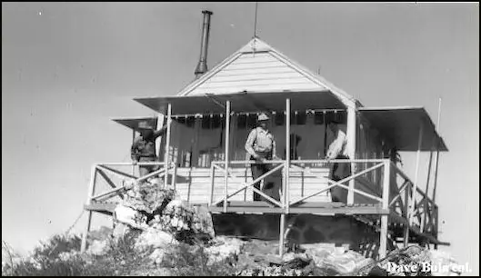
- Ground-level cabGround-mounted gable-roof L-4 cab, grange-hall style (1930 replacement)The design: L-4
- Built of
- WoodGoing by its design; no source says so in words.
- Also served as
- Aircraft Warning Service postDuring the Second World War it was staffed to spot and report aircraft.
- Built
- 1922
- Height
- Unknown
- Elevation
- 6,497 ft (1,980 m)
- Agency
- U.S. Forest Service, Rogue River National Forest
- Land
- Federal land
- Location
- Josephine County, Oregon
- Coordinates
- 42.02040, −123.26154
- Registers
- This entry
- VerifiedResearched, then checked independently. Updated 9 Oct 2026.
- Firefinder id
us-or-whiskey-peak
View from the cab
What the lookout saw from its cab: every ridge out to about 93 miles, the named peaks in sight, and other fire lookouts within view, worked out from terrain data in your browser.
This lookout is gone. The view is reconstructed from its recorded site and a typical height for a lookout like it.
Downloads about 3.6 MB of terrain data the first time.
Or see what it could see on the map: the ground in its line of sight.
History
Then and now
- 1922 BuiltSmall frame cabin on the summit (FFLOS, firelookout.com); Oregon Lookouts quotes a Rogue River NF history dating the lookout house to 1924Sources: firetower.org, firelookout.com, oregonlookouts.weebly.com
- 1929 BurnedLookout house destroyed by fire in October 1929; lookout Cal Winningham lost his belongingsSource: oregonlookouts.weebly.com
- 1930 RebuiltReplacement ground-mounted gable-roof L-4 cab completed in October 1930 with a concrete floorSources: firetower.org, oregonlookouts.weebly.com
- 1935 StaffedMr. and Mrs. George Ellis in charge of the lookout for the summerSource: oregonlookouts.weebly.com
- 1942 EventAircraft Warning Service post activated August 26, 1942; FFLOS says an AWS cabin was built here in 1942Sources: firetower.org, oregonlookouts.weebly.com
- 1943 EventAircraft Warning Service post deactivated October 16, 1943; Forest Service retained the structures for fire spottingSource: oregonlookouts.weebly.com
- No record between 1943 and 1989
- 1989 MovedCab salvaged, bundled and flown out by helicopter for the Sand Mountain Lookout near SistersSources: firetower.org, firelookout.com, sandmountain.org
- No record between 1989 and 2011
- 2011 Added to the Former Fire Lookout Sites RegisterRegistered April 22, 2011 as US 935, OR 293; nominated by Ray KresekSource: firetower.org
- TodayGoneThe lookout no longer stands. Only the site is left. When it came down is not recorded.
Old maps of this spot
USGS topographic maps from the years a lookout stood may show it, often as a small symbol labelled “Lookout”. See the old topo maps around it on the Firefinder map, or find every scanned sheet of this spot on USGS TopoView (opens another site) (click the spot there to list them, with dates and downloads).
Story
Researched 9 Oct 2026, fact-checked.
Whiskey Peak lies in Josephine County, Oregon, on the Rogue River National Forest, about 28 miles southwest of Medford.1,2 The first lookout house went up in 1924, according to a Rogue River National Forest history quoted by Oregon Lookouts.3 The Former Fire Lookout Sites register instead dates a small frame cabin on the summit to 1922.1
A fire destroyed that house in October 1929 while the lookout, Cal Winningham, was outside repairing a chimney.3 His belongings and the government supplies on hand burned with it.3 The replacement, a ground-mounted, gable-roof L-4 cab, was finished in October 1930.1,3 The plan called for a concrete floor.3 Crews hauled sand and gravel up from the Big Applegate by tractor and pack horse.3
Lookouts in the 1930s included Mr. and Mrs. George Ellis in 1935.3 In August 1936 a rifle accident seriously injured the lookout, James MacLean.3 Two CCC men from Camp Applegate covered the post until Jim Arnold took over.3 From August 1942 to October 1943 the site was an Aircraft Warning Service post, and two observers manned it through one winter.3 Afterward the Forest Service kept the structures for fire spotting.3
The cab sat abandoned for several years.1 In 1989 it was salvaged for the new Sand Mountain Lookout near Sisters.1,2 The Sand Mountain Society says it chose the Whisky Peak cab because its grange-hall style matched the original Sand Mountain lookout, even though the cab was badly run down and the other option, Pearsoll Peak, was in better shape.4 Helicopter support was arranged to fly the bundled pieces out.4
No cab stands on Whiskey Peak now.1 A 2019 Native Plant Society field-trip guide says the old lookout foundation still remains on the summit.5 The same guide describes a short, steep trail from Forest Service roads that are mostly in good shape, with limited parking at the trailhead.5 The Forest Service lists the route as Whisky Peak Trail #910.6 The sources we read do not describe current closures or conditions, so check with the Rogue River–Siskiyou National Forest before going.
- Whiskey Peak Lookout Site, Former Fire Lookout Sites Register, http://firetower.org/lookouts/us/or/whiskey-peak-lookout-site/ (accessed 2026-10-09). ↩
- Whiskey Peak Fire Lookout Cabin, firelookout.com, https://www.firelookout.com/or/whiskypeak.html (accessed 2026-10-09). ↩
- Whiskey Peak, Forest Lookouts, Oregon Lookouts, https://oregonlookouts.weebly.com/whiskey-peak.html (accessed 2026-10-09). ↩
- Pearsoll Peak Lookout, Sand Mountain Society, https://sandmountain.org/projects/pearsoll-peak/ (accessed 2026-10-09). ↩
- Whisky Peak, Field Trip #34, Native Plant Society of Oregon Siskiyou chapter, https://siskiyou.npsoregon.org/annualmeeting2019/fieldtrips.php?id=Whisky%20Peak (accessed 2026-10-09). ↩
- Whisky Peak Trail #910, Rogue River-Siskiyou National Forest, https://www.fs.usda.gov/r06/rogue-siskiyou/recreation/trails/whisky-peak-trail-910 (accessed 2026-10-09). ↩
Photos
Photos keep their own rights and are shown with credit. Is one of these yours? You can ask for a different credit or for removal.
Sources
- Former Fire Lookout Sites Register (FFLOS) (opens another site) Gave us: name, location, county, elevation, what it is built of, wartime use, register numbers, agency, ownership, dates, photos, links Former Fire Lookout Sites Register (firetower.org) · All rights reserved (American Resources, Inc.); facts extracted only, no prose copied. · retrieved 4 Oct 2026
- Forest Fire Lookout Association (FFLA) - US lookout lists (opens another site) Gave us: type, status, register numbers, links Forest Fire Lookout Association (firelookout.org) · No licence stated; facts extracted only, no prose copied. · retrieved 8 Oct 2026
- firelookout.com -- Rex Kamstra's Forest Fire Lookout Page (opens another site) Gave us: links firelookout.com · No licence stated on the site; facts only (coordinates, elevation, built/destroyed years, design, agency). Photos mirrored with the site's stated credit. · retrieved 4 Oct 2026
- Sand Mountain Society (opens another site) Gave us: dates, links Sand Mountain Society (sandmountain.org) · No licence stated; facts only (dates, names, dimensions, the kind of work done). Every note is our own wording and every event links to the Sand Mountain Society page it comes from. Positions are copied from the NHLR and FFLOS records. · retrieved 8 Oct 2026
- FOREST LOOKOUTS -- western US (Ron Kemnow's weebly sites) (opens another site) Gave us: links Ron Kemnow's Forest Lookouts sites (westlookouts, californialookouts, idaholookouts, montanalookouts, oregonlookouts and washingtonlookouts .weebly.com) · No licence stated; facts only (county, land manager, status word, coordinates where the page's own map widget gives them, township-range-section, height and design hints, links). The site's own newspaper quotes, citations and narrative are not reproduced. · retrieved 8 Oct 2026
- Firefinder research Gave us: summary, design, status, agency, access, visiting details, dates, links, fact-check Firefinder research (sources cited in the story footnotes) · Our own research notes; each fact cites its source in the lookout's story
More about this lookout elsewhere
- FFLOS register entry US 935 (firetower.org) (opens another site)
- Whisky Peak, Field Trip #34 (Native Plant Society of Oregon, Siskiyou chapter) (opens another site)
- Whisky Peak Trail #910 (Rogue River-Siskiyou National Forest (fs.usda.gov)) (opens another site)
- FFLA Oregon lookout list (firelookout.org) (opens another site)
- Sand Mountain Society: work on Whisky Peak Lookout (opens another site)
- Whisky Peak on firelookout.com (Rex Kamstra) (opens another site)
- Whiskey Peak on Forest Lookouts, western US (Ron Kemnow) (opens another site)
Firefinder takes facts (places, dates, numbers) from these sources and writes its own words. See all sources and licences.