Fire lookout · Douglas County, Oregon
White Rock Lookout Site
White Rock lookout, Douglas County, OR: cabin built 1917-1919, D-6 cupola cabin 1923, lightning damage 1931, removed 1967 or 1970; no source describes the site today.
- Gone
- Access unknown
- Verified
Gone: The lookout no longer stands. Only the site is left. Removed in 1970 per the register and destroyed that year per firelookout.com; Forest Lookouts gives 1967 for removal. No source describes the site today.
Visit & stay
Gone: site only. The lookout no longer stands, so there is nothing to climb or rent.
Access
Access unknown
We do not know the access rules. Check with the land manager before you go.
- Road to the top?
- Unknown
- Trail
- A three-mile trail from South Myrtle to the station was completed in 1917 (Forest Lookouts quoting a newspaper). No source describes access to the site today.
Facts
- Status
- Type
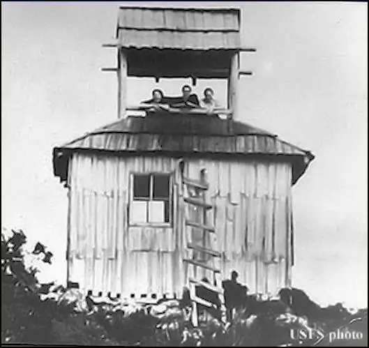
- Ground-level cabCabin with an open-air cupola, replaced in 1923 by a D-6 cupola cabin (register)The design: D-6
- Built of
- WoodGoing by its design; no source says so in words.
- Built
- 1917
- Height
- 10 ft (3.0 m)
- Elevation
- 4,019 ft (1,225 m)
- Agency
- Douglas FPA
- Land
- Unknown
- Location
- Douglas County, Oregon
- Coordinates
- 43.12022, −123.03827
- Registers
- This entry
- VerifiedResearched, then checked independently. Updated 9 Oct 2026.
- Firefinder id
us-or-white-rock
View from the cab
What the lookout saw from its cab: every ridge out to about 93 miles, the named peaks in sight, and other fire lookouts within view, worked out from terrain data in your browser.
This lookout is gone. The view is reconstructed from its recorded site and its recorded height.
Downloads about 3.6 MB of terrain data the first time.
Or see what it could see on the map: the ground in its line of sight.
History
Then and now
- 1917 BuiltConstruction of the station building under way in September 1917 (Forest Lookouts quoting the Riddle Tribune); the register gives 1919Source: oregonlookouts.weebly.com
- 1919 BuiltCabin with an open-air cupola built (register and firelookout.com)Sources: firetower.org, firelookout.com
- 1923 Replaced by a new structureD-6 cupola cabin replaced the 1919 cabin; Forest Lookouts quotes an August 1923 report of knocked-down buildings shipped to the siteSources: firetower.org, firelookout.com, oregonlookouts.weebly.com
- 1926 Built14-by-16 log cabin constructed for $10 (Forest Lookouts)Source: oregonlookouts.weebly.com
- 1926 FireLookout reported 25 to 30 incendiary fires on the divide between North and South Myrtle creeksSource: oregonlookouts.weebly.com
- 1928 BuiltGround house with a 7-by-7 cupola constructed (Forest Lookouts)Source: oregonlookouts.weebly.com
- 1930 StaffedNeil Tripp at the White Rock lookout station; away a few days through illness in JulySource: oregonlookouts.weebly.com
- 1931 EventReport of vandalism turned out to be lightning damage; 15 of 18 windows brokenSource: oregonlookouts.weebly.com
- 1943 ClosedArmy deactivated the White Rock AWS stationSource: oregonlookouts.weebly.com
- No record between 1943 and 1967
- 1967 RemovedForest Lookouts: lookout discontinued and removedSource: oregonlookouts.weebly.com
- 1970 RemovedRegister: removed in 1970; firelookout.com: destroyed in 1970Sources: firetower.org, firelookout.com
- No record between 1970 and 2011
- 2011 Added to the Former Fire Lookout Sites RegisterRegistered April 22, 2011 as US 936, OR 294Source: firetower.org
- TodayGoneThe lookout no longer stands. Only the site is left.
Old maps of this spot
USGS topographic maps from the years a lookout stood may show it, often as a small symbol labelled “Lookout”. See the old topo maps around it on the Firefinder map, or find every scanned sheet of this spot on USGS TopoView (opens another site) (click the spot there to list them, with dates and downloads).
Story
Researched 9 Oct 2026, fact-checked.
The White Rock lookout stood on a rocky summit about 17 miles southeast of Roseburg, in Douglas County, Oregon.1,2 Work on a new station building was under way in September 1917, when the Riddle Tribune reported that the structure would be walled with glass.2 In July 1917 a new three-mile trail from South Myrtle to the station had been completed.2
The register dates the first building to 1919, a cabin with an open-air cupola, and says a D-6 cupola cabin replaced it in 1923.3 Forest Lookouts quotes an August 1923 report of two lookout houses under construction that summer, one of them at White Rock, cut out in Roseburg and shipped in knocked-down pieces.2 Forest Lookouts also lists a 14-by-16 log cabin built in 1926 for $10, and a ground house with a 7-by-7 cupola in 1928.2 Those entries do not match the register's account, so the building history is unclear.3,2
Forest Ranger U. F. Collins and Forest Inspector Robert Wallace were busy building the new station in 1917.2 In July 1930 Neil Tripp had been at the lookout station, but illness kept him at home for a few days.2 In July 1926 the lookout reported 25 to 30 deliberately set fires on the divide between North and South Myrtle creeks.2 In January 1931 reports said vandals had damaged the station, but the supervising warden found that lightning had struck it, breaking 15 of its 18 windows.2 In October 1943 the Army deactivated the White Rock AWS station.2
The register says the lookout was removed in 1970.3 Firelookout.com says it was destroyed that year.1 Forest Lookouts says it was discontinued and removed in 1967.2 The sources disagree on the year.
None of the three sources describes what remains at the summit today, or whether the public can reach it.
- White Rock Fire Lookout Cabin, firelookout.com, https://www.firelookout.com/or/whiterock.html (accessed 2026-10-09). ↩
- White Rock, Forest Lookouts, https://oregonlookouts.weebly.com/white-rock.html (accessed 2026-10-09). ↩
- White Rock Lookout Site, Former Fire Lookout Sites, http://firetower.org/lookouts/us/or/white-rock-lookout-site/ (accessed 2026-10-09). ↩
Photos
Photos keep their own rights and are shown with credit. Is one of these yours? You can ask for a different credit or for removal.
Sources
- Former Fire Lookout Sites Register (FFLOS) (opens another site) Gave us: name, location, county, elevation, what it is built of, register numbers, agency, dates, photos, links Former Fire Lookout Sites Register (firetower.org) · All rights reserved (American Resources, Inc.); facts extracted only, no prose copied. · retrieved 4 Oct 2026
- Forest Fire Lookout Association (FFLA) - US lookout lists (opens another site) Gave us: type, status, register numbers, links Forest Fire Lookout Association (firelookout.org) · No licence stated; facts extracted only, no prose copied. · retrieved 8 Oct 2026
- firelookout.com -- Rex Kamstra's Forest Fire Lookout Page (opens another site) Gave us: links firelookout.com · No licence stated on the site; facts only (coordinates, elevation, built/destroyed years, design, agency). Photos mirrored with the site's stated credit. · retrieved 4 Oct 2026
- FOREST LOOKOUTS -- western US (Ron Kemnow's weebly sites) (opens another site) Gave us: height, links Ron Kemnow's Forest Lookouts sites (westlookouts, californialookouts, idaholookouts, montanalookouts, oregonlookouts and washingtonlookouts .weebly.com) · No licence stated; facts only (county, land manager, status word, coordinates where the page's own map widget gives them, township-range-section, height and design hints, links). The site's own newspaper quotes, citations and narrative are not reproduced. · retrieved 8 Oct 2026
- Firefinder research Gave us: summary, design, status, agency, staffing, visiting details, dates, links, fact-check Firefinder research (sources cited in the story footnotes) · Our own research notes; each fact cites its source in the lookout's story
More about this lookout elsewhere
- FFLOS register entry US 936 (firetower.org) (opens another site)
- FFLA Oregon lookout list (firelookout.org) (opens another site)
- White Rock on firelookout.com (Rex Kamstra) (opens another site)
- White Rock on Forest Lookouts, western US (Ron Kemnow) (opens another site)
Firefinder takes facts (places, dates, numbers) from these sources and writes its own words. See all sources and licences.