Fire lookout · Lackawanna County, Pennsylvania
Tark Hill Tower Site
Also known as Bear Springs
Tark Hill tower near Suscon and Dupont: built 1951, dismantled for an FAA site in 1960. A storymap's Bear Springs tower (dated 1959) may be a different structure. Site today unknown.
- Gone
- Access unknown
- Verified
Gone: The lookout no longer stands. Only the site is left. The register lists it as a former site. The storymap's Bear Springs tower was replaced in 2018; it does not say a structure stands at this site.
Visit & stay
Gone: site only. The lookout no longer stands, so there is nothing to climb or rent.
Access
Access unknown
We do not know the access rules. Check with the land manager before you go.
- Road to the top?
- Unknown
Facts
- Status
- sources disagree
- Type
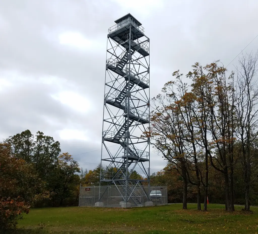
- Cab on a towerSteel towerThe design: Aermotor
- Built of
- SteelGoing by its design; no source says so in words.
- Built
- 1951
- Height
- 80 ft (24.4 m)
- Elevation
- Unknown
- Agency
- State Game Lands #91
- Land
- State land
- Location
- Lackawanna County, Pennsylvania
- Coordinates
- 41.26290, −75.70610
- Registers
- This entry
- VerifiedResearched, then checked independently. Updated 9 Oct 2026.
- Firefinder id
us-pa-bear-springs
View from the cab
What the lookout saw from its cab: every ridge out to about 93 miles, the named peaks in sight, and other fire lookouts within view, worked out from terrain data in your browser.
This lookout is gone. The view is reconstructed from its recorded site and its recorded height.
Downloads about 3.7 MB of terrain data the first time.
Or see what it could see on the map: the ground in its line of sight.
History
Then and now
- 1951 BuiltRegister gives 1951 and the 1951 notice says the tower was located there to replace Big Shinny TowerSources: easternuslookouts.weebly.com, firetower.org
- 1952 First staffedOpened with James Reap in chargeSource: easternuslookouts.weebly.com
- 1955 StaffedNotice lists James Reap as operatorSource: easternuslookouts.weebly.com
- 1959 BuiltStorymap date for the tower it calls Bear Springs; no other source gives it and none ties that tower to this siteSource: arcgis.com
- 1960 RemovedTark Hill tower dismantled because the FAA wanted the site for a VORTAC facilitySource: easternuslookouts.weebly.com
- 1960 Replaced by a new structureRegister gives 1960 as the replacement year; the August 1960 notice describes a new 90-foot tower south of DupontSources: easternuslookouts.weebly.com, firetower.org
- No record between 1960 and 2008
- 2008 Added to the Former Fire Lookout Sites RegisterDate registered per FFLOS detail page: September 16, 2008Source: FFLOS register entry
- 2018 Replaced by a new structureStorymap says the Bear Springs tower was replaced in 2018; no source ties that tower to this siteSource: arcgis.com
- TodayGoneThe lookout no longer stands. Only the site is left. When it came down is not recorded.
Old maps of this spot
USGS topographic maps from the years a lookout stood may show it, often as a small symbol labelled “Lookout”. See the old topo maps around it on the Firefinder map, or find every scanned sheet of this spot on USGS TopoView (opens another site) (click the spot there to list them, with dates and downloads).
Story
Researched 10 Oct 2026, fact-checked.
Tark Hill was a state fire tower near Suscon, about five miles from Dupont.1 The state located it there in 1951 to replace the Big Shinny tower, which a windstorm had blown down the previous November.1 The register gives 1951 as the build year.2 James J. Reap manned the tower, and a 1952 notice said it had opened with him in charge.1
By 1955 a notice listed Reap as the operator of the Tark Hill tower near Dupont, and named Tark Hill among the Luzerne County towers.1
In August 1960 the Wilkes-Barre Record reported that the tower had come down because the Federal Aviation Administration preferred the site for a VORTAC, an aircraft navigation beacon.1 A new 90-foot steel tower was being built south of Dupont to replace it.1
The sources disagree on dates. The register gives 1951 for the build and 1960 for the replacement.2 A state storymap calls a tower Bear Springs, places it in Luzerne County on State Game Lands No. 91, and dates it to 1959.3 It says the tower was replaced in 2018 and gives a height of 80 feet.3 The 1960 notice gave the new tower a height of 90 feet.1 No source says whether that tower and the storymap's Bear Springs are the same structure.
The storymap places Bear Springs on State Game Lands No. 91, and the Game Commission's map says those lands are open for general use year round.3,4 No source I found ties that site to Tark Hill, and none describes what, if anything, remains there. The storymap's location line does not say whether it refers to the 1959 tower or its 2018 replacement.3
- Tark Hill, Eastern US Lookouts (newspaper notices transcribed from 1951 to 1960), https://easternuslookouts.weebly.com/tark-hill.html (accessed 2026-10-10). ↩
- Tark Hill Tower Site, Former Fire Lookout Sites register, http://firetower.org/lookouts/us/pa/tark-hill-tower-site/ (accessed 2026-10-10). ↩
- Fire Towers of Pennsylvania, StoryMap by Shawn Lesitsky (ArcGIS item data), https://www.arcgis.com/sharing/rest/content/items/ed47c97ebe7246868ce8ef3e7139a0b4/data (accessed 2026-10-10). ↩
- State Game Lands No. 91 sportsmen's recreation map, Pennsylvania Game Commission, https://www.pa.gov/content/dam/copapwp-pagov/en/pgc/documents/habitat-management/sgl-maps-and-routes/sgl__091.pdf (accessed 2026-10-10). ↩
Photos
Photos keep their own rights and are shown with credit. Is one of these yours? You can ask for a different credit or for removal.
Where sources disagree
We show disagreements between sources instead of quietly picking one. If you know which is right, please tell us.
Sources disagree on whether it still stands.
- FFLOS: Gone
- Fire Towers of Pennsylvania (ArcGIS StoryMap, Shawn Lesitsky): Standing
- FOREST LOOKOUTS -- eastern US (easternuslookouts.weebly.com): Gone
Sources
- Former Fire Lookout Sites Register (FFLOS) (opens another site) Gave us: name, county, status, register numbers, dates, links Former Fire Lookout Sites Register (firetower.org) · All rights reserved (American Resources, Inc.); facts extracted only, no prose copied. · retrieved 4 Oct 2026
- Fire Towers of Pennsylvania (ArcGIS StoryMap, Shawn Lesitsky) (opens another site) Gave us: type, what it is built of, design, height, agency, ownership, dates, photos, links Pennsylvania fire towers StoryMap (ArcGIS) · No licence stated; facts only (county, agency, built year, height, builder). · retrieved 4 Oct 2026
- FOREST LOOKOUTS -- eastern US (easternuslookouts.weebly.com) (opens another site) Gave us: location, links easternuslookouts.weebly.com · No licence stated; facts only (county, coordinates where the page's own map widget gives them, status, height, design hints, register links). The site's own historical quotes, newspaper citations and narrative are not reproduced. · retrieved 8 Oct 2026
- Firefinder research Gave us: summary, design, status, dates, links, fact-check Firefinder research (sources cited in the story footnotes) · Our own research notes; each fact cites its source in the lookout's story
More about this lookout elsewhere
- FFLOS register entry US 505 (firetower.org) (opens another site)
- Fire Towers of Pennsylvania (StoryMap, ArcGIS item data) (Shawn Lesitsky, ArcGIS StoryMaps) (opens another site)
- State Game Lands No. 91 sportsmen's recreation map (Pennsylvania Game Commission) (opens another site)
- Fire Towers of Pennsylvania StoryMap (Shawn Lesitsky) (opens another site)
- Tark Hill (easternuslookouts.weebly.com) (opens another site)
Firefinder takes facts (places, dates, numbers) from these sources and writes its own words. See all sources and licences.