Fire lookout · Cumberland County, Pennsylvania
Big Flat Fire Tower
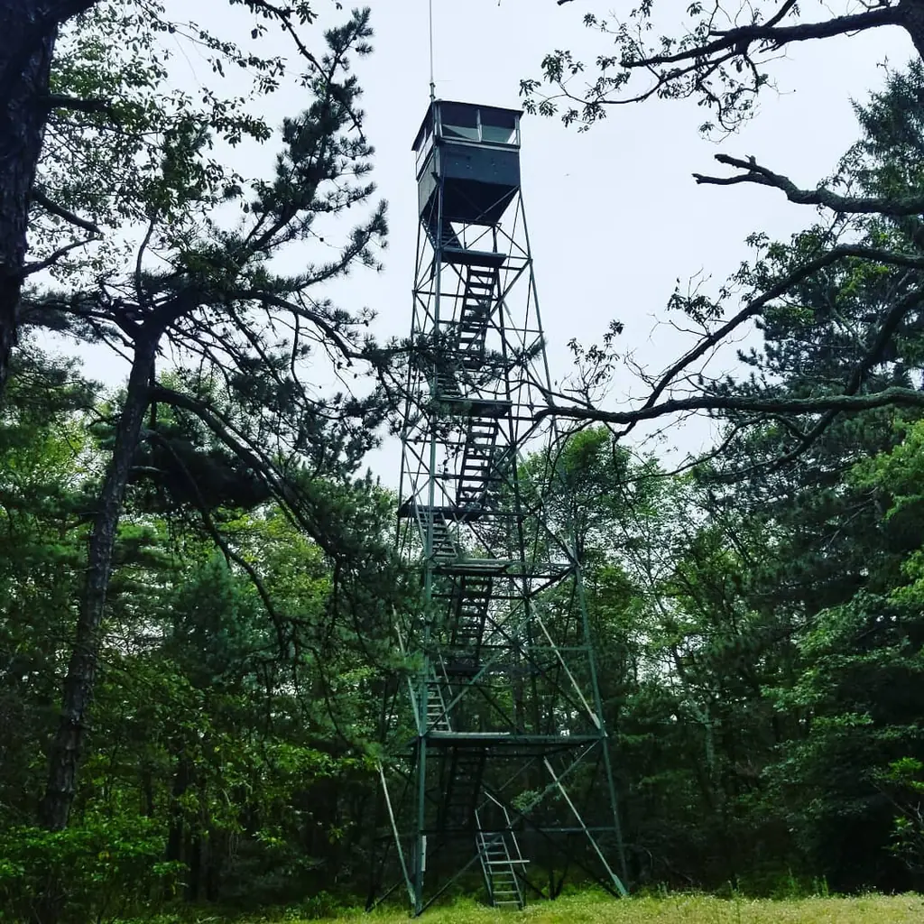
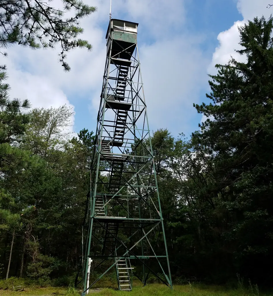
1921 Pennsylvania Department of Forestry steel Aermotor tower on South Mountain in Michaux State Forest; its current status is unresolved after a 2021 demolition contract.
- Status unknown
- Open to the public
- Verified
Status unknown: We do not know yet whether it still stands. Listed in 2018, but a 2021 online contract called for demolition and a 2024 visitor found nothing to see at the site. Completion of the demolition is not confirmed.
Visit & stay
Not rentable. As far as we know, this lookout cannot be booked for overnight stays.
Access
Open to the public. State-owned Michaux State Forest land per a 1942 survey, reached by a road walk off the Appalachian Trail past several homes. A 2024 visitor found nothing to see at the site.
- Can you climb it?
- Unknown
- Road to the top?
- Unknown
- Trail
- Short detour from the Appalachian Trail off Shippensburg Road; a 2024 visitor found nothing to see at the site.
- Staffing
- Unknown
Facts
- Status
- sources disagree
- Type
- Cab on a towerSteel Aermotor tower with a glass-enclosed cabThe design: Aermotor
- Built of
- Steel
- Built
- 1921
- Height
- 60 ft (18.3 m)
- Elevation
- 2,064 ft (629 m)
- Agency
- Pennsylvania Bureau of Forestry
- Land
- State land
- Location
- Cumberland County, Pennsylvania
- Coordinates
- 40.00185, −77.40743
- Registers
- This entry
- VerifiedResearched, then checked independently. Updated 8 Oct 2026.
- Firefinder id
us-pa-big-flat
View from the cab
What you see from the cab: every ridge out to about 93 miles, the named peaks in sight, and other fire lookouts within view, worked out from terrain data in your browser.
Downloads about 3.4 MB of terrain data the first time.
Or see what it could see on the map: the ground in its line of sight.
History
Then and now
- 1921 BuiltBuilt by the Pennsylvania Department of Forestry as one of 50 planned that year; height given as 60 ft by NHLR and the 1921 noticeSources: nhlr.org, willhiteweb.com, easternuslookouts.weebly.com
- No record between 1921 and 1936
- 1936 EventNewspaper gave driving directions to the tower and praised the view over the Cumberland ValleySource: easternuslookouts.weebly.com
- 1942 EventSurvey described a four-legged steel tower, 75 ft high, with a glass-enclosed cab, on state-owned propertySource: willhiteweb.com
- 1952 Condition assessmentSurvey: external sheeting in poor repair, frame intact and in good conditionSource: willhiteweb.com
- No record between 1952 and 1972
- 1972 StaffedLookout observer recordedSource: willhiteweb.com
- 1973 StaffedLookout observer recordedSource: willhiteweb.com
- No record between 1973 and 2006
- 2006 EventTower still there, per WillhiteSource: willhiteweb.com
- 2018 Added to the National Historic Lookout RegisterRegistered July 30, 2018, nominated by Kristin ReynoldsSource: nhlr.org
- 2021 EventOnline contract for demolition of a 60-ft steel tower, a cabin, a meter box, an electric panel and concrete foundation. Completion not confirmed.Source: willhiteweb.com
- 2024 EventVisitor found nothing to see at the site and believed the footings were to be removedSource: willhiteweb.com
- TodayStatus unknownWe do not know whether it still stands.
Old maps of this spot
USGS topographic maps from the years a lookout stood may show it, often as a small symbol labelled “Lookout”. See the old topo maps around it on the Firefinder map, or find every scanned sheet of this spot on USGS TopoView (opens another site) (click the spot there to list them, with dates and downloads).
Story
Researched 8 Oct 2026, fact-checked.
Big Flat is a high, flat mountain on South Mountain in Cumberland County, inside Michaux State Forest, and its steel fire tower dates from 1921.1,2,3 The Pennsylvania Department of Forestry built it as one of 50 planned that year.2 A November 1921 notice placed the tower at an elevation of about 2,080 feet and said it was connected to the forester by a commercial telephone line.3
Reports disagree on its height. The Register and the 1921 notice both give 60 feet.1,3 Willhite's history opens with an 80-foot Aermotor tower, then notes that other reports say it was 60 feet tall. A 1942 survey described it as 75 feet high, with a glass-enclosed cab.2
A 1936 newspaper item gave driving directions to the tower and praised the view over the Cumberland Valley. On clear days, it said, the Gettysburg battlefield monuments could be seen.3 Observers were recorded at the tower in 1972 and 1973.2
The Register listed the tower on July 30, 2018, nominated by Kristin Reynolds.1 A 1952 survey found the external sheeting in poor repair, though the frame was intact and in good condition.2 The tower was still there in 2006.2 A 2021 online contract called for the demolition of a 60-foot steel tower, a cabin and concrete foundations.2 A 2024 visitor found no visible remains at the site and believed the footings were to be removed under that contract.2
The Pennsylvania Bureau of Forestry administers the tower.1 A 1942 survey described the property as state-owned land.2 The site is reached by a road walk off the Appalachian Trail, past several homes, near Shippensburg Road.2 Whether the tower still stands is unresolved. The 2021 contract and the 2024 visit suggest it may be gone, but I found no record that the demolition was finished.2 Check with the Bureau before you visit, and do not climb any remaining structure.
- Big Flat Fire Tower, National Historic Lookout Register, http://nhlr.org/lookouts/us/pa/big-flat-fire-tower/ (accessed 2026-10-08). ↩
- Big Flat Fire Tower, WillhiteWeb.com, https://willhiteweb.com/appalachian_trail/fire_lookouts/big_flat/fire_tower_044.htm (accessed 2026-10-08). ↩
- Big Flat, Forest Lookouts (Eastern US), https://easternuslookouts.weebly.com/big-flat.html (accessed 2026-10-08). ↩
Photos
Photos keep their own rights and are shown with credit. Is one of these yours? You can ask for a different credit or for removal.
Where sources disagree
We show disagreements between sources instead of quietly picking one. If you know which is right, please tell us.
Sources disagree on whether it still stands.
- Firefinder research: Status unknown
- NHLR: Standing
Research (2026-10-08) gives unknown where the source records give standing. The page shows the researched status; please tell us if it is wrong.
Sources
- National Historic Lookout Register (NHLR) (opens another site) Gave us: name, location, county, elevation, type, what it is built of, status, register numbers, agency, dates, photos, links National Historic Lookout Register (nhlr.org) · All rights reserved (American Resources, Inc.); facts extracted only, no prose copied. · retrieved 4 Oct 2026
- Fire Towers of Pennsylvania (ArcGIS StoryMap, Shawn Lesitsky) (opens another site) Gave us: design, height, ownership, photos, links Pennsylvania fire towers StoryMap (ArcGIS) · No licence stated; facts only (county, agency, built year, height, builder). · retrieved 4 Oct 2026
- FOREST LOOKOUTS -- eastern US (easternuslookouts.weebly.com) (opens another site) Gave us: links easternuslookouts.weebly.com · No licence stated; facts only (county, coordinates where the page's own map widget gives them, status, height, design hints, register links). The site's own historical quotes, newspaper citations and narrative are not reproduced. · retrieved 8 Oct 2026
- Firefinder research Gave us: summary, design, height, status, agency, access, visiting details, dates, links, fact-check Firefinder research (sources cited in the story footnotes) · Our own research notes; each fact cites its source in the lookout's story
More about this lookout elsewhere
- NHLR register entry US 1285 (nhlr.org) (opens another site)
- NHLR register entry (nhlr.org) (opens another site)
- Big Flat Fire Tower (WillhiteWeb.com) (opens another site)
- Fire Towers of Pennsylvania StoryMap (Shawn Lesitsky) (opens another site)
- Big Flat (easternuslookouts.weebly.com) (opens another site)
Firefinder takes facts (places, dates, numbers) from these sources and writes its own words. See all sources and licences.