Fire lookout · Jefferson County, Pennsylvania
Hays Lot
Also known as Hays Lookout Tower
Jefferson County, PA fire tower in use by April 1922, with a visitor register past 7,500 names by 1939; the 1994 end of fire watch rests on one secondary source.
- Standing
- Access unknown
- Verified
Visit & stay
Not rentable. As far as we know, this lookout cannot be booked for overnight stays.
Access
Access unknown
We do not know the access rules. Check with the land manager before you go.
- Can you climb it?
- Unknown
- Road to the top?
- Unknown
- Staffing
- Unknown
Facts
- Status
- Type
- Cab on a towerAermotorThe design: Aermotor
- Built of
- SteelGoing by its design; no source says so in words.
- Built
- 1921
- Height
- 86 ft (26.2 m)
- Elevation
- 2,014 ft (614 m)
- Agency
- Pennsylvania Department of Forestry, per a 1922 report; current agency not confirmed
- Land
- State land
- Location
- Jefferson County, Pennsylvania
- Coordinates
- 41.31727, −78.99433
- Registers
- Not on a lookout register
- This entry
- VerifiedResearched, then checked independently. Updated 9 Oct 2026.
- Firefinder id
us-pa-hays-lot
View from the cab
What you see from the cab: every ridge out to about 93 miles, the named peaks in sight, and other fire lookouts within view, worked out from terrain data in your browser.
Downloads about 3.7 MB of terrain data the first time.
Or see what it could see on the map: the ground in its line of sight.
History
Then and now
- 1921 BuiltEstablished in 1921 per onX; the earliest date we foundSource: onxmaps.com
- 1922 StaffedSherman Seanor hired as watchman, reported April 1922Source: easternuslookouts.weebly.com
- 1923 StaffedHerman Seanor described as towerman, December 1923Source: easternuslookouts.weebly.com
- No record between 1923 and 1938
- 1938 EventUSGS survey mark described as set directly under the tower's centerSource: easternuslookouts.weebly.com
- 1939 EventVisitor register passed 7,500 names by September 1939Source: easternuslookouts.weebly.com
- 1945 BuiltSource: Fire Towers of Pennsylvania (ArcGIS StoryMap, Shawn Lesitsky)
- No record between 1945 and 1994
- 1994 EventonX says the tower was used for fire detection until 1994; single secondary sourceSource: onxmaps.com
- TodayStandingIt still stands, as far as our sources know.
Old maps of this spot
USGS topographic maps from the years a lookout stood may show it, often as a small symbol labelled “Lookout”. See the old topo maps around it on the Firefinder map, or find every scanned sheet of this spot on USGS TopoView (opens another site) (click the spot there to list them, with dates and downloads).
Story
Researched 9 Oct 2026, fact-checked.
Hays Lot is a fire tower in northern Jefferson County, Pennsylvania, near Sigel.1 The earliest date we found is 1921. An onX trail note says the tower was established that year and used for forest fire detection until 1994.2 By April 1922 the New Castle News reported that Sherman Seanor, of Sigel, had been hired as the tower's watchman.1
The state's Department of Forestry ran the lookout in those years.1 In August 1922 District Forester Zerby reported to the department's Harrisburg office that more than 100 visitors had come on Sundays that summer.1 He planned benches and tables among the trees at the base of the tower, along with a walled-in spring and an open fireplace where visitors could cook a lunch.1 By December 1923 Herman Seanor was the towerman.1
Visitors signed a register book kept at the tower.1 By September 1939 the Clarion Democrat counted more than 7,500 names.1 Most came from Jefferson County and nearby counties. Visitors came from every state, along with an odd visitor from Canada and China.1 A 1938 U.S. Geological Survey description places a survey marker directly under the tower's center, so the tower stood by then.1
We did not find a description of the tower's design or height. The 1994 end of fire watch comes from the onX note alone, and we could not confirm from the pages we read whether the tower still stands.2
We found no current access information. Check with the managing forest office before you visit, and do not climb a tower that is closed or private.
- Hays Lot, Forest Lookouts, https://easternuslookouts.weebly.com/hays-lot.html (accessed 2026-10-09). ↩
- Firetower Road, onX Maps, https://www.onxmaps.com/offroad/trails/us/pennsylvania/firetower-road-n2qvmx5r5q95 (accessed 2026-10-09). ↩
Photos
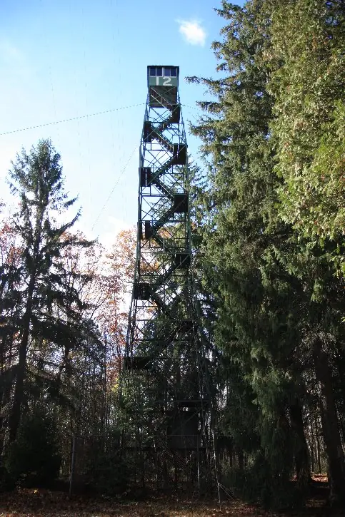
Photos keep their own rights and are shown with credit. Is one of these yours? You can ask for a different credit or for removal.
Sources
- Fire Towers of Pennsylvania (ArcGIS StoryMap, Shawn Lesitsky) (opens another site) Gave us: name, county, type, what it is built of, design, height, status, agency, ownership, dates, photos, links Pennsylvania fire towers StoryMap (ArcGIS) · No licence stated; facts only (county, agency, built year, height, builder). · retrieved 4 Oct 2026
- FOREST LOOKOUTS -- eastern US (easternuslookouts.weebly.com) (opens another site) Gave us: links easternuslookouts.weebly.com · No licence stated; facts only (county, coordinates where the page's own map widget gives them, status, height, design hints, register links). The site's own historical quotes, newspaper citations and narrative are not reproduced. · retrieved 8 Oct 2026
- OpenStreetMap -- fire lookout structures (opens another site) Gave us: location, elevation, links © OpenStreetMap contributors · ODbL 1.0. (c) OpenStreetMap contributors. · retrieved 4 Oct 2026
- Firefinder research Gave us: summary, agency, dates, links, fact-check Firefinder research (sources cited in the story footnotes) · Our own research notes; each fact cites its source in the lookout's story
More about this lookout elsewhere
- Firetower Road (onX Maps) (opens another site)
- Fire Towers of Pennsylvania StoryMap (Shawn Lesitsky) (opens another site)
- Hays Lot (easternuslookouts.weebly.com) (opens another site)
- OpenStreetMap node 357357589 (opens another site)
Firefinder takes facts (places, dates, numbers) from these sources and writes its own words. See all sources and licences.