Fire lookout · Huntingdon County, Pennsylvania
Jacks Mountain Firetower
Also known as Jacks Mountain (Butler Knob)
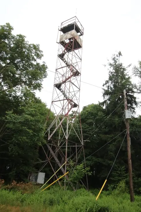
Huntingdon County, PA steel observation tower on Butler Knob, built 1922-23; staffed into the 1970s and now closed, with a weather station on the summit.
- Standing
- Closed
- Verified
Closed
The site is closed to visitors. Wikipedia describes the firetower on the summit as closed; the summit is reached by a rough road
Visit & stay
Not rentable. As far as we know, this lookout cannot be booked for overnight stays.
Access
Closed. See the warning at the top of this page.
- Can you climb it?
- No
- Road to the top?
- Yes, you can drive up
- Trail
- Rough road to the summit; views from a nearby scree slope. The tower is closed, so do not climb it.
- Staffing
- Staffed during fire season (as of 1972)
Facts
- Status
- Type
- Cab on a tower60-foot steel Blaw-Knox observation towerThe design: Blaw-Knox
- Built of
- SteelGoing by its design; no source says so in words.
- Built
- 1923
- Height
- 60 ft (18.3 m)
- Elevation
- 2,323 ft (708 m)
- Agency
- Rothrock State Forest
- Land
- State land
- Location
- Huntingdon County, Pennsylvania
- Coordinates
- 40.29315, −77.96655
- Registers
- Not on a lookout register
- This entry
- VerifiedResearched, then checked independently. Updated 9 Oct 2026.
- Firefinder id
us-pa-jacks-mountain
View from the cab
What you see from the cab: every ridge out to about 93 miles, the named peaks in sight, and other fire lookouts within view, worked out from terrain data in your browser.
Downloads about 3.1 MB of terrain data the first time.
Or see what it could see on the map: the ground in its line of sight.
History
Then and now
- 1923 BuiltCompleted spring 1923; construction began in 1922 per 1922 and 1926 reportsSource: easternuslookouts.weebly.com
- No record between 1923 and 1950
- 1950 StaffedC.G. Weirich named as towerman, December 1950Source: easternuslookouts.weebly.com
- No record between 1950 and 1972
- 1972 StaffedHarry Greenland named as tower operatorSource: easternuslookouts.weebly.com
- TodayStandingIt still stands, as far as our sources know.
Old maps of this spot
USGS topographic maps from the years a lookout stood may show it, often as a small symbol labelled “Lookout”. See the old topo maps around it on the Firefinder map, or find every scanned sheet of this spot on USGS TopoView (opens another site) (click the spot there to list them, with dates and downloads).
Story
Researched 9 Oct 2026, fact-checked.
The Jacks Mountain Fire Tower stands on Butler Knob, a peak on the Jacks Mountain ridge in Huntingdon County.1,2 The knob sits within Rothrock State Forest.2
Construction ran from 1922 into 1923, and the reports do not agree on the exact year.1 A Huntingdon paper described a 60-foot steel tower under construction in September 1922.1 A 1926 report says it was erected during 1922 by the Department of Forests and Waters.1 An April 1923 paper said it was about completed, and a 1972 article gives the spring of 1923 as its construction date.1 We date the finished tower to 1923.
The tower is a Blaw-Knox steel observation post, and in 1972 it was one of five towers in the Rothrock district.1
The tower was staffed by towermen.1 In December 1950 the Huntingdon Daily News named C.G. Weirich as the towerman at Jack's fire tower.1 A 1954 Huntingdon Daily News item called Charles G. Weirich of Mount Union an 80-year-old towerman, and reported nine inches of snow at the tower on November 3, 1954.1 In 1972 Harry Greenland of Three Springs was the tower operator.1
An undated Wikipedia article says a closed fire tower still stands on the summit.2 It also says the tower currently holds a weather station that gives forecasts for the area.2 The summit is reached by a rough road, and the article notes views from a nearby scree slope.2 Because the tower is closed, please do not climb it.
- Jacks Mountain, Forest Lookouts, https://easternuslookouts.weebly.com/jacks-mountain.html (accessed 2026-10-09). ↩
- Butler Knob, Wikipedia, https://en.wikipedia.org/wiki/Butler_Knob (accessed 2026-10-09). ↩
Photos
Photos keep their own rights and are shown with credit. Is one of these yours? You can ask for a different credit or for removal.
Sources
- Fire Towers of Pennsylvania (ArcGIS StoryMap, Shawn Lesitsky) (opens another site) Gave us: name, county, type, height, status, agency, ownership, dates, photos, links Pennsylvania fire towers StoryMap (ArcGIS) · No licence stated; facts only (county, agency, built year, height, builder). · retrieved 4 Oct 2026
- FOREST LOOKOUTS -- eastern US (easternuslookouts.weebly.com) (opens another site) Gave us: what it is built of, links easternuslookouts.weebly.com · No licence stated; facts only (county, coordinates where the page's own map widget gives them, status, height, design hints, register links). The site's own historical quotes, newspaper citations and narrative are not reproduced. · retrieved 8 Oct 2026
- OpenStreetMap -- fire lookout structures (opens another site) Gave us: location, elevation, links © OpenStreetMap contributors · ODbL 1.0. (c) OpenStreetMap contributors. · retrieved 4 Oct 2026
- Firefinder research Gave us: summary, design, height, agency, access, staffing, visiting details, dates, links, fact-check Firefinder research (sources cited in the story footnotes) · Our own research notes; each fact cites its source in the lookout's story
More about this lookout elsewhere
- Butler Knob (Wikipedia) (opens another site)
- Fire Towers of Pennsylvania StoryMap (Shawn Lesitsky) (opens another site)
- Jacks Mountain (Butler Knob) (easternuslookouts.weebly.com) (opens another site)
- OpenStreetMap node 357348541 (opens another site)
Firefinder takes facts (places, dates, numbers) from these sources and writes its own words. See all sources and licences.