Fire lookout · Somerset County, Pennsylvania
Mt. Davis
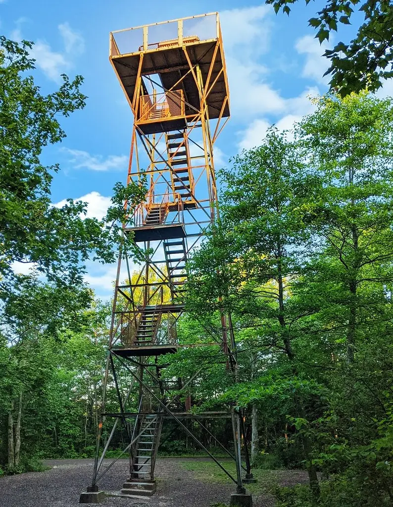
Pennsylvania's highest point has an observation tower dated 1935 (Willhite says 1934); recent sources describe it in the present tense, as in use or being fitted with signs.
- Standing
- Open to the public
- Verified
Visit & stay
Not rentable. As far as we know, this lookout cannot be booked for overnight stays.
Access
Open to the public. The storymap describes it as an observation tower used by the public. Willhite lists the road as paved and good gravel.
- Can you climb it?
- Unknown
- Road to the top?
- Yes, you can drive up
- Trail
- Short walk from the parking area, past a closed gate (Willhite). Climbing is unclear: a visitor guide urges it, while a state parks foundation article describes signage for visitors who cannot climb.
- Staffing
- Unknown
Facts
- Status
- Type
- Cab on a towerThe design: Blaw-Knox
- Built of
- Not recorded
- Built
- 1935
- Height
- 50 ft (15.2 m)
- Elevation
- Unknown
- Agency
- Forbes State Forest
- Land
- State land
- Location
- Somerset County, Pennsylvania
- Coordinates
- 39.78612, −79.17697
- Registers
- Not on a lookout register
- This entry
- VerifiedResearched, then checked independently. Updated 9 Oct 2026.
- Firefinder id
us-pa-mt-davis
View from the cab
What you see from the cab: every ridge out to about 93 miles, the named peaks in sight, and other fire lookouts within view, worked out from terrain data in your browser.
Downloads about 3.5 MB of terrain data the first time.
Or see what it could see on the map: the ground in its line of sight.
History
Then and now
- 1929 EventCommonwealth bought most of the state forest land around Mt. DavisSource: sites.google.com
- 1933 EventCCC camp S-97 established at Tub Mill Run; its listed projects include a Negro Mtn. fire towerSource: sites.google.com
- 1935 BuiltStorymap: built by Blaw-Knox Company, 50 ft. WPA: observation tower constructed on site in 1935. Willhite gives 1934 instead, erected by the state Department of Forests and Waters, likely with CCC help.Sources: arcgis.com, sites.google.com, willhiteweb.com
- 1945 EventMt. Davis declared a State Forest MonumentSource: sites.google.com
- No record between 1945 and 1974
- 1974 Event581 acres around the high point designated a State Forest Natural AreaSource: sites.google.com
- TodayStandingIt still stands, as far as our sources know.
Old maps of this spot
USGS topographic maps from the years a lookout stood may show it, often as a small symbol labelled “Lookout”. See the old topo maps around it on the Firefinder map, or find every scanned sheet of this spot on USGS TopoView (opens another site) (click the spot there to list them, with dates and downloads).
Story
Researched 9 Oct 2026, fact-checked.
Mt. Davis is the highest point in Pennsylvania, at 3,213 feet, and its observation tower stands on top of the mountain in Forbes State Forest, Somerset County.1,2,3,4
The date is disputed. The storymap and the WPA page both give 1935, and the storymap names the Blaw-Knox Company as builder.4,1 Willhite instead gives 1934, when the Department of Forests and Waters erected a forest fire observation tower, probably with help from the Civilian Conservation Corps.2 The WPA page lists a Negro Mtn. fire tower among the projects of a CCC camp set up in June 1933. It does not say this is the summit tower, though the names suggest it might be.1 Willhite also says the summit was called Negro Mountain at that time.2
Most of the state forest land around the mountain was bought by the Commonwealth in 1929.1 Mt. Davis was declared a State Forest Monument in 1945, and 581 acres around the high point became a State Forest Natural Area in 1974.1
The storymap gives the height as 50 feet and describes the tower as an observation tower for the public.4 The Pennsylvania Parks and Forests Foundation says the 1930s-era tower is getting new interpretive signs for visitors who cannot climb it.5 A visitor guide urges readers to climb the tower, and it describes a raised relief map and a plaque at the top.6
Willhite lists the road as paved and good gravel, and says the walk from the parking area is short, past a closed gate.2 The storymap and the foundation article both describe the tower in the present tense, as in use or being fitted with signs.4,5
The sources do not settle whether the tower can be climbed: the visitor guide urges it,6 while the foundation article describes signs aimed at visitors who cannot climb.5 Ask the state forest office before you go, and do not climb the tower if it is closed.
- Mt. Davis Area, Advocacy WPA, https://sites.google.com/view/advocacywpa/tourism/forests/forbes/mt-davis-area (accessed 2026-10-09). ↩
- Mount Davis the Pennsylvania Highpoint, WillhiteWeb.com, http://willhiteweb.com/state_highpoint/pennsylvania/mount_davis_137.htm (accessed 2026-10-09). ↩
- Mount Davis Natural Area, Wikipedia, https://en.wikipedia.org/wiki/Mount_Davis_Natural_Area (accessed 2026-10-09). ↩
- Fire Towers of Pennsylvania (story map data), ArcGIS StoryMaps, https://www.arcgis.com/sharing/rest/content/items/ed47c97ebe7246868ce8ef3e7139a0b4/data (accessed 2026-10-09). ↩
- Inside Forbes State Forest, Pennsylvania Parks and Forests Foundation, https://paparksandforests.org/think-outside/inside-forbes-state-forest-trails-history-and-hidden-wonders-with-ed-callahan-district-forester/ (accessed 2026-10-09). ↩
- Exploring Mount Davis - The Highest Point in Pennsylvania, PA Bucket List, https://pabucketlist.com/exploring-mount-davis-the-highest-point-in-pennsylvania/ (accessed 2026-10-09). ↩
Photos
Photos keep their own rights and are shown with credit. Is one of these yours? You can ask for a different credit or for removal.
Sources
- Fire Towers of Pennsylvania (ArcGIS StoryMap, Shawn Lesitsky) (opens another site) Gave us: name, location, county, type, height, status, agency, ownership, dates, photos, links Pennsylvania fire towers StoryMap (ArcGIS) · No licence stated; facts only (county, agency, built year, height, builder). · retrieved 4 Oct 2026
- Firefinder research Gave us: summary, height, status, agency, access, visiting details, dates, links, fact-check Firefinder research (sources cited in the story footnotes) · Our own research notes; each fact cites its source in the lookout's story
More about this lookout elsewhere
- Mt. Davis Area (Advocacy WPA (Google Sites)) (opens another site)
- Mount Davis the Pennsylvania Highpoint (WillhiteWeb.com) (opens another site)
- Mount Davis Natural Area (Wikipedia) (opens another site)
- Fire Towers of Pennsylvania (story map item data) (ArcGIS StoryMaps, Shawn Lesitsky) (opens another site)
- Inside Forbes State Forest: Trails, History, and Hidden Wonders with Ed Callahan (Pennsylvania Parks and Forests Foundation) (opens another site)
- Exploring Mount Davis - The Highest Point in Pennsylvania (PA Bucket List) (opens another site)
- Fire Towers of Pennsylvania StoryMap (Shawn Lesitsky) (opens another site)
Firefinder takes facts (places, dates, numbers) from these sources and writes its own words. See all sources and licences.