Fire lookout · Abbeville County, South Carolina
Parsons Mountain Lookout
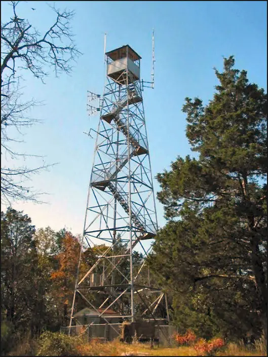
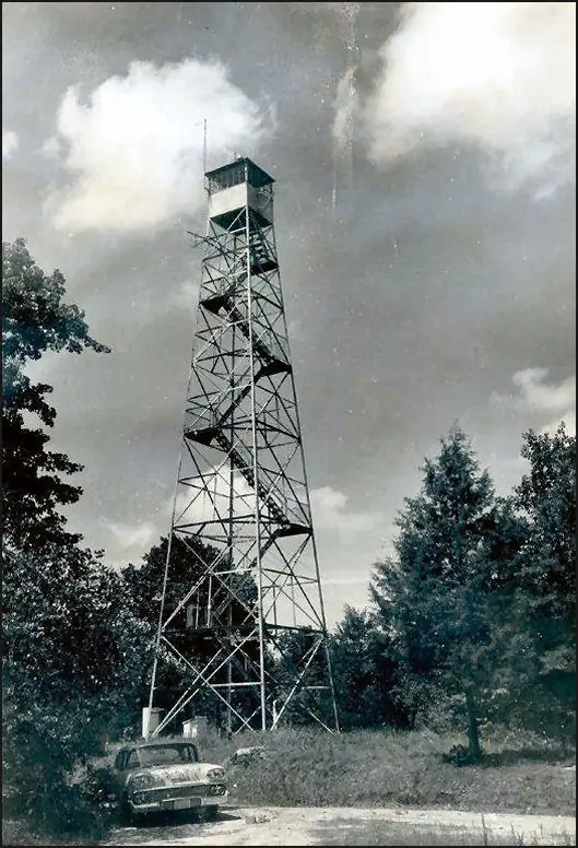
73-foot Forest Service lookout on Parsons Mountain near Abbeville, SC; built 1935, used until 1989; fenced and posted no trespassing at a 2020 visit.
- Standing
- Closed
- Verified
Closed
The site is closed to visitors. The 2020 Register visit found no access and no-trespassing signs. The Forest Service trail page describes a hike up the Tower trail to the tower.
Visit & stay
Not rentable. As far as we know, this lookout cannot be booked for overnight stays.
Access
Closed. See the warning at the top of this page.
- Can you climb it?
- No
- Road to the top?
- Unknown
- Trail
- Forest Service describes a hiking trail to the tower; the 2020 Register visit found the tower fenced and signed no trespassing.
- Staffing
- Not staffed (as of 2020)
Facts
- Status
- Type
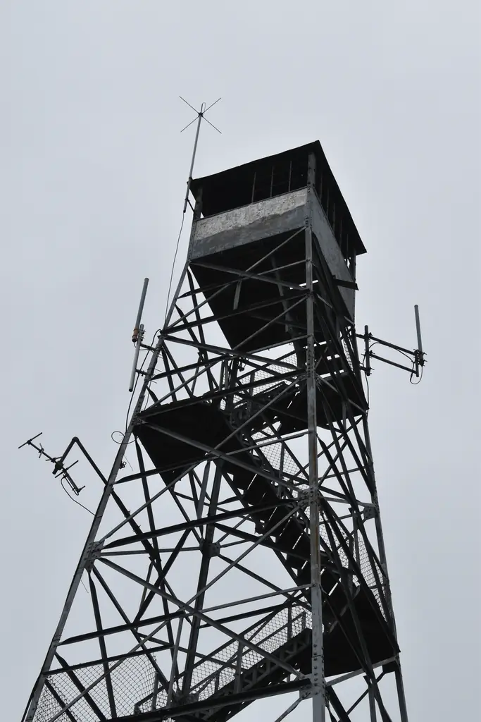
- Cab on a tower73-foot LS-40 Aermotor tower with 7x7-foot galvanized metal cab and hip roofThe design: Aermotor LS-40
- Built of
- Not recorded
- Built
- 1935
- Height
- 73 ft (22.3 m)
- Elevation
- 824 ft (251 m)
- Agency
- U.S. Forest Service
- Land
- Federal land
- Location
- Abbeville County, South Carolina
- Coordinates
- 34.08306, −82.36278 sources disagree
- Registers
- This entry
- VerifiedResearched, then checked independently. Updated 8 Oct 2026.
- Firefinder id
us-sc-parsons-mountain
View from the cab
What you see from the cab: every ridge out to about 93 miles, the named peaks in sight, and other fire lookouts within view, worked out from terrain data in your browser.
Downloads about 2.9 MB of terrain data the first time.
Or see what it could see on the map: the ground in its line of sight.
History
Then and now
- 1935 BuiltRegister: constructed November 1935Source: nhlr.org
- 1936 First staffedApril 1936 newspaper report: lookouts stationed on the towerSource: easternuslookouts.weebly.com
- No record between 1936 and 1973
- 1973 EventForest Service closed the tower road to motor vehicles, citing vandalism (May 1973 announcement)Source: easternuslookouts.weebly.com
- No record between 1973 and 1989
- 1989 Last staffedRegister: used by the Forest Service actively until 1989Source: nhlr.org
- No record between 1989 and 2009
- 2009 Added to the National Historic Lookout RegisterRegistered November 17, 2009 as US 837, SC 7Source: nhlr.org
- 2020 Condition assessmentNHLR volunteer visit, September 16, 2020Source: nhlr.org
- TodayStandingIt still stands, as far as our sources know.
Old maps of this spot
USGS topographic maps from the years a lookout stood may show it, often as a small symbol labelled “Lookout”. See the old topo maps around it on the Firefinder map, or find every scanned sheet of this spot on USGS TopoView (opens another site) (click the spot there to list them, with dates and downloads).
Story
Researched 9 Oct 2026, fact-checked.
Parsons Mountain sits south of Abbeville, South Carolina, in the Long Cane district of the Sumter National Forest.1,2 A February 1936 newspaper report and a 1939 guide disagree on the distance to town: the newspaper puts the mountain about seven miles south of Abbeville, and the guide says six.2
The National Historic Lookout Register says the lookout was constructed in November 1935.1 It describes a 73-foot LS-40 Aermotor tower with a 7-by-7-foot galvanized metal cab and a hip roof, administered by the U.S. Forest Service.1 A 1935 newspaper report, as reproduced by a lookout history site, called it the third steel lookout the Forest Service was building in the Long Cane district.2
Who built it is less clear. The newspapers name the Forest Service, while a historical marker in Abbeville says the Civilian Conservation Corps built the fire tower in 1935.2,3 The sources do not settle the question.
By April 1936 a newspaper reported that lookouts were stationed on the tower and that three steel lookout towers were manned during all daylight hours.2 The Register says the Forest Service used the lookout actively until 1989.1 In May 1973 the district announced that the tower road was closed to motor vehicles. The announcement blamed vandalism and said the tower was broken into almost every year.2
When a volunteer visited in September 2020, the cab's windows were broken, but the structure and stairs were in good condition. The visit form asked whether the site was staffed, and the answer recorded was no.1 The visitor saw that the fence around the base had been pulled down to get in, and recorded that there was no access and that the tower carried no-trespassing signs.1
The Forest Service's trail page invites hikers up the Tower trail to the historic fire tower.4 The same page carries a current-conditions note that all recreation sites on the forest remain closed after Hurricane Helene until conditions improve.4 Treat the tower itself as off limits, and check with the Long Cane district before any trip.
- Parsons Mountain Lookout, National Historic Lookout Register (nhlr.org), http://nhlr.org/lookouts/us/sc/parsons-mountain-lookout/ (accessed 2026-10-09). ↩
- Parsons Mountain - Forest Lookouts (easternuslookouts.weebly.com), https://easternuslookouts.weebly.com/parsons-mountain.html (accessed 2026-10-09). ↩
- Parsons Mountain Historical Marker, Historical Marker Database (hmdb.org), https://www.hmdb.org/m.asp?m=43727 (accessed 2026-10-09). ↩
- Parson's Mountain Lake and Tower Trails, Francis Marion and Sumter National Forests, U.S. Forest Service, https://www.fs.usda.gov/r08/francismarionsumter/recreation/trails/parsons-mountain-lake-and-tower-trails (accessed 2026-10-09). ↩
Photos
Photos keep their own rights and are shown with credit. Is one of these yours? You can ask for a different credit or for removal.
Where sources disagree
We show disagreements between sources instead of quietly picking one. If you know which is right, please tell us.
Sources disagree on the location by 2.1 km (1.3 mi).
- NHLR: 34.08306, −82.36278
- FOREST LOOKOUTS -- eastern US (easternuslookouts.weebly.com): 34.10012, −82.35429
The map uses the position from NHLR.
Sources
- National Historic Lookout Register (NHLR) (opens another site) Gave us: name, location, county, elevation, status, register numbers, agency, ownership, dates, photos, links National Historic Lookout Register (nhlr.org) · All rights reserved (American Resources, Inc.); facts extracted only, no prose copied. · retrieved 4 Oct 2026
- FOREST LOOKOUTS -- eastern US (easternuslookouts.weebly.com) (opens another site) Gave us: type, links easternuslookouts.weebly.com · No licence stated; facts only (county, coordinates where the page's own map widget gives them, status, height, design hints, register links). The site's own historical quotes, newspaper citations and narrative are not reproduced. · retrieved 8 Oct 2026
- Firefinder research Gave us: summary, design, height, agency, access, staffing, visiting details, dates, links, fact-check Firefinder research (sources cited in the story footnotes) · Our own research notes; each fact cites its source in the lookout's story
More about this lookout elsewhere
- NHLR register entry US 837 (nhlr.org) (opens another site)
- NHLR register entry (nhlr.org) (opens another site)
- Parsons Mountain Historical Marker (Historical Marker Database (hmdb.org)) (opens another site)
- Parson's Mountain Lake and Tower Trails (Francis Marion and Sumter National Forests, U.S. Forest Service) (opens another site)
- Parson's Mountain (easternuslookouts.weebly.com) (opens another site)
Firefinder takes facts (places, dates, numbers) from these sources and writes its own words. See all sources and licences.