Fire lookout · Pennington County, South Dakota
Flag Mountain Lookout Site
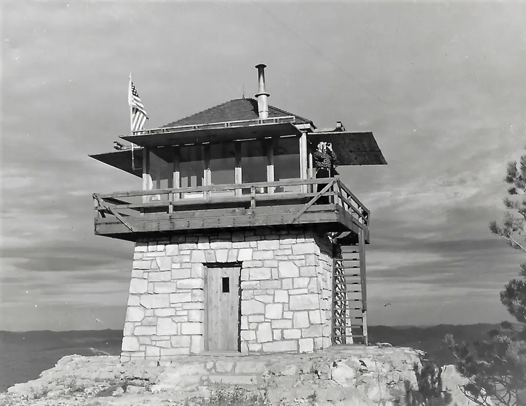
Pennington County lookout built 1940 on Flag Mountain by CCC labor; register says removed 1975, cab gone, a stone or concrete base remains; sources disagree on build year and 1951 abandonment.
- Gone
- Open to the public
- Verified
Gone: The lookout no longer stands. Only the site is left. Cab gone; part of the base remains. The register gives 1975 as the removal year.
Visit & stay
Gone: site only. The lookout no longer stands, so there is nothing to climb or rent. You may still be able to visit the site.
Access
Open to the public. On Black Hills National Forest land; reached by Forest Service Road 189.2 and a short walk, per a hiking blog and an onX trail page
- Road to the top?
- Yes, you can drive up
- Trail
- A hiking blog describes a rough one-way road about a mile to the top, a short climb of stairs from the parking area, and says the Flag Mountain Lookout Road does not reach the top
Facts
- Status
- Type
- Two-story building10-foot stone base with L-4 cabThe design: L-4
- Built of
- Not recorded
- Built
- 1940
- Height
- 14 ft (4.3 m)
- Elevation
- 6,940 ft (2,115 m)
- Agency
- U.S. Forest Service, Black Hills National Forest
- Land
- Federal land
- Location
- Pennington County, South Dakota
- Coordinates
- 44.07071, −103.82679
- Registers
- This entry
- VerifiedResearched, then checked independently. Updated 9 Oct 2026.
- Firefinder id
us-sd-flag-mountain
View from the cab
What the lookout saw from its cab: every ridge out to about 93 miles, the named peaks in sight, and other fire lookouts within view, worked out from terrain data in your browser.
This lookout is gone. The view is reconstructed from its recorded site and its recorded height.
Downloads about 3.9 MB of terrain data the first time.
Or see what it could see on the map: the ground in its line of sight.
History
Then and now
- 1940 BuiltFirelookout and Forest Lookouts give 1940; the register gives 1940-1941 and a hiking blog and onX give 1941Sources: firelookout.com, westlookouts.weebly.com
- 1942 StaffedDan Weirs listed as lookoutSource: firelookout.com
- 1951 AbandonedClaimed by a Black Hills ATV travel site; staffing lists in the other sources run past 1951Source: blackhillsatvdestinations.com
- 1952 StaffedWilliam A. Reman began duties April 28, 1952 per Forest Lookouts; firelookout lists him in 1951Sources: westlookouts.weebly.com, firelookout.com
- 1963 StaffedClaire Marvin listed, served multiple yearsSource: firelookout.com
- 1975 RemovedRegister Removed fieldSource: firetower.org
- No record between 1975 and 2026
- 2026 Added to the Former Fire Lookout Sites RegisterRegistered January 2, 2026, nominated by Dixie BoyleSource: firetower.org
- TodayGoneThe lookout no longer stands. Only the site is left.
Old maps of this spot
USGS topographic maps from the years a lookout stood may show it, often as a small symbol labelled “Lookout”. See the old topo maps around it on the Firefinder map, or find every scanned sheet of this spot on USGS TopoView (opens another site) (click the spot there to list them, with dates and downloads).
Story
Researched 9 Oct 2026, fact-checked.
Flag Mountain stands west of Deerfield, in Pennington County, on Black Hills National Forest land.1 The name goes back to 1876, when Joe Reynolds, a former scout for General Custer, put a flag on the peak to warn nearby settlers of a threatened uprising. His sons kept up the custom until a lookout was completed.1
The forest supervisor announced in June 1940 that a 14-by-14-foot lookout on a 10-foot base would be finished by fall.2 By November the station was complete, and the Roubaix CCC camp did the work.2 Other sources date the build to 1941, so the year is not settled.1,3,4
The lookouts named in the sources include Dan Weirs in 1942, Frank Kaump in 1944, Jack Munson in 1946, and Lyle Hamm in 1957.5 Claire Marvin is listed for 1963 and is noted as serving several years.5 Forest Lookouts says William A. Reman started at the lookout in April 1952, while the firelookout page lists him in 1951.2,5
The register gives 1975 as the year the lookout was removed.1 A Black Hills travel site says it was abandoned in 1951, but the staffing lists in other sources run past that date.6,5 The firelookout page says the cab is gone and parts of the stone base remain.5 Forest Lookouts says what is left is the lower rock wall of the base, and a log outhouse sits a short walk away.2
A hiking blog says only a concrete base is left on top, along with a wooden bathroom on the hill's north side.3 It says a short set of stairs from the parking area leads up to the tower, and warns that the Flag Mountain Lookout Road does not reach the top.3 An onX trail page describes a route that starts near the summit on Forest Service Road 189.2, and says the concrete base is still visible.4 The sources do not agree on whether the base is stone or concrete.5,3
- Flag Mountain Lookout Site, Former Fire Lookout Sites register, http://firetower.org/lookouts/us/sd/flag-mountain-lookout-site/ (accessed 2026-10-09). ↩
- Flag Mountain, Forest Lookouts, https://westlookouts.weebly.com/flag-mountain.html (accessed 2026-10-09). ↩
- Flag Mountain Lookout/Fire Tower, Black Hills Hiking, Biking, and More, https://www.blackhillshikingbikingandmore.com/flag-mountain-lookoutfire-tower (accessed 2026-10-09). ↩
- Flag Mountain - FS 189.2, onX Maps, https://www.onxmaps.com/offroad/trails/us/south-dakota/flag-mountain-fs-1892-e7qego472z1y (accessed 2026-10-09). ↩
- Flag Mtn. Fire Lookout Tower, Forest Fire Lookout Association, https://www.firelookout.com/sd/flagmtn.html (accessed 2026-10-09). ↩
- Flag Mountain Fire Tower, Black Hills ATV Destinations, https://blackhillsatvdestinations.com/flag-mountain-fire-tower/ (accessed 2026-10-09). ↩
Photos
Photos keep their own rights and are shown with credit. Is one of these yours? You can ask for a different credit or for removal.
Sources
- Former Fire Lookout Sites Register (FFLOS) (opens another site) Gave us: name, location, county, elevation, register numbers, agency, ownership, dates, photos, links Former Fire Lookout Sites Register (firetower.org) · All rights reserved (American Resources, Inc.); facts extracted only, no prose copied. · retrieved 4 Oct 2026
- Forest Fire Lookout Association (FFLA) - US lookout lists (opens another site) Gave us: type, status, register numbers, links Forest Fire Lookout Association (firelookout.org) · No licence stated; facts extracted only, no prose copied. · retrieved 8 Oct 2026
- firelookout.com -- Rex Kamstra's Forest Fire Lookout Page (opens another site) Gave us: links firelookout.com · No licence stated on the site; facts only (coordinates, elevation, built/destroyed years, design, agency). Photos mirrored with the site's stated credit. · retrieved 4 Oct 2026
- FOREST LOOKOUTS -- western US (Ron Kemnow's weebly sites) (opens another site) Gave us: height, links Ron Kemnow's Forest Lookouts sites (westlookouts, californialookouts, idaholookouts, montanalookouts, oregonlookouts and washingtonlookouts .weebly.com) · No licence stated; facts only (county, land manager, status word, coordinates where the page's own map widget gives them, township-range-section, height and design hints, links). The site's own newspaper quotes, citations and narrative are not reproduced. · retrieved 8 Oct 2026
- Firefinder research Gave us: summary, design, status, agency, access, visiting details, dates, links, fact-check Firefinder research (sources cited in the story footnotes) · Our own research notes; each fact cites its source in the lookout's story
More about this lookout elsewhere
- FFLOS register entry US 2122 (firetower.org) (opens another site)
- Flag Mountain Lookout/Fire Tower (Black Hills Hiking, Biking, and More) (opens another site)
- Flag Mountain Fire Tower (Black Hills ATV Destinations) (opens another site)
- Flag Mountain - FS 189.2 (onX Maps) (opens another site)
- FFLA South Dakota lookout list (firelookout.org) (opens another site)
- Flag Mtn. on firelookout.com (Rex Kamstra) (opens another site)
- Flag Mountain on Forest Lookouts, western US (Ron Kemnow) (opens another site)
Firefinder takes facts (places, dates, numbers) from these sources and writes its own words. See all sources and licences.