Fire lookout · Cherokee County, Texas
Love's Lookout
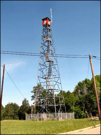
A 1935 Texas Forest Service fire tower on a ridge named for Wesley Love, now standing but closed to climbers in a Jacksonville city park.
- Standing
- Open to the public
- Verified
Visit & stay
Not rentable. As far as we know, this lookout cannot be booked for overnight stays.
Access
Open to the public. Public city park; the tower itself is not open to climb.
- Can you climb it?
- No
- Road to the top?
- Yes, you can drive up
- Staffing
- Not staffed
Facts
- Status
- Type
- Cab on a tower125-ft steel Aermotor tower with a 7x7 ft metal cabThe design: Aermotor
- Built of
- SteelGoing by its design; no source says so in words.
- Built
- 1935
- Height
- 125 ft (38.1 m)
- Elevation
- 703 ft (214 m)
- Agency
- City of Jacksonville, Texas
- Land
- Unknown
- Location
- Cherokee County, Texas
- Coordinates
- 32.03019, −95.28064
- Registers
- This entry
- VerifiedResearched, then checked independently. Updated 8 Oct 2026.
- Firefinder id
us-tx-loves
View from the cab
What you see from the cab: every ridge out to about 93 miles, the named peaks in sight, and other fire lookouts within view, worked out from terrain data in your browser.
Downloads about 3.0 MB of terrain data the first time.
Or see what it could see on the map: the ground in its line of sight.
History
Then and now
- 1935 BuiltTexas Forest Service built a 125-ft steel Aermotor tower with a 7x7 ft metal cabSource: nhlr.org
- No record between 1935 and 1970
- 1970 Last staffedNHLR entry says the tower remained active until 1970Source: nhlr.org
- 1980 Last staffedTexas Escapes says the tower instead functioned into the 1980s until fire-spotting planes made it obsolete; conflicts with NHLR's 1970 date, year approximateSource: texasescapes.com
- No record between 1980 and 1996
- 1996 Added to the National Historic Lookout RegisterDate registered per NHLR detail page: May 30, 1996Source: NHLR register entry
- TodayStandingIt still stands, as far as our sources know.
Old maps of this spot
USGS topographic maps from the years a lookout stood may show it, often as a small symbol labelled “Lookout”. See the old topo maps around it on the Firefinder map, or find every scanned sheet of this spot on USGS TopoView (opens another site) (click the spot there to list them, with dates and downloads).
Story
Researched 4 Oct 2026, fact-checked.
Love's Lookout takes its name from Wesley Love, a Jacksonville resident who bought much of this ridge in 1904 and planted a 600-acre peach orchard on it.1 After Love died in 1925, his widow gave 22 acres of the property to the state of Texas, hoping it would become a state park, but the state never built one.1 In 1934 the City of Jacksonville bought another 20 acres alongside Love's donated land and combined the two tracts into a city park.1 Workers from the federal Works Progress Administration then built out the site, adding picnic grounds, a stone amphitheater used for sunrise services and other events, a swimming pool, and a dance pavilion, much of it faced in local Cherokee County red rock.1
The fire tower came soon after. The Texas Forest Service put up a 125-foot steel Aermotor tower topped with a 7-by-7-foot metal cab in 1935.2 It watched over the East Texas pineywoods, part of a network that once numbered more than a hundred such towers across the region keeping lookout for wildfire.2 The National Historic Lookout Register's own entry says the tower stayed in service until 1970;2 a Texas Escapes history of the site instead says it kept working into the 1980s, until spotter planes made ground-based lookouts unnecessary.1 The two accounts do not agree on when the tower's fire-watching days ended.
The tower still stands on the hilltop today, owned by the City of Jacksonville, and the ridge remains a public park.2,1 It was entered into the National Historic Lookout Register on May 30, 1996, nominated by the Texas Forest Service's Henderson office, and was the first Texas lookout on that register.2 The structure itself is no longer open to climb,1 so visitors see it from the ground, alongside the park's other WPA-era stonework and the long view out over the pines that first drew people to the hill.
- Love's Lookout in Texas, Texas Escapes (texasescapes.com), https://www.texasescapes.com/AllThingsHistorical/Loves-Lookout-504BB.htm (accessed 2026-10-04). ↩
- Love's Lookout, National Historic Lookout Register (nhlr.org), http://nhlr.org/lookouts/us/tx/loves-lookout/ (accessed 2026-10-04). ↩
Photos
Photos keep their own rights and are shown with credit. Is one of these yours? You can ask for a different credit or for removal.
Sources
- National Historic Lookout Register (NHLR) (opens another site) Gave us: name, location, county, elevation, what it is built of, register numbers, agency, dates, photos, links National Historic Lookout Register (nhlr.org) · All rights reserved (American Resources, Inc.); facts extracted only, no prose copied. · retrieved 4 Oct 2026
- Forest Fire Lookout Association (FFLA) - US lookout lists (opens another site) Gave us: type, status, register numbers, links Forest Fire Lookout Association (firelookout.org) · No licence stated; facts extracted only, no prose copied. · retrieved 8 Oct 2026
- FOREST LOOKOUTS -- central US (centraluslookouts.weebly.com) (opens another site) Gave us: height, links centraluslookouts.weebly.com · No licence stated; facts only (county, coordinates where the page's own map widget gives them, status, height, design hints, register links). The site's own historical quotes, newspaper citations and narrative are not reproduced. · retrieved 8 Oct 2026
- Firefinder research Gave us: summary, design, height, status, access, staffing, visiting details, dates, links, fact-check Firefinder research (sources cited in the story footnotes) · Our own research notes; each fact cites its source in the lookout's story
More about this lookout elsewhere
- NHLR register entry US 168 (nhlr.org) (opens another site)
- NHLR register entry (nhlr.org) (opens another site)
- Love's Lookout in Texas (Texas Escapes (texasescapes.com)) (opens another site)
- FFLA Texas lookout list (firelookout.org) (opens another site)
- Love's (centraluslookouts.weebly.com) (opens another site)
Firefinder takes facts (places, dates, numbers) from these sources and writes its own words. See all sources and licences.