Fire lookout · Henrico County, Virginia
Meadows Fire Tower
Also known as Meadows (Lower Henrico)
Early-1930s Aermotor fire tower in Henrico County, Virginia; NHLR-registered 2021; last listed standing, condition after 2021 unconfirmed; county marker 2024.
- Standing
- Access unknown
- Verified
Visit & stay
Not rentable. As far as we know, this lookout cannot be booked for overnight stays.
Access
Access unknown
We do not know the access rules. Check with the land manager before you go.
- Can you climb it?
- Unknown
- Road to the top?
- Unknown
- Staffing
- Unknown
Facts
- Status
- Type
- Cab on a towerAermotor tower, 100 ft (30.5 m), modular galvanized steel kit with a 7 by 7 ft cabThe design: Aermotor
- Built of
- SteelGoing by its design; no source says so in words.
- Built
- 1930
- Height
- 100 ft (30.5 m)
- Elevation
- 158 ft (48 m)
- Agency
- Virginia Department of Forestry
- Land
- Unknown
- Location
- Henrico County, Virginia
- Coordinates
- 37.51060, −77.23879 sources disagree
- Registers
- This entry
- VerifiedResearched, then checked independently. Updated 8 Oct 2026.
- Firefinder id
us-va-meadows
View from the cab
What you see from the cab: every ridge out to about 93 miles, the named peaks in sight, and other fire lookouts within view, worked out from terrain data in your browser.
Downloads about 3.3 MB of terrain data the first time.
Or see what it could see on the map: the ground in its line of sight.
History
Then and now
- 1930 BuiltCounty says built in the early 1930s, one of two Henrico towers; 1930 is a placeholder year, no exact year in our sourcesSource: henrico.gov
- 1941 Condition assessmentU.S. Coast and Geodetic Survey station description: about 110 ft, four-legged steel, glass-enclosed cab, owned and operated by the Virginia Department of ConservationSource: easternuslookouts.weebly.com
- No record between 1941 and 1990
- 1990 Last staffedCounty says the tower served as a fire lookout until the 1990s; 1990 is a placeholder for that decade, not a documented dateSource: henrico.gov
- No record between 1990 and 2015
- 2015 EventAugust 2015: placed up for bids in a government auction, listed in scrap conditionSource: easternuslookouts.weebly.com
- 2021 Added to the National Historic Lookout RegisterRegistered January 8, 2021 as US 1489, VA 43Source: nhlr.org
- 2024 EventHistorical marker erected by the County of Henrico on Elko Road, south of US 60Source: hmdb.org
- TodayStandingIt still stands, as far as our sources know.
Old maps of this spot
USGS topographic maps from the years a lookout stood may show it, often as a small symbol labelled “Lookout”. See the old topo maps around it on the Firefinder map, or find every scanned sheet of this spot on USGS TopoView (opens another site) (click the spot there to list them, with dates and downloads).
Story
Researched 8 Oct 2026, fact-checked.
Henrico County counts the Meadows Tower, also called the Lower Henrico Tower, as one of two fire towers it put up in the early 1930s.1 Chicago's Aeromotor Company produced the galvanized parts as a kit that could be built to several preset heights, and U.S. Forest Service crews, usually five or six men, assembled them on site.1 The Forest Lookouts page calls it an Aermotor tower.2 The county gives its height as one hundred feet and its cab as seven by seven feet, with eight windows.1
During fire season, watchers, many of them women, went up the tower twice a day to scan the area.1 Watchers located blazes with an alidade and reported them by radio to the Forest Service office.1 The sources we read name no particular fire this tower helped to fight.
The measurements disagree. The county and the Forest Lookouts page say 100 feet, while the National Historic Lookout Register says about 110 feet.1,2,3 A 1941 U.S. Coast and Geodetic Survey station description, which appears on the Forest Lookouts page, also gives about 110 feet and says the Virginia Department of Conservation owned and ran the tower.2
The county says the tower was in use as a lookout until the 1990s, and that its sister tower in the West End was torn down in the late 1980s.1 In August 2015, according to the Forest Lookouts page, the 100-foot tower was offered at a government auction, with a listing that gave its condition as scrap.2 The Register lists it as US 1489, VA 43, registered on January 8, 2021, and says it sits just off US 60.3 The Forest Fire Lookout Association's Virginia list marks it as standing.4
In 2024 Henrico County put up a historical marker on Elko Road, south of Williamsburg Road (US 60).5 The marker places the tower site across Route 60, just east of Meadow Road, and says the lookout served until the 1990s.1,5 We found no source that confirms the tower's condition, owner, or public access after 2021, so its standing today remains unconfirmed. Visitors should check with the Virginia Department of Forestry or Henrico County before going, and should not climb any remaining structure.
- Meadows Fire Tower, Henrico County Government (henrico.gov), https://henrico.gov/locations/meadows-fire-tower/ (accessed 2026-10-08). ↩
- Meadows (Lower Henrico), Forest Lookouts (easternuslookouts.weebly.com), https://easternuslookouts.weebly.com/meadows.html (accessed 2026-10-08). ↩
- Meadows Fire Tower, National Historic Lookout Register (nhlr.org), http://nhlr.org/lookouts/us/va/meadows-fire-tower/ (accessed 2026-10-08). ↩
- Lookouts in Virginia, Forest Fire Lookout Association (firelookout.org), https://firelookout.org/lookouts/us/va/ (accessed 2026-10-08). ↩
- Meadows Fire Tower Historical Marker, Historical Marker Database (hmdb.org), https://www.hmdb.org/m.asp?m=239310 (accessed 2026-10-08). ↩
Photos
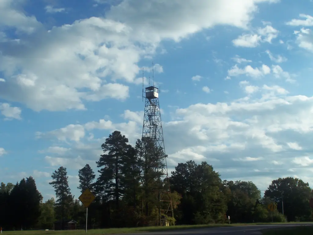
Photos keep their own rights and are shown with credit. Is one of these yours? You can ask for a different credit or for removal.
Where sources disagree
We show disagreements between sources instead of quietly picking one. If you know which is right, please tell us.
Sources disagree on the location by 2.7 km (1.7 mi).
- NHLR: 37.51060, −77.23879
- FOREST LOOKOUTS -- eastern US (easternuslookouts.weebly.com): 37.50650, −77.26910
The map uses the position from NHLR.
Sources
- National Historic Lookout Register (NHLR) (opens another site) Gave us: name, location, county, elevation, register numbers, agency, dates, photos, links National Historic Lookout Register (nhlr.org) · All rights reserved (American Resources, Inc.); facts extracted only, no prose copied. · retrieved 4 Oct 2026
- Forest Fire Lookout Association (FFLA) - US lookout lists (opens another site) Gave us: type, status, register numbers, links Forest Fire Lookout Association (firelookout.org) · No licence stated; facts extracted only, no prose copied. · retrieved 8 Oct 2026
- FOREST LOOKOUTS -- eastern US (easternuslookouts.weebly.com) (opens another site) Gave us: what it is built of, design, height, links easternuslookouts.weebly.com · No licence stated; facts only (county, coordinates where the page's own map widget gives them, status, height, design hints, register links). The site's own historical quotes, newspaper citations and narrative are not reproduced. · retrieved 8 Oct 2026
- Firefinder research Gave us: summary, design, height, status, agency, dates, links, fact-check Firefinder research (sources cited in the story footnotes) · Our own research notes; each fact cites its source in the lookout's story
More about this lookout elsewhere
- NHLR register entry US 1489 (nhlr.org) (opens another site)
- Meadows Fire Tower (Henrico County Government (henrico.gov)) (opens another site)
- Meadows Fire Tower Historical Marker (Historical Marker Database (hmdb.org)) (opens another site)
- FFLA Virginia lookout list (firelookout.org) (opens another site)
- Meadows (lower henrico) (easternuslookouts.weebly.com) (opens another site)
Firefinder takes facts (places, dates, numbers) from these sources and writes its own words. See all sources and licences.