Fire lookout · Windham County, Vermont
Stratton Mountain Lookout
Also known as Stratton Fire Tower
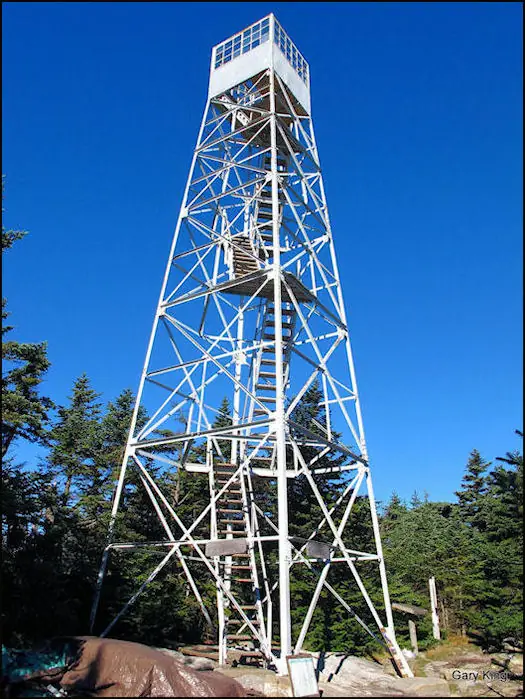
A 1934 CCC-built 55-ft Aermotor fire tower on Stratton Mountain, Vermont, on the Appalachian Trail; fire spotting ended in 1982 and it is now open to climbers.
- Standing
- Open to the public
- Verified
Visit & stay
Not rentable. As far as we know, this lookout cannot be booked for overnight stays.
Access
Open to the public. USFS says visitors may climb the renovated tower; the summit lies on the Appalachian and Long Trails. Current tower condition and any climbing rules were not verified on site.
- Can you climb it?
- Yes
- Road to the top?
- Unknown
- Trail
- White-blazed Appalachian and Long Trail from a parking area; about 1.4 miles to a forest road crossing, then the steeper climb to the summit.
- Staffing
- Unknown
Facts
- Status
- sources disagree
- Type
- Cab on a tower55-ft Aermotor steel tower with 7x7-ft cab (register and Green Mountain Club shelter history); USFS calls the renovated tower 70 ftThe design: Aermotor
- Built of
- SteelGoing by its design; no source says so in words.
- Built
- 1914
- Height
- 55 ft (16.8 m)
- Elevation
- 3,927 ft (1,197 m)
- Agency
- U.S. Forest Service (Green Mountain National Forest)
- Land
- Federal land
- Location
- Windham County, Vermont
- Coordinates
- 43.08599, −72.92485 sources disagree
- Registers
- This entry
- VerifiedResearched, then checked independently. Updated 8 Oct 2026.
- Firefinder id
us-vt-stratton-mountain
View from the cab
What you see from the cab: every ridge out to about 93 miles, the named peaks in sight, and other fire lookouts within view, worked out from terrain data in your browser.
Downloads about 3.7 MB of terrain data the first time.
Or see what it could see on the map: the ground in its line of sight.
History
Then and now
- 1914 BuiltBuilt by the Stratton Mountain Club with the Vermont State Forester; 60-ft steel tower per register and Green Mountain Club shelter history, 65-ft per nominationSources: nhlr.org, npgallery.nps.gov, gmcburlington.org
- 1920 DestroyedPartly destroyed in a winter storm in 1920-21; remains continued in serviceSource: gmcburlington.org
- 1928 BuiltWatchman's cabin; nomination says probably built by sawmill owner Leon Stocker, GMC shelter history says built by the Vermont Timber Owners' Association and state forestry departmentSources: nhlr.org, npgallery.nps.gov, gmcburlington.org
- 1934 BuiltCCC built the present 55-ft Aermotor tower with 7x7-ft cabSources: nhlr.org, npgallery.nps.gov, gmcburlington.org
- 1936 RemovedOld 1914 tower razedSource: gmcburlington.org
- No record between 1936 and 1970
- 1970 BuiltState of Vermont built a larger prefabricated log cabin on the summitSources: nhlr.org, npgallery.nps.gov, gmcburlington.org
- 1982 Last staffedFire spotting ended after the 1982 season; one of the last three Vermont towers used for fire spottingSource: npgallery.nps.gov
- 1986 EventForest Service acquired a large tract including the south summit (nomination)Source: npgallery.nps.gov
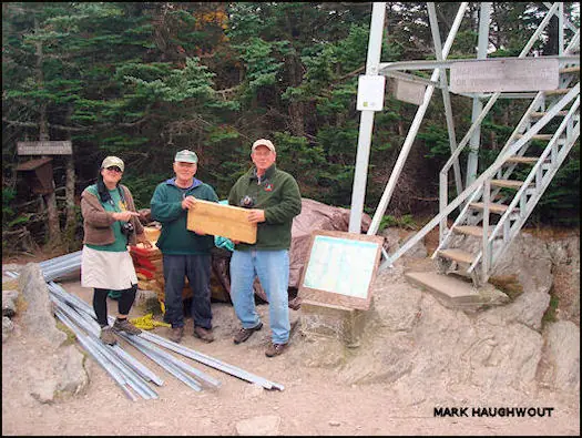
- 1988 RestoredTower repaired and painted to serve for recreational viewingSource: npgallery.nps.gov
- 1989 EventLog cabin reopened to provide quarters for a residentSource: npgallery.nps.gov
- 1990 EventRegister says the land and tower were purchased by the USFS in 1990Source: nhlr.org
- 1992 Added to the National Historic Lookout RegisterRegistered August 2, 1992 as US 48, VT 1Source: nhlr.org
- 1992 Listed on the National Register of Historic PlacesListed on the National Register of Historic Places in 1992Source: gmcburlington.org
- No record between 1992 and 2010
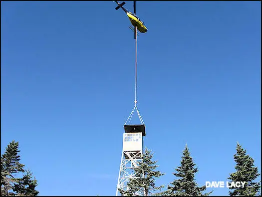
- 2010 RestoredNew one-piece roof was flown onto the tower by helicopter (airlift moved to 13 October) in a joint effort of the US Forest Service and Green Mountain Club.Source: firelookout.org
- TodayStandingIt still stands, as far as our sources know.
Old maps of this spot
USGS topographic maps from the years a lookout stood may show it, often as a small symbol labelled “Lookout”. See the old topo maps around it on the Firefinder map, or find every scanned sheet of this spot on USGS TopoView (opens another site) (click the spot there to list them, with dates and downloads).
Story
Researched 8 Oct 2026, fact-checked.
The first lookout on Stratton Mountain went up in the spring of 1914, when the Stratton Mountain Club, working with the Vermont State Forester, put a steel tower on the summit.1,2 Most of the mountain was privately owned timber land at the time, which made fire detection urgent.3 A winter storm partly wrecked that first tower in 1920 and 1921, yet what was left of it stayed in use.3 The sources disagree on its height: the register and the Green Mountain Club's shelter history say 60 feet, while the nomination says 65.1,2,3
The present tower dates to 1934, when Civilian Conservation Corps crews put up a 55-foot Aermotor steel tower with a 7-by-7-foot cab.1,3 The old tower was taken down in 1936.3 A watchman's cabin went up in 1928.1,2 The nomination says a sawmill owner, Leon Stocker, probably built it, and the Green Mountain Club's shelter history credits the timber owners' association and the state forestry department with the work.2,3
Resident watchmen once lived on site during the April-to-October fire season.2 According to the nomination, the tower was one of the last three Vermont towers still spotting fires, until it shut down in 1982.2 I found no record that the tower helped stop any particular fire.2,3
Ownership is another point of disagreement. The nomination dates the Forest Service's acquisition of a large tract, including the south summit, to 1986, while the register puts the purchase of the land and tower in 1990.2,1 The tower was fixed up and painted in 1988 to serve as a sightseeing spot.2 The state later retired it as an active fire station, and the Green Mountain Club took over the 1928 cabin, which has sheltered hikers and caretakers since.3 The tower entered the National Register of Historic Places in 1992.3
Today the Forest Service says visitors may go up the renovated tower, which it puts at 70 feet. A Green Mountain Club caretaker is posted at the summit in summer and autumn.4 The register still gives 55 feet, so the height is another point where sources differ.1 The Forest Fire Lookout Association lists the tower as standing.5 The route leaves from a parking area and follows the white-blazed Appalachian and Long Trails; about 1.4 miles in, it crosses Forest Road 341, where the steeper section begins.4 I did not find a rental listing for the tower or the cabin.4,3
- Stratton Mountain Lookout, National Historic Lookout Register, http://nhlr.org/lookouts/us/vt/stratton-mountain-lookout/ (accessed 2026-10-08). ↩
- Stratton Mountain Lookout Tower, National Register of Historic Places nomination, National Park Service, https://npgallery.nps.gov/GetAsset/b1735487-080c-443e-a6c7-acce5c97859b (accessed 2026-10-08). ↩
- Stratton Mountain Fire Warden's Cabin, Green Mountain Club Burlington Section, https://gmcburlington.org/shelter-history/stratton-mountain-fire-wardens-cabin/ (accessed 2026-10-08). ↩
- Stratton Mountain Trail, Green Mountain and Finger Lakes National Forests, USDA Forest Service, https://www.fs.usda.gov/r09/gmfl/recreation/trails/stratton-mountain-trail (accessed 2026-10-08). ↩
- Vermont lookout list, Forest Fire Lookout Association, https://firelookout.org/lookouts/us/vt/ (accessed 2026-10-08). ↩
Photos
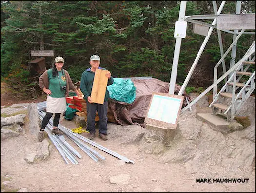

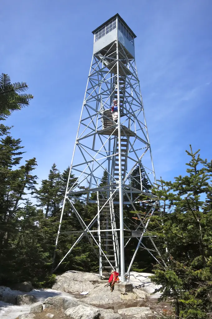

Photos keep their own rights and are shown with credit. Is one of these yours? You can ask for a different credit or for removal.
Where sources disagree
We show disagreements between sources instead of quietly picking one. If you know which is right, please tell us.
Sources disagree on the location by 550 m.
- NHLR: 43.08599, −72.92485
- FOREST LOOKOUTS -- eastern US (easternuslookouts.weebly.com): 43.09050, −72.92760
The map uses the position from NHLR.
Sources disagree on whether it still stands.
- FFLA: Standing
- NHLR: Standing
- FOREST LOOKOUTS -- eastern US (easternuslookouts.weebly.com): Gone
NHLR lists lookouts that were standing when registered.
Sources
- National Historic Lookout Register (NHLR) (opens another site) Gave us: name, location, county, elevation, what it is built of, register numbers, agency, ownership, dates, photos, links National Historic Lookout Register (nhlr.org) · All rights reserved (American Resources, Inc.); facts extracted only, no prose copied. · retrieved 4 Oct 2026
- Forest Fire Lookout Association (FFLA) - US lookout lists (opens another site) Gave us: type, status, register numbers, links Forest Fire Lookout Association (firelookout.org) · No licence stated; facts extracted only, no prose copied. · retrieved 8 Oct 2026
- FOREST LOOKOUTS -- eastern US (easternuslookouts.weebly.com) (opens another site) Gave us: height, photos, links easternuslookouts.weebly.com · No licence stated; facts only (county, coordinates where the page's own map widget gives them, status, height, design hints, register links). The site's own historical quotes, newspaper citations and narrative are not reproduced. · retrieved 8 Oct 2026
- Forest Fire Lookout Association chapter reports (opens another site) Gave us: dates, links Forest Fire Lookout Association, chapter and restoration-grant reports (firelookout.org) · No licence stated; facts only (dates, names, the kind of work done). Every note is our own wording and every event links to the FFLA report it comes from. Positions are copied from the NHLR, FFLOS and FFLA records. · retrieved 8 Oct 2026
- Wikidata -- US fire lookout towers (Q748998 and subclasses) (opens another site) Gave us: register numbers, dates, photos, links Wikidata · CC0 1.0 (Wikidata). Images keep their own Commons licence/credit. · retrieved 4 Oct 2026
- OpenStreetMap -- fire lookout structures (opens another site) Gave us: links © OpenStreetMap contributors · ODbL 1.0. (c) OpenStreetMap contributors. · retrieved 4 Oct 2026
- Firefinder research Gave us: summary, design, height, status, agency, access, visiting details, dates, links, fact-check Firefinder research (sources cited in the story footnotes) · Our own research notes; each fact cites its source in the lookout's story
More about this lookout elsewhere
- NHLR register entry US 48 (nhlr.org) (opens another site)
- NHLR register entry (nhlr.org) (opens another site)
- Stratton Mountain Lookout Tower, National Register of Historic Places nomination (National Park Service (NPGallery)) (opens another site)
- Stratton Mountain Trail (USDA Forest Service, Green Mountain and Finger Lakes National Forests) (opens another site)
- Stratton Mountain Fire Warden's Cabin (Green Mountain Club, Burlington Section) (opens another site)
- FFLA Vermont lookout list (firelookout.org) (opens another site)
- Forest Fire Lookout Association chapter reports: work on Stratton Mountain Lookout (opens another site)
- Stratton Mountain (easternuslookouts.weebly.com) (opens another site)
- Wikidata item Q86928607 (opens another site)
- OpenStreetMap node 356555377 (opens another site)
Firefinder takes facts (places, dates, numbers) from these sources and writes its own words. See all sources and licences.