Fire lookout · Douglas County, Washington
Badger Mountain Lookout Site
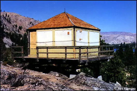
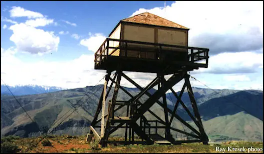
Douglas Co., WA tower built 1941 off national forest land near Wenatchee; cab moved in 1999 to the Columbia Breaks Fire Interpretive Center at Entiat, where it sits by a public trail.
- Moved
- Open to the public
- Verified
The lookout that stood here was moved. Now at CBFIC
Moved: The structure was moved. The map shows where it stands now; the timeline says where it came from. The cab moved in 1999 to the Columbia Breaks Fire Interpretive Center at Entiat. Sources do not say what became of the tower or whether anything remains on the mountain.
Visit & stay
Not rentable. As far as we know, this lookout cannot be booked for overnight stays.
Access
Open to the public. The cab is at the Columbia Breaks Fire Interpretive Center north of Entiat. A 2022 visit found the building closed but the parking area and interpretive trail open. The original mountain site was reached through private property, and no source describes access to it today.
- Can you climb it?
- Unknown
- Road to the top?
- Unknown
- Staffing
- Unknown
Facts
- Status
- Type
- Cab on a tower18-foot wooden tower with L-4 cabThe design: L-4
- Built of
- Not recorded
- Built
- 1941
- Height
- Unknown
- Elevation
- 3,498 ft (1,066 m)
- Agency
- U.S. Forest Service
- Land
- Federal land
- Location
- Douglas County, Washington
- Coordinates
- 47.51030, −120.24308
- Registers
- This entry
- VerifiedResearched, then checked independently. Updated 9 Oct 2026.
- Firefinder id
us-wa-badger-mountain
View from the cab
What you see from the cab: every ridge out to about 93 miles, the named peaks in sight, and other fire lookouts within view, worked out from terrain data in your browser.
The structure was moved. This view is from the position Firefinder shows for this record, at a typical height for a lookout like it.
Downloads about 3.5 MB of terrain data the first time.
Or see what it could see on the map: the ground in its line of sight.
History
Then and now
- 1930 StaffedMay 1930 item: Richard Basset employed to attend the lookout station on Badger Mountain that season.Source: washingtonlookouts.weebly.com
- 1941 BuiltTower built in 1941 per FFLOS and Firelookout. A 2022 visitor account says the cab was first built in the 1930s for Lion Rock (see resolved_conflicts).Sources: firetower.org, firelookout.com, theroamingcivic.com
- 1946 StaffedBarbara Calder named as lookout for 1946 to 1947.Source: firelookout.com
- 1948 StaffedGeorge Poling named as lookout for 1948 to 1950.Source: firelookout.com
- 1953 StaffedOscar Richardson named as lookout for 1953 to 1974. No later staffing is named in the sources.Source: firelookout.com
- 1961 EventMay 1961 newspaper item: Lowry Construction Co. was apparent low at $72,578 to build an unmanned gap filler facility, part of a radar installation near the Badger Mountain Lookout Station.Source: washingtonlookouts.weebly.com
- No record between 1961 and 1999
- 1999 MovedCab moved to the Columbia Breaks Fire Interpretive Center at Entiat.Source: firetower.org
- 2012 Added to the Former Fire Lookout Sites RegisterRegistered on the Former Fire Lookout Sites register as US 1383, WA 283 on August 20, 2012.Source: firetower.org
- Date unknown MovedThe lookout was moved to CBFIC.Source: FFLA
- TodayMovedThe structure was moved. The map shows where it stands now; the timeline says where it came from. When it came down is not recorded.
Old maps of this spot
USGS topographic maps from the years a lookout stood may show it, often as a small symbol labelled “Lookout”. See the old topo maps around it on the Firefinder map, or find every scanned sheet of this spot on USGS TopoView (opens another site) (click the spot there to list them, with dates and downloads).
Story
Researched 9 Oct 2026, fact-checked.
The Badger Mountain lookout was set a little below the crest of a high mesa in Douglas County, Washington.1,2 Sources place it seven or eight miles north-northeast of Wenatchee.3,2
According to the Register, an 18-foot wooden lookout with an L-4 cab went up in 1941. It served the Wenatchee National Forest from a spot on the other side of the Columbia River until the 1980s, even though the site was not on national forest land.1
A 2022 visitor's account says the cab was first built in the 1930s by the Civilian Conservation Corps for a lookout called Lion Rock, and was later moved to Badger Mountain.4 A 1930 newspaper item already describes a lookout station on Badger Mountain, so the sources do not agree on when a station first stood there.2
The 1930 item reports that Richard Basset was hired to staff the station that season.2 The Firelookout listing names Barbara Calder for 1946 to 1947, George Poling for 1948 to 1950, and Oscar Richardson for 1953 to 1974.3 In 1961 a newspaper item reported a low bid to build an unmanned radar gap-filler facility near the Badger Mountain Lookout Station.2
When the lookout stood, access ran through private property.1 The cab went to the Columbia Breaks Fire Interpretive Center at Entiat in 1999.1 The sources do not say what became of the tower itself, and we found no source that describes the mountain site today.
The center lies north of Entiat along Highway 97A today.5 Its history says the center grew out of a wish to rescue an old Forest Service lookout and move it down from the mountains to a highway with more traffic.5 On a 2022 visit the building was closed, but the parking area and the half-mile interpretive trail were open, and the trail features three relocated lookouts.4 Visit Wenatchee describes the center as built around two lookout towers, so the count differs by source.6,4 Check the center's hours before you visit.
- Badger Mountain Lookout Site, Former Fire Lookout Sites Register, http://firetower.org/lookouts/us/wa/badger-mountain-lookout-site/ (accessed 2026-10-09). ↩
- Badger Mountain, Forest Lookouts (Washington), https://washingtonlookouts.weebly.com/badger-mountain.html (accessed 2026-10-09). ↩
- Badger Mtn. Fire Lookout Tower, Firelookout.com, https://www.firelookout.com/wa/badgermtn.html (accessed 2026-10-09). ↩
- Columbia Breaks Fire Interpretive Center, The Roaming Civic, https://theroamingcivic.com/2022/03/25/columbia-breaks-fire-interpretive-center/ (accessed 2026-10-09). ↩
- Our History, Columbia Breaks Fire Interpretive Center, https://www.columbiabreakswildfire.com/index/our-history (accessed 2026-10-09). ↩
- Columbia Breaks Fire Interpretive Center, Visit Wenatchee, https://www.visitwenatchee.org/listing/columbia-breaks-fire-interpretive-center (accessed 2026-10-09). ↩
Photos
Photos keep their own rights and are shown with credit. Is one of these yours? You can ask for a different credit or for removal.
Sources
- Former Fire Lookout Sites Register (FFLOS) (opens another site) Gave us: name, location, county, elevation, register numbers, agency, ownership, dates, photos, links Former Fire Lookout Sites Register (firetower.org) · All rights reserved (American Resources, Inc.); facts extracted only, no prose copied. · retrieved 4 Oct 2026
- Forest Fire Lookout Association (FFLA) - US lookout lists (opens another site) Gave us: type, status, register numbers, links Forest Fire Lookout Association (firelookout.org) · No licence stated; facts extracted only, no prose copied. · retrieved 8 Oct 2026
- firelookout.com -- Rex Kamstra's Forest Fire Lookout Page (opens another site) Gave us: links firelookout.com · No licence stated on the site; facts only (coordinates, elevation, built/destroyed years, design, agency). Photos mirrored with the site's stated credit. · retrieved 4 Oct 2026
- FOREST LOOKOUTS -- western US (Ron Kemnow's weebly sites) (opens another site) Gave us: links Ron Kemnow's Forest Lookouts sites (westlookouts, californialookouts, idaholookouts, montanalookouts, oregonlookouts and washingtonlookouts .weebly.com) · No licence stated; facts only (county, land manager, status word, coordinates where the page's own map widget gives them, township-range-section, height and design hints, links). The site's own newspaper quotes, citations and narrative are not reproduced. · retrieved 8 Oct 2026
- Firefinder research Gave us: summary, design, status, agency, access, dates, links, fact-check Firefinder research (sources cited in the story footnotes) · Our own research notes; each fact cites its source in the lookout's story
More about this lookout elsewhere
- FFLOS register entry US 1383 (firetower.org) (opens another site)
- Columbia Breaks Fire Interpretive Center (The Roaming Civic (theroamingcivic.com)) (opens another site)
- Our History (Columbia Breaks Fire Interpretive Center) (opens another site)
- Columbia Breaks Fire Interpretive Center (Visit Wenatchee (visitwenatchee.org)) (opens another site)
- FFLA Washington lookout list (firelookout.org) (opens another site)
- Badger Mtn. on firelookout.com (Rex Kamstra) (opens another site)
- Badger Mountain on Forest Lookouts, western US (Ron Kemnow) (opens another site)
Firefinder takes facts (places, dates, numbers) from these sources and writes its own words. See all sources and licences.