Fire lookout · Chelan County, Washington
Big Hill Lookout Site
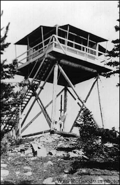
Chelan County, WA 24-ft pole L-4 lookout built 1933 and removed in the 1950s; its converted garage still stands on the summit, now a drive-up campground per WillhiteWeb.
- Gone
- Open to the public
- Verified
Gone: The lookout no longer stands. Only the site is left.
Visit & stay
Gone: site only. The lookout no longer stands, so there is nothing to climb or rent. You may still be able to visit the site.
Access
Open to the public. Drive-up summit campground per WillhiteWeb; road over Shady Pass from Entiat, conditions change; no closure described
- Road to the top?
- Yes, you can drive up
Facts
- Status
- Type
- Cab on a tower24-foot pole L-4 tower with an accompanying garageThe design: L-4
- Built of
- Wood
- Also served as
- Aircraft Warning Service postDuring the Second World War it was staffed to spot and report aircraft.
- Built
- 1933
- Height
- 24 ft (7.3 m)
- Elevation
- 6,827 ft (2,081 m)
- Agency
- U.S. Forest Service
- Land
- Federal land
- Location
- Chelan County, Washington
- Coordinates
- 48.01562, −120.49243
- Registers
- This entry
- VerifiedResearched, then checked independently. Updated 9 Oct 2026.
- Firefinder id
us-wa-big-hill
View from the cab
What the lookout saw from its cab: every ridge out to about 93 miles, the named peaks in sight, and other fire lookouts within view, worked out from terrain data in your browser.
This lookout is gone. The view is reconstructed from its recorded site and its recorded height.
Downloads about 4.2 MB of terrain data the first time.
Or see what it could see on the map: the ground in its line of sight.
History
Then and now
- 1933 Built24-foot pole L-4 tower and an accompanying garage; WillhiteWeb says likely built by the CCCSources: firetower.org, firelookout.com, willhiteweb.com
- 1942 AlteredGarage converted into Aircraft Warning Service living quartersSources: firetower.org, willhiteweb.com
- 1942 EventAircraft Warning Service post activated March 20, 1942; deactivated July 1, 1943 (Seattle Filter Center)Source: washingtonlookouts.weebly.com
- 1950 RemovedTower removed sometime in the 1950s; the register gives no exact yearSources: firetower.org, firelookout.com, willhiteweb.com
- No record between 1950 and 1968
- 1968 EventSummit shown as a campground on the 1968 topo map; maps today show the sameSource: willhiteweb.com
- 1970 FireEntiat Burn lightning fires in the Wenatchee National Forest; a note in the cabin dated 9/2/70 refers to the Shady Pass Fire and to charred landSource: willhiteweb.com
- No record between 1970 and 2012
- 2012 Added to the Former Fire Lookout Sites RegisterRegistered August 20, 2012 as US 1387, WA 287; nominated by Ray KresekSource: firetower.org
- TodayGoneThe lookout no longer stands. Only the site is left.
Old maps of this spot
USGS topographic maps from the years a lookout stood may show it, often as a small symbol labelled “Lookout”. See the old topo maps around it on the Firefinder map, or find every scanned sheet of this spot on USGS TopoView (opens another site) (click the spot there to list them, with dates and downloads).
Story
Researched 9 Oct 2026, fact-checked.
Big Hill is a summit in Chelan County, Washington, in the Wenatchee National Forest, at 6,827 feet.1,2
The register says the lookout was constructed in 1933 as a 24-foot pole L-4 tower, with an accompanying garage.1,2 WillhiteWeb says the Civilian Conservation Corps likely built it.3
The garage was used alongside the tower until 1942, when it was turned into living quarters for the Aircraft Warning Service.3,1 Rex's Fire Lookout Page gives that post's activation date as March 20, 1942, and its deactivation as July 1, 1943, under the Seattle Filter Center.4
The register says the tower was removed in the 1950s.1 WillhiteWeb says it stood until some point in that decade.3
In August 1970, lightning started fires across the Wenatchee National Forest. WillhiteWeb calls them the Entiat Burn, says they burned 122,000 acres, and says five merged fires included the Shady Pass Fire.3 A note on a cardboard sign inside the cabin, dated 9/2/70, refers to the Shady Pass Fire and says the ground was burned black, yet the house was still there.3
Today WillhiteWeb says the converted garage still stands on the summit, with bunks, a wood stove and some interpretive signs.3 Once the lookout period ended, the summit was regarded as a campground, and the 1968 topo map and current maps both show that.3
Access is by road. The route leaves Entiat along the Entiat River Road, passes Box Canyon, and crosses Shady Pass.3 Conditions shift, but WillhiteWeb says passenger cars have managed the road before.3
- Big Hill Lookout Site, Former Fire Lookout Sites register, Forest Fire Lookout Association, http://firetower.org/lookouts/us/wa/big-hill-lookout-site/ (accessed 2026-10-09). ↩
- Big Hill Fire Lookout Tower, firelookout.com, https://www.firelookout.com/wa/bighill.html (accessed 2026-10-09). ↩
- Big Hill - Shady Pass - Lake Chelan - Entiat, WillhiteWeb, https://willhiteweb.com/washington_fire_lookouts/big_hill/entiat_chelan_383.htm (accessed 2026-10-09). ↩
- Big Hill - Forest Lookouts, Rex's Fire Lookout Page, https://washingtonlookouts.weebly.com/big-hill1.html (accessed 2026-10-09). ↩
Photos
Photos keep their own rights and are shown with credit. Is one of these yours? You can ask for a different credit or for removal.
Sources
- Former Fire Lookout Sites Register (FFLOS) (opens another site) Gave us: name, location, county, elevation, what it is built of, wartime use, register numbers, agency, ownership, dates, photos, links Former Fire Lookout Sites Register (firetower.org) · All rights reserved (American Resources, Inc.); facts extracted only, no prose copied. · retrieved 4 Oct 2026
- Forest Fire Lookout Association (FFLA) - US lookout lists (opens another site) Gave us: type, status, register numbers, links Forest Fire Lookout Association (firelookout.org) · No licence stated; facts extracted only, no prose copied. · retrieved 8 Oct 2026
- firelookout.com -- Rex Kamstra's Forest Fire Lookout Page (opens another site) Gave us: links firelookout.com · No licence stated on the site; facts only (coordinates, elevation, built/destroyed years, design, agency). Photos mirrored with the site's stated credit. · retrieved 4 Oct 2026
- FOREST LOOKOUTS -- western US (Ron Kemnow's weebly sites) (opens another site) Gave us: links Ron Kemnow's Forest Lookouts sites (westlookouts, californialookouts, idaholookouts, montanalookouts, oregonlookouts and washingtonlookouts .weebly.com) · No licence stated; facts only (county, land manager, status word, coordinates where the page's own map widget gives them, township-range-section, height and design hints, links). The site's own newspaper quotes, citations and narrative are not reproduced. · retrieved 8 Oct 2026
- Firefinder research Gave us: summary, design, height, agency, access, visiting details, dates, links, fact-check Firefinder research (sources cited in the story footnotes) · Our own research notes; each fact cites its source in the lookout's story
More about this lookout elsewhere
- FFLOS register entry US 1387 (firetower.org) (opens another site)
- Big Hill - Shady Pass - Lake Chelan - Entiat (WillhiteWeb) (opens another site)
- FFLA Washington lookout list (firelookout.org) (opens another site)
- Big Hill on firelookout.com (Rex Kamstra) (opens another site)
- Big Hill on Forest Lookouts, western US (Ron Kemnow) (opens another site)
Firefinder takes facts (places, dates, numbers) from these sources and writes its own words. See all sources and licences.