Fire lookout · Pend Oreille County, Washington
Boyer Mountain Lookout Site
Pend Oreille County summit with a 1925 platform tower and a 72-foot L-6 tower built 1937; toppled by vandals in 1975. WillhiteWeb photo captions show footings marked 2026 and cab remnants nearby.
- Gone
- Restricted access
- Verified
Gone: The lookout no longer stands. Only the site is left. Tower toppled by vandals in 1975 and never replaced; WillhiteWeb photo captions show footings marked 2026 at the south summit and cab remnants about 80 feet from them
Visit & stay
Gone: site only. The lookout no longer stands, so there is nothing to climb or rent.
Access
Restricted access
Access is seasonal, gated or needs a permit. Check before you go. Most roads nearby are gated; the route ends at an old gate with a tank trap, and a wildlife closure area permanently ended the road. No current permit or closure notice found in the sources read.
- Road to the top?
- No, you have to hike
- Trail
- No tower stands. WillhiteWeb's route: about 1 mile up Middle Fork Road, roughly 8 miles on Power Lake Road, then a trail for the last part. WillhiteWeb lists the hike at 2.2 miles one-way.
Facts
- Status
- Type
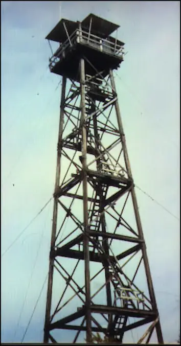
- Cab on a tower72' treated timber L-6 tower with frame cabin (1937), after a 1925 log cabin and platform tower and a 1929 cupola cabinThe design: L-6
- Built of
- Not recorded
- Built
- 1925
- Height
- 72 ft (21.9 m)
- Elevation
- 5,252 ft (1,601 m)
- Agency
- U.S. Forest Service/Washington DNR
- Land
- State land
- Location
- Pend Oreille County, Washington
- Coordinates
- 48.19458, −117.43587
- Registers
- This entry
- VerifiedResearched, then checked independently. Updated 9 Oct 2026.
- Firefinder id
us-wa-boyer-mountain
View from the cab
What the lookout saw from its cab: every ridge out to about 93 miles, the named peaks in sight, and other fire lookouts within view, worked out from terrain data in your browser.
This lookout is gone. The view is reconstructed from its recorded site and its recorded height.
Downloads about 4.3 MB of terrain data the first time.
Or see what it could see on the map: the ground in its line of sight.
History
Then and now
- 1925 BuiltLog cabin and platform observation tower developed on the south end of the summit (register)Sources: firetower.org, willhiteweb.com
- 1929 BuiltCupola cabin built on the north end (register); Division of Forestry report says Boyer Mountain went into operation in 1929Sources: firetower.org, willhiteweb.com, washingtonlookouts.weebly.com
- 1930 First staffedJune 19, 1930 Newport Miner item: Ernest Hart to be stationed at Boyer; WillhiteWeb names him as the 1930 lookoutSources: washingtonlookouts.weebly.com, willhiteweb.com
- 1937 Built72-foot treated timber L-6 tower with frame cabin living quarters built on the south summitSources: firetower.org, firelookout.com, washingtonlookouts.weebly.com
- 1938 AlteredTower received two-way radio equipmentSources: washingtonlookouts.weebly.com, willhiteweb.com
- 1942 StaffedNewport Miner, July 2, 1942: eight Newport district lookouts being manned that week, the first being Boyer MountainSource: washingtonlookouts.weebly.com
- 1951 EventState officials called in one Boyer lookout while continuing five others (Statesman Examiner item, September 14, 1951, quoted by Forest Lookouts)Source: washingtonlookouts.weebly.com
- 1957 StaffedEarle Gray was the lookout in 1957 and 1958Sources: firelookout.com, willhiteweb.com
- 1960 EventWould not be manned that year; money redirected to plane patrol after lightning storms (Spokane Daily Chronicle)Sources: washingtonlookouts.weebly.com, willhiteweb.com
- No record between 1960 and 1975
- 1975 DestroyedToppled by vandals in 1975 and never replacedSources: firetower.org, firelookout.com, washingtonlookouts.weebly.com
- No record between 1975 and 2012
- 2012 Added to the Former Fire Lookout Sites RegisterRegistered November 23, 2012; nominated by Ray KresekSource: firetower.org
- TodayGoneThe lookout no longer stands. Only the site is left.
Old maps of this spot
USGS topographic maps from the years a lookout stood may show it, often as a small symbol labelled “Lookout”. See the old topo maps around it on the Firefinder map, or find every scanned sheet of this spot on USGS TopoView (opens another site) (click the spot there to list them, with dates and downloads).
Story
Researched 9 Oct 2026, fact-checked.
Boyer Mountain is a summit in Pend Oreille County, about 18 miles west of Newport, on the Kaniksu and Colville national forests.1,2 The register gives its elevation as 5,252 feet, while WillhiteWeb gives 5,280.1,3
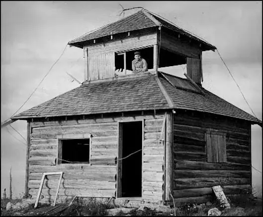
The register says the summit was developed in 1925 with a log cabin and a platform observation tower on the south end.1 A cupola cabin went up on the north end in 1929.1,3 A Division of Forestry report quoted by the Forest Lookouts page says Boyer Mountain was one of three new lookouts put into operation in 1929.4 The sources disagree on when the lookout began, so we give both dates.
In 1937 a 72-foot treated timber tower with an L-6 cab and frame living quarters went up on the south summit.1,3,4
A June 1930 Newport Miner item said Ernest Hart was to be stationed at Boyer.4 WillhiteWeb also names him as the lookout in 1930.3 Earle Gray was the lookout in 1957 and 1958.2,3 In July 1942 the Newport Miner reported that the eight lookout stations in the Newport district were being manned that week, with Boyer Mountain first.4 The tower received two-way radio equipment in 1938.4,3
In September 1951 a Statesman Examiner item said state officials called in one lookout on Boyer Mountain while keeping five others running.4 In 1960 the Spokane Daily Chronicle reported that Boyer would not be manned that year, and its money would go to plane patrols after lightning storms.4,3 We found no fire reports from the lookout in the sources we read.
Vandals toppled the tower in 1975, and it was never replaced.1,2,4,3 The Forest Fire Lookout Association's Washington list shows the site as a tower that is gone.5
WillhiteWeb's photo captions show footings marked 2026 at the south summit, and cab remnants about 80 feet from those footings.3 The sources do not say whether anything else remains.
Access is restricted. Most roads in the area are gated, and the route WillhiteWeb describes ends at an old gate with a large tank trap just beyond.3 A wildlife closure area permanently ended the road.3 The route runs up Middle Fork Road for about a mile and then Power Lake Road for roughly eight miles, and a trail covers the last part.3 The page says the route was still usable as of 2026, though the final quarter mile of trail is overgrowing quickly.3 We found no current closure notice or permit rule in the sources, so check with the land managers before going.
- Boyer Mountain Lookout Site, Former Fire Lookout Sites register, http://firetower.org/lookouts/us/wa/boyer-mountain-lookout-site/ (accessed 2026-10-09). ↩
- Boyer Mtn. Fire Lookout Tower, Firelookout.com, https://www.firelookout.com/wa/boyermtn.html (accessed 2026-10-09). ↩
- Boyer Mountain on Blue Grouse Mountain, WillhiteWeb.com, http://willhiteweb.com/fire_lookouts/boyer_mountain/lookout_371.htm (accessed 2026-10-09). ↩
- Boyer Mountain, Forest Lookouts, https://washingtonlookouts.weebly.com/boyer-mountain.html (accessed 2026-10-09). ↩
- Washington Lookouts, Forest Fire Lookout Association, https://firelookout.org/lookouts/us/wa/ (accessed 2026-10-09). ↩
Photos
Photos keep their own rights and are shown with credit. Is one of these yours? You can ask for a different credit or for removal.
Sources
- Former Fire Lookout Sites Register (FFLOS) (opens another site) Gave us: name, location, county, elevation, register numbers, agency, dates, photos, links Former Fire Lookout Sites Register (firetower.org) · All rights reserved (American Resources, Inc.); facts extracted only, no prose copied. · retrieved 4 Oct 2026
- Forest Fire Lookout Association (FFLA) - US lookout lists (opens another site) Gave us: type, status, register numbers, links Forest Fire Lookout Association (firelookout.org) · No licence stated; facts extracted only, no prose copied. · retrieved 8 Oct 2026
- firelookout.com -- Rex Kamstra's Forest Fire Lookout Page (opens another site) Gave us: links firelookout.com · No licence stated on the site; facts only (coordinates, elevation, built/destroyed years, design, agency). Photos mirrored with the site's stated credit. · retrieved 4 Oct 2026
- FOREST LOOKOUTS -- western US (Ron Kemnow's weebly sites) (opens another site) Gave us: ownership, links Ron Kemnow's Forest Lookouts sites (westlookouts, californialookouts, idaholookouts, montanalookouts, oregonlookouts and washingtonlookouts .weebly.com) · No licence stated; facts only (county, land manager, status word, coordinates where the page's own map widget gives them, township-range-section, height and design hints, links). The site's own newspaper quotes, citations and narrative are not reproduced. · retrieved 8 Oct 2026
- WillhiteWeb.com: Washington Fire Lookouts (opens another site) Gave us: links WillhiteWeb.com · No licence stated; names and page links only (the site's photos and text are not reproduced). · retrieved 8 Oct 2026
- Firefinder research Gave us: summary, design, height, status, agency, access, visiting details, dates, links, fact-check Firefinder research (sources cited in the story footnotes) · Our own research notes; each fact cites its source in the lookout's story
More about this lookout elsewhere
- FFLOS register entry US 1485 (firetower.org) (opens another site)
- FFLA Washington lookout list (firelookout.org) (opens another site)
- Boyer Mtn. on firelookout.com (Rex Kamstra) (opens another site)
- Boyer Mountain on Forest Lookouts, western US (Ron Kemnow) (opens another site)
- Boyer Mountain on WillhiteWeb.com Washington Fire Lookouts (opens another site)
Firefinder takes facts (places, dates, numbers) from these sources and writes its own words. See all sources and licences.