Fire lookout · Okanogan County, Washington
Bunker Hill Lookout Site (Okanogan County)
Also known as Bunker Hill
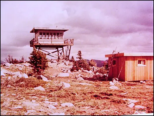
1930 L-4 cab lookout on Bunker Hill in the Okanogan NF; 1960 R-6 tower burned in 1973. WillhiteWeb photo captions note footings; site lies in Pasayten Wilderness.
- Gone
- Open to the public
- Verified
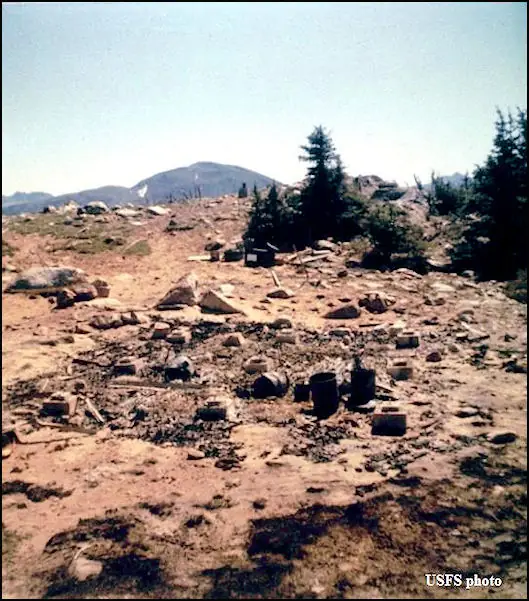
Gone: The lookout no longer stands. Only the site is left. Tower burned in 1973 and structures removed by burning. WillhiteWeb photo captions note footings at the site. No source describes other remains.
Visit & stay
Gone: site only. The lookout no longer stands, so there is nothing to climb or rent. You may still be able to visit the site.
Access
Open to the public. In the Pasayten Wilderness. Listed routes are 26 miles from Billy Goat trailhead via Sand Ridge, or 22 miles via Dean Creek, which is marked closed. Recent fires have made access harder.
- Road to the top?
- No, you have to hike
- Trail
- No tower stands. The Boundary Trail crosses the summit, per WillhiteWeb.
Facts
- Status
- Type
- Cab on a tower1930 L-4 cab lookout house (gable roof, per WillhiteWeb); 1960 10-foot treated timber R-6 flat towerThe designs: L-4, R-6
- Built of
- Not recorded
- Built
- 1930
- Height
- Unknown
- Elevation
- 7,239 ft (2,206 m)
- Agency
- U.S. Forest Service, Okanogan National Forest
- Land
- Federal land
- Location
- Okanogan County, Washington
- Coordinates
- 48.97396, −120.48399
- Registers
- This entry
- VerifiedResearched, then checked independently. Updated 9 Oct 2026.
- Firefinder id
us-wa-bunker-hill-okanogan-county
View from the cab
What the lookout saw from its cab: every ridge out to about 93 miles, the named peaks in sight, and other fire lookouts within view, worked out from terrain data in your browser.
This lookout is gone. The view is reconstructed from its recorded site and a typical height for a lookout like it.
Downloads about 4.2 MB of terrain data the first time.
Or see what it could see on the map: the ground in its line of sight.
History
Then and now
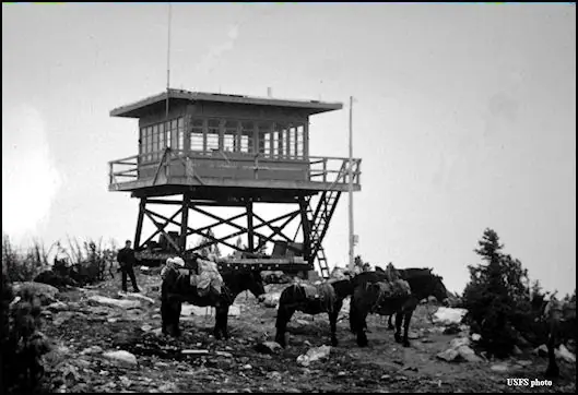
- 1930 BuiltL-4 cab lookout house built per the register, firelookout.com and WillhiteWeb; the Washington lookout list quotes an Aladdin lookout house instead. Materials packed in 25 miles from Billy Goat Corral.Sources: firetower.org, firelookout.com, willhiteweb.com
- 1932 StaffedAl Anderson named as lookout (WillhiteWeb)Source: willhiteweb.com
- 1942 EventSummer AWS station at the site, activated July 12 and deactivated September 18 (WillhiteWeb); Washington lookout list lists the same dates with Seattle Filter CenterSources: willhiteweb.com, washingtonlookouts.weebly.com
- 1955 BurnedCabin destroyed by fire in July 1955 while the lookout, Mickey Nickell, was away getting water (Methow Valley News, quoted by the lookout list). Firelookout.com says it accidentally burned in 1955.Sources: firelookout.com, washingtonlookouts.weebly.com
- 1955 StaffedMickey Nickell of Twisp, lookout in 1955Sources: firelookout.com, washingtonlookouts.weebly.com
- 1958 BurnedWillhiteWeb: cab accidentally burned, likely in 1958 but no date known. Conflicts with the 1955 date in the other sources.Source: willhiteweb.com
- 1959 StaffedChuck Casey named as lookout; WillhiteWeb says lookouts used a wall tent after the cab burnedSources: firelookout.com, willhiteweb.com
- 1960 Replaced by a new structureLookout replaced with a 10-foot treated timber R-6 flat towerSources: firetower.org, firelookout.com, willhiteweb.com
- 1962 StaffedGazette-Tribune item: men stationed at Bunker Hill and Monument 83 lookouts that JulySource: washingtonlookouts.weebly.com
- 1966 Last staffedWillhiteWeb: the tower was last used in 1966Source: willhiteweb.com
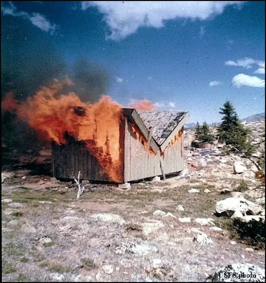
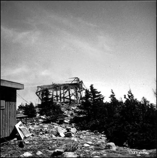
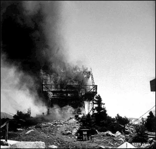
- 1973 BurnedTower deliberately burned (firelookout.com); register says burned in 1973Sources: firetower.org, firelookout.com
- 1973 RemovedForest Service removed the structures by burningSource: washingtonlookouts.weebly.com
- No record between 1973 and 2012
- 2012 Added to the Former Fire Lookout Sites RegisterFormer Fire Lookout Sites registration dated November 10, 2012Source: firetower.org
- TodayGoneThe lookout no longer stands. Only the site is left.
Old maps of this spot
USGS topographic maps from the years a lookout stood may show it, often as a small symbol labelled “Lookout”. See the old topo maps around it on the Firefinder map, or find every scanned sheet of this spot on USGS TopoView (opens another site) (click the spot there to list them, with dates and downloads).
Story
Researched 9 Oct 2026, fact-checked.
A lookout went up on Bunker Hill in 1930, in the Okanogan National Forest about 37 miles north-northwest of Winthrop.1,2 WillhiteWeb describes an L-4 cab with a gable roof, and adds that the materials came in from Billy Goat Corral, 25 miles away.3 A Washington lookout list quotes another account, which calls the first building an Aladdin lookout house, so the sources do not agree on the design.4
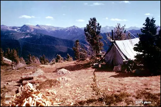
Named lookouts include Al Anderson in 1932, Mickey Nickell in 1955 and Chuck Casey in 1959.3,2 In July 1955 fire destroyed the cabin while Nickell was at a spring getting water. The newspaper said the origin of the fire was not definitely known.4 Firelookout.com says it burned accidentally that year.2 WillhiteWeb says the cab was accidentally burned, likely in 1958 but with no known date, and that lookouts were using a wall tent in 1959.3
A 10-foot treated timber R-6 flat tower took the place of the lookout in 1960.1,2,3 WillhiteWeb says that tower was last used in 1966.3 In July 1962 a Gazette-Tribune item reported men packing in to stations at Bunker Hill and Monument 83.4
The tower burned in 1973. The register says it was burned that year, and firelookout.com calls the burn deliberate.1,2 That year the Forest Service burned away the structures.4 WillhiteWeb has a photo captioned "Shed burning in 1973."3
WillhiteWeb's photo captions note footings at the site, including one reading "Three footings showing a wide base."3 None of the sources cited here describes anything else left there today.
WillhiteWeb places the site in the Pasayten Wilderness, and says the open slopes and meadows around the hill see few visitors now.3 Its listed routes start 26 miles from Billy Goat trailhead via Sand Ridge, or 22 miles via Dean Creek, which the page marks closed.3 Recent fires have made access harder.3
- Bunker Hill Lookout Site (Okanogan County), Former Fire Lookout Sites register, http://firetower.org/lookouts/us/wa/bunker-hill-lookout-site-okanogan-county/ (accessed 2026-10-09). ↩
- Bunker Hill Fire Lookout Tower, firelookout.com, https://www.firelookout.com/wa/bunkerhill.html (accessed 2026-10-09). ↩
- Bunker Hill Lookout Site - Pasayten Wilderness, WillhiteWeb.com, https://www.willhiteweb.com/pasayten_wilderness/bunker_hill_lookout/tower_067.htm (accessed 2026-10-09). ↩
- Bunker Hill - FOREST LOOKOUTS, Washington forest lookout list, https://washingtonlookouts.weebly.com/bunker-hill1.html (accessed 2026-10-09). ↩
Photos
Photos keep their own rights and are shown with credit. Is one of these yours? You can ask for a different credit or for removal.
Sources
- Former Fire Lookout Sites Register (FFLOS) (opens another site) Gave us: name, location, county, elevation, register numbers, agency, ownership, dates, photos, links Former Fire Lookout Sites Register (firetower.org) · All rights reserved (American Resources, Inc.); facts extracted only, no prose copied. · retrieved 4 Oct 2026
- Forest Fire Lookout Association (FFLA) - US lookout lists (opens another site) Gave us: type, status, register numbers, links Forest Fire Lookout Association (firelookout.org) · No licence stated; facts extracted only, no prose copied. · retrieved 8 Oct 2026
- firelookout.com -- Rex Kamstra's Forest Fire Lookout Page (opens another site) Gave us: links firelookout.com · No licence stated on the site; facts only (coordinates, elevation, built/destroyed years, design, agency). Photos mirrored with the site's stated credit. · retrieved 4 Oct 2026
- FOREST LOOKOUTS -- western US (Ron Kemnow's weebly sites) (opens another site) Gave us: links Ron Kemnow's Forest Lookouts sites (westlookouts, californialookouts, idaholookouts, montanalookouts, oregonlookouts and washingtonlookouts .weebly.com) · No licence stated; facts only (county, land manager, status word, coordinates where the page's own map widget gives them, township-range-section, height and design hints, links). The site's own newspaper quotes, citations and narrative are not reproduced. · retrieved 8 Oct 2026
- Firefinder research Gave us: summary, design, status, agency, access, visiting details, dates, links, fact-check Firefinder research (sources cited in the story footnotes) · Our own research notes; each fact cites its source in the lookout's story
More about this lookout elsewhere
- FFLOS register entry US 1434 (firetower.org) (opens another site)
- Bunker Hill Lookout Site - Pasayten Wilderness (WillhiteWeb.com) (opens another site)
- FFLA Washington lookout list (firelookout.org) (opens another site)
- Bunker Hill on firelookout.com (Rex Kamstra) (opens another site)
- Bunker Hill on Forest Lookouts, western US (Ron Kemnow) (opens another site)
Firefinder takes facts (places, dates, numbers) from these sources and writes its own words. See all sources and licences.