Fire lookout · Grays Harbor County, Washington
Burnt Hill Lookout Site
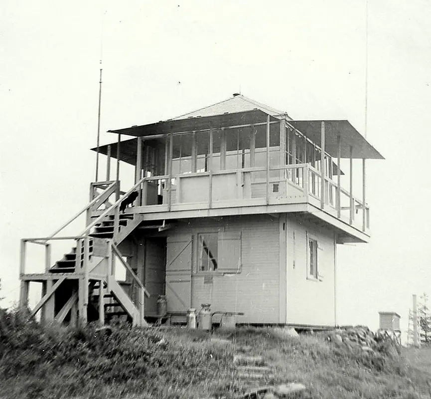
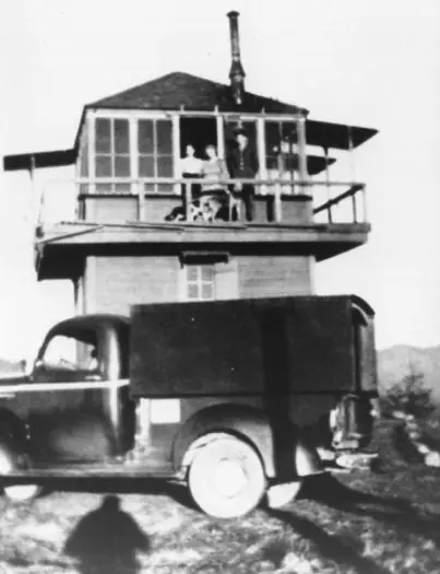
Grays Harbor County, WA lookout site: a two-story lookout from 1942, an Aircraft Warning Service post, a state tower in 1959; gone by 1967 or 1969 (sources differ). Private timber land.
- Gone
- Permission required
- Verified
Permission required
You need permission from the tribe or landowner before visiting. WillhiteWeb lists the landowner as a private timber company; no public access rights are described
Gone: The lookout no longer stands. Only the site is left. Lookout house and 1959 tower both gone; the register and Firelookout.com say gone by 1967, Forest Lookouts and WillhiteWeb say 1969; foundation block recorded in 1974
Visit & stay
Gone: site only. The lookout no longer stands, so there is nothing to climb or rent.
Access
Permission required. See the warning at the top of this page.
- Road to the top?
- Unknown
- Trail
- No tower remains to climb. WillhiteWeb describes a short dead-end Forest Service spur near the site.
Facts
- Status
- Type
- Cab on a towerR-6 14x14 foot cab on a two-story house; 1959 replacement was a 40-foot timber tower with live-in cabThe design: R-6
- Built of
- Not recorded
- Built
- 1942
- Height
- 10 ft (3.0 m)
- Elevation
- 1,258 ft (383 m)
- Agency
- Washington State Division of Forestry/DNR (Olympic National Forest ran the lookout before 1958)
- Land
- Federal land
- Location
- Grays Harbor County, Washington
- Coordinates
- 47.35465, −123.77034 sources disagree
- Registers
- This entry
- VerifiedResearched, then checked independently. Updated 9 Oct 2026.
- Firefinder id
us-wa-burnt-hill
View from the cab
What the lookout saw from its cab: every ridge out to about 93 miles, the named peaks in sight, and other fire lookouts within view, worked out from terrain data in your browser.
This lookout is gone. The view is reconstructed from its recorded site and its recorded height.
Downloads about 3.9 MB of terrain data the first time.
Or see what it could see on the map: the ground in its line of sight.
History
Then and now
- 1930 EventLookout first appears on 1930 and 1932 maps, per WillhiteWeb; builder not namedSource: willhiteweb.com
- 1942 BuiltTwo-story lookout with 14x14 cab, per a structural inventory quoted by Forest Lookouts and by WillhiteWeb; the register dates the first two-story house to 1943Sources: washingtonlookouts.weebly.com, willhiteweb.com
- 1942 StaffedAircraft Warning Service station Baker 7-1 activated March 10, 1942; WillhiteWeb names observers Clarence and Marie Locke without datesSources: washingtonlookouts.weebly.com, willhiteweb.com
- 1956 StaffedQuinault District manning the lookout during a dry period, per a May 18, 1956 Port Angeles Evening News item quoted by Forest LookoutsSource: washingtonlookouts.weebly.com
- 1958 EventLookout turned over to the StateSources: washingtonlookouts.weebly.com, willhiteweb.com
- 1959 Replaced by a new structureState (DNR) erected a 40-foot timber tower with live-in cabSources: firetower.org, washingtonlookouts.weebly.com, willhiteweb.com
- 1967 RemovedRegister and Firelookout.com say the 40-foot tower was gone by 1967Sources: firetower.org, firelookout.com
- 1969 RemovedForest Lookouts and WillhiteWeb say the tower was removed and the lookout house torn down in 1969Sources: washingtonlookouts.weebly.com, willhiteweb.com
- 1974 EventFoundation block of the lookout still there, per WillhiteWebSource: willhiteweb.com
- No record between 1974 and 2011
- 2011 Added to the Former Fire Lookout Sites RegisterRegistered November 26, 2011 as US 1158, WA 66Source: firetower.org
- TodayGoneThe lookout no longer stands. Only the site is left.
Old maps of this spot
USGS topographic maps from the years a lookout stood may show it, often as a small symbol labelled “Lookout”. See the old topo maps around it on the Firefinder map, or find every scanned sheet of this spot on USGS TopoView (opens another site) (click the spot there to list them, with dates and downloads).
Story
Researched 9 Oct 2026, fact-checked.
Burnt Hill is a summit of about 1,258 feet in Grays Harbor County, Washington.1,2 WillhiteWeb suggests the name may come from the harvested, burned-off summit seen in photographs taken in 1935.2
A lookout appears on maps from 1930 and 1932.2 Sources differ on when the first two-story house went up. Forest Lookouts quotes a structural inventory that dates it to 1942, while the register gives 1943.3,1
In March 1942 the summit became an Aircraft Warning Service post, Baker 7-1, tied to the Olympia Filter Center.3 It used existing structures that belonged to the Olympic National Forest.3 WillhiteWeb names Clarence and Marie Locke as the observers, but gives no dates for them.2 A May 1956 newspaper item said the Quinault District was manning the lookout during a dry spell.3 When the Aircraft Warning Service ended, the Forest Service kept the site for fire detection.3 The sources we read describe no particular fire the lookout spotted.
The site was on private land held by the Polsen Lumber Company, which the sources spell as both Polsen and Polson.3,2 In 1958 the state took over the lookout.3,2 In 1959 the state built a timber tower, 40 feet tall with a live-in cab, on the site.1,3
Sources disagree on when that tower came down. The register and Firelookout.com put its removal before 1967.1,4 The Forest Lookouts page and WillhiteWeb date its removal to 1969.3,2 A 1970 benchmark note recorded the lookout house as demolished in 1969 and said it would not be rebuilt.2 WillhiteWeb adds that its foundation block was still there in 1974.2
We found no source that describes the summit in detail after 1974. WillhiteWeb has 2017 photos, one captioned "Big clearing at the top," but its text does not say what remains.2
WillhiteWeb lists the landowner as a private timber company and describes a Forest Service spur road that dead-ends near the site.2 Because the land is private, ask the owner before going there.
- Burnt Hill Lookout Site, Former Fire Lookout Sites Register, http://firetower.org/lookouts/us/wa/burnt-hill-lookout-site/ (accessed 2026-10-09). ↩
- Burnt Hill Lookout Site, WillhiteWeb.com, http://www.willhiteweb.com/washington_fire_lookouts/burnt_hill/lookout_site_200.htm (accessed 2026-10-09). ↩
- Burnt Hill, Forest Lookouts, https://washingtonlookouts.weebly.com/burnt-hill.html (accessed 2026-10-09). ↩
- Burnt Hill Fire Lookout Tower, Firelookout.com, https://www.firelookout.com/wa/burnthill.html (accessed 2026-10-09). ↩
Photos
Photos keep their own rights and are shown with credit. Is one of these yours? You can ask for a different credit or for removal.
Where sources disagree
We show disagreements between sources instead of quietly picking one. If you know which is right, please tell us.
Sources disagree on the location by 7.8 km (4.9 mi).
- FFLOS: 47.35465, −123.77034
- FFLA: 47.35677, −123.86331
- firelookout.com -- Rex Kamstra's Forest Fire Lookout Page: 47.35677, −123.86331
- FOREST LOOKOUTS -- western US (Ron Kemnow's weebly sites): 47.32580, −123.86500
They share a register number.
The map uses the position from FFLOS.
Sources
- Former Fire Lookout Sites Register (FFLOS) (opens another site) Gave us: name, location, county, elevation, register numbers, agency, dates, photos, links Former Fire Lookout Sites Register (firetower.org) · All rights reserved (American Resources, Inc.); facts extracted only, no prose copied. · retrieved 4 Oct 2026
- Forest Fire Lookout Association (FFLA) - US lookout lists (opens another site) Gave us: type, status, register numbers, links Forest Fire Lookout Association (firelookout.org) · No licence stated; facts extracted only, no prose copied. · retrieved 8 Oct 2026
- firelookout.com -- Rex Kamstra's Forest Fire Lookout Page (opens another site) Gave us: links firelookout.com · No licence stated on the site; facts only (coordinates, elevation, built/destroyed years, design, agency). Photos mirrored with the site's stated credit. · retrieved 4 Oct 2026
- FOREST LOOKOUTS -- western US (Ron Kemnow's weebly sites) (opens another site) Gave us: design, height, ownership, links Ron Kemnow's Forest Lookouts sites (westlookouts, californialookouts, idaholookouts, montanalookouts, oregonlookouts and washingtonlookouts .weebly.com) · No licence stated; facts only (county, land manager, status word, coordinates where the page's own map widget gives them, township-range-section, height and design hints, links). The site's own newspaper quotes, citations and narrative are not reproduced. · retrieved 8 Oct 2026
- WillhiteWeb.com: Washington Fire Lookouts (opens another site) Gave us: links WillhiteWeb.com · No licence stated; names and page links only (the site's photos and text are not reproduced). · retrieved 8 Oct 2026
- Firefinder research Gave us: summary, design, status, agency, access, staffing, visiting details, dates, links, fact-check Firefinder research (sources cited in the story footnotes) · Our own research notes; each fact cites its source in the lookout's story
More about this lookout elsewhere
- FFLOS register entry US 1158 (firetower.org) (opens another site)
- FFLA Washington lookout list (firelookout.org) (opens another site)
- Burnt Hill on firelookout.com (Rex Kamstra) (opens another site)
- Burnt Hill on Forest Lookouts, western US (Ron Kemnow) (opens another site)
- Burnt Hill on WillhiteWeb.com Washington Fire Lookouts (opens another site)
Firefinder takes facts (places, dates, numbers) from these sources and writes its own words. See all sources and licences.